TopoQuest Logo
Do you find TopoQuest useful?
Help keep TopoQuest running and adding new maps/features by donating!
Bitcoin:  19c7KJd3qBynnjoSw5npx9KScwjBe4ifkT
Litecoin:  LXs6TkuXGGXo1vDsWCkWVdjQX94eUKd6ui
Home View Maps Find Maps Find Places Resources & Links


Carrizo, Arizona Topographic Map

USGS Map Title: Carrizo, AZ
USGS Map MRC: 33110H3
DRG (GeoTIFF) Download: o33110h3.tif


Neighboring USGS Topographic Map Quads:


  Cibecue, AZ  
34110A4
 

  Limestone Canyon South, AZ  
34110A3
 

  Long Tom Canyon, AZ  
34110A2
 

  Cibecue Peak, AZ  
33110H4
 

  Carrizo, AZ  
33110H3
 

  Cedar Creek, AZ  
33110H2
 

  Beckers Butte, AZ  
33110G4
 

  Carrizo SE, AZ  
33110G3
 

  Cone Butte, AZ  
33110G2


Map MRC Location:

N34°
W111°
N34°
W110°
H8 H7 H6 H5 H4 H3 H2 H1
G8 G7 G6 G5 G4 G3 G2 G1
F8 F7 F6 F5 F4 F3 F2 F1
E8 E7 E6 E5 E4 E3 E2 E1
D8 D7 D6 D5 D4 D3 D2 D1
C8 C7 C6 C5 C4 C3 C2 C1
B8 B7 B6 B5 B4 B3 B2 B1
A8 A7 A6 A5 A4 A3 A2 A1
N33°
W111°
N33°
W110°

Carrizo, AZ USGS 1:24K Topographic Map Preview:
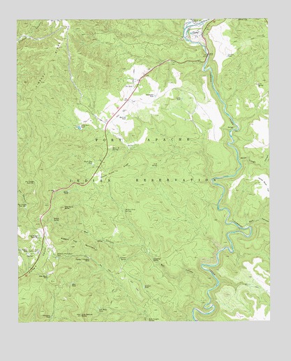
Carrizo, AZ USGS Topographic Map
Click on map above to begin viewing in our Map Viewer.

This topographic map contains these locations and features:
Feature Name Type Latitude Longitude GNIS ID View Map
A Ninetysix SpringSpringN33.9395°W110.3062°457View Map
Bat CanyonValleyN33.8887°W110.2809°1062View Map
Bear TankReservoirN33.8911°W110.3490°1150View Map
Butterball TankReservoirN33.9683°W110.3072°2308View Map
Calf Pasture TankReservoirN33.9035°W110.3712°2371View Map
Calf Pasture Tank Number OneReservoirN33.9106°W110.3649°2372View Map
CarrizoPopulated PlaceN33.9939°W110.2887°2481View Map
Carrizo Census Designated PlaceCensusN33.9866°W110.3314°2582748View Map
Carrizo TankReservoirN33.9848°W110.2710°2486View Map
Corduroy CreekStreamN33.9953°W110.2926°27945View Map
Cow Butte TankReservoirN33.8808°W110.3356°3439View Map
Cow Pasture ButteSummitN33.8778°W110.3443°3448View Map
Feed Box SpringSpringN33.9003°W110.3227°4559View Map
Felton TankReservoirN33.9506°W110.2840°39438View Map
Flying V Maintenance YardLocaleN33.9039°W110.3657°4705View Map
Flying V Pasture TankReservoirN33.9017°W110.3404°4706View Map
Fox Canyon Tank Number OneReservoirN33.9224°W110.3716°4808View Map
Fox Canyon Tank Number TwoReservoirN33.9329°W110.3670°4809View Map
Gully TankReservoirN33.9671°W110.2938°5421View Map
Highway Drift Fence TankReservoirN33.9017°W110.3563°5812View Map
Javelina TankReservoirN33.8895°W110.3133°6375View Map
John Moore TankReservoirN33.8945°W110.3607°6456View Map
Limestone SpringSpringN33.9013°W110.3090°7024View Map
Limestone TankReservoirN33.8775°W110.3588°7025View Map
Mud Cat TankReservoirN33.9600°W110.3218°8347View Map
Peach Tree TankReservoirN33.9403°W110.3386°9285View Map
Pit TankReservoirN33.9724°W110.3178°9545View Map
Ragged Top MountainSummitN33.9084°W110.3540°9904View Map
Red CanyonValleyN33.9145°W110.2623°10019View Map
Rock Canyon SpringSpringN33.8752°W110.3111°10387View Map
Rocky TankReservoirN33.9293°W110.3504°10466View Map
Spear-R SpringSpringN33.9459°W110.3284°11665View Map
Squaw Dress RidgeRidgeN33.9375°W110.3276°11736View Map
V Thirtyseven SpringSpringN33.9727°W110.2561°13140View Map
Water Trough CanyonValleyN33.9417°W110.2659°13384View Map
Wild Dove ButteSummitN33.9225°W110.3523°13761View Map
Wild Steer DamDamN33.9553°W110.3526°22384View Map
Wild Steer TankReservoirN33.9554°W110.3448°13777View Map
Willow SpringSpringN33.9170°W110.3579°13846View Map
Willow Trap SpringsSpringN33.9202°W110.3225°13878View Map

Note: Coordinates in the location and feature list above are referenced to NAD83 datum.


Copyright (C) 2008-2024 Ryan Niemi / Sunset Dynamics ... All Rights Reserved