TopoQuest Logo
Do you find TopoQuest useful?
Help keep TopoQuest running and adding new maps/features by donating!
Bitcoin:  19c7KJd3qBynnjoSw5npx9KScwjBe4ifkT
Litecoin:  LXs6TkuXGGXo1vDsWCkWVdjQX94eUKd6ui
Home View Maps Find Maps Find Places Resources & Links


Cedar Creek, Arizona Topographic Map

USGS Map Title: Cedar Creek, AZ
USGS Map MRC: 33110H2
DRG (GeoTIFF) Download: o33110h2.tif


Neighboring USGS Topographic Map Quads:


  Limestone Canyon South, AZ  
34110A3
 

  Long Tom Canyon, AZ  
34110A2
 

  Faught Ridge, AZ  
34110A1
 

  Carrizo, AZ  
33110H3
 

  Cedar Creek, AZ  
33110H2
 

  Round Top Mountain, AZ  
33110H1
 

  Carrizo SE, AZ  
33110G3
 

  Cone Butte, AZ  
33110G2
 

  Canyon Day, AZ  
33110G1


Map MRC Location:

N34°
W111°
N34°
W110°
H8 H7 H6 H5 H4 H3 H2 H1
G8 G7 G6 G5 G4 G3 G2 G1
F8 F7 F6 F5 F4 F3 F2 F1
E8 E7 E6 E5 E4 E3 E2 E1
D8 D7 D6 D5 D4 D3 D2 D1
C8 C7 C6 C5 C4 C3 C2 C1
B8 B7 B6 B5 B4 B3 B2 B1
A8 A7 A6 A5 A4 A3 A2 A1
N33°
W111°
N33°
W110°

Cedar Creek, AZ USGS 1:24K Topographic Map Preview:
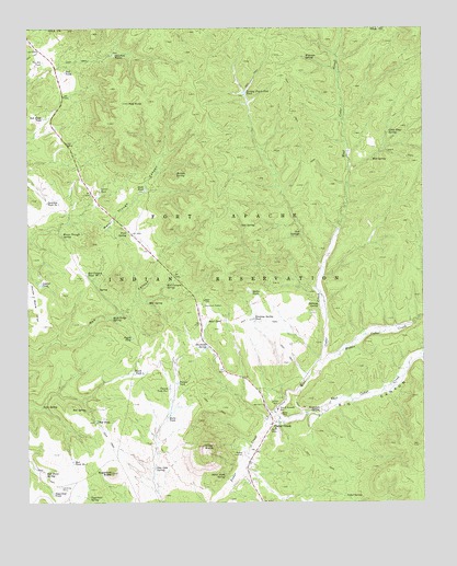
Cedar Creek, AZ USGS Topographic Map
Click on map above to begin viewing in our Map Viewer.

This topographic map contains these locations and features:
Feature Name Type Latitude Longitude GNIS ID View Map
Big CanyonValleyN33.8962°W110.1704°1295View Map
Bull SpringSpringN33.9658°W110.1414°2166View Map
Butte TankReservoirN33.8975°W110.2066°2304View Map
Cedar CreekPopulated PlaceN33.8956°W110.1737°2619View Map
Cedar Creek Census Designated PlaceCensusN33.9030°W110.1929°2582749View Map
Cedar Creek Rodeo GroundsLocaleN33.8878°W110.1826°22315View Map
Cedar SpringSpringN33.8766°W110.1504°2646View Map
Corner TankReservoirN33.9576°W110.2278°3275View Map
East Cedar CreekStreamN33.8978°W110.1720°28740View Map
Fork SpringSpringN33.9002°W110.2463°4730View Map
Fort Apache ReservationCivilN33.9284°W110.1328°4741View Map
Gopher TankReservoirN33.9322°W110.2467°5177View Map
Heifer TankReservoirN33.9305°W110.1800°5698View Map
Hidden SpringSpringN33.9615°W110.2036°5767View Map
Horse Bone FlatFlatN33.9295°W110.2496°5942View Map
John F Kennedy Day SchoolSchoolN33.8998°W110.1722°6446View Map
Junction Tank Number OneReservoirN33.9540°W110.2444°6539View Map
Junction TanksReservoirN33.9932°W110.2230°6540View Map
Little Trap SpringSpringN33.9725°W110.1364°7210View Map
Lower Junction Tank DamDamN33.9934°W110.2229°22349View Map
Middle Cedar CreekStreamN33.9128°W110.1557°7976View Map
Mud SpringSpringN33.9276°W110.2127°8363View Map
Owl SpringSpringN33.9481°W110.1831°9054View Map
Pasture TankReservoirN33.9065°W110.2034°9245View Map
Pasture Tank Number OneReservoirN33.9051°W110.2059°9247View Map
Peach TankReservoirN33.9092°W110.2143°9282View Map
Pete Cobb SpringSpringN33.8842°W110.2105°9341View Map
Piggie TankReservoirN33.9183°W110.2176°9421View Map
Red Canyon SpringSpringN33.9328°W110.2066°10021View Map
Red Canyon Tank Number TwoReservoirN33.9353°W110.2321°10025View Map
Red KnollSummitN33.9803°W110.2193°10071View Map
Red Knoll TankReservoirN33.9765°W110.2456°10073View Map
Red Point SpringSpringN33.8832°W110.2453°10112View Map
Red SpringSpringN33.8996°W110.2321°10148View Map
Red TankReservoirN33.8964°W110.2292°10155View Map
Red TankReservoirN33.9883°W110.2385°10156View Map
Red Tank Number OneReservoirN33.8857°W110.2365°10163View Map
Road TankReservoirN33.9227°W110.1938°10346View Map
Rock Ledge SpringSpringN33.9235°W110.2241°10409View Map
Salt SpringsSpringN33.9456°W110.1644°10771View Map
Silver ButteSummitN33.8898°W110.1954°11319View Map
Silver Butte SpringSpringN33.8822°W110.1884°11320View Map
South Goodwin TankReservoirN33.9584°W110.2318°22665View Map
Stake TankReservoirN33.9575°W110.2133°11764View Map
Stinking SpringSpringN33.9269°W110.1588°11841View Map
Stinking Spring TankReservoirN33.9236°W110.1791°11842View Map
Stockman SpringSpringN33.9160°W110.1938°11853View Map
Stockman StationLocaleN33.9264°W110.1954°11855View Map
Sugarloaf ButteSummitN33.8828°W110.2243°11914View Map
Sugarloaf TankReservoirN33.8773°W110.2429°11922View Map
Trail SpringSpringN33.9464°W110.2192°12674View Map
Turkey Track Flat TankReservoirN33.9830°W110.1819°12885View Map
Turkey Track Flat Tank DamDamN33.9823°W110.1818°22381View Map
Two Bit TankReservoirN33.9911°W110.2456°12979View Map
Water Trough SpringSpringN33.9453°W110.2396°13385View Map
Waterfall SpringSpringN33.8990°W110.1585°13390View Map
West Cedar CreekStreamN33.8978°W110.1720°13487View Map
Wigwam SpringSpringN33.9922°W110.1628°13744View Map

Note: Coordinates in the location and feature list above are referenced to NAD83 datum.


Copyright (C) 2008-2024 Ryan Niemi / Sunset Dynamics ... All Rights Reserved