TopoQuest Logo
Do you find TopoQuest useful?
Help keep TopoQuest running and adding new maps/features by donating!
Bitcoin:  19c7KJd3qBynnjoSw5npx9KScwjBe4ifkT
Litecoin:  LXs6TkuXGGXo1vDsWCkWVdjQX94eUKd6ui
Home View Maps Find Maps Find Places Resources & Links


Cartersville, Virginia Topographic Map

USGS Map Title: Cartersville, VA
USGS Map MRC: 37078F1
DRG (GeoTIFF) Download: o37078f1.tif


Neighboring USGS Topographic Map Quads:


  Columbia, VA  
37078G2
 

  Caledonia, VA  
37078G1
 

  South Anna, VA  
37077G8
 

  Lakeside Village, VA  
37078F2
 

  Cartersville, VA  
37078F1
 

  Goochland, VA  
37077F8
 

  Whiteville, VA  
37078E2
 

  Trenholm, VA  
37078E1
 

  Powhatan, VA  
37077E8


Map MRC Location:

N38°
W79°
N38°
W78°
H8 H7 H6 H5 H4 H3 H2 H1
G8 G7 G6 G5 G4 G3 G2 G1
F8 F7 F6 F5 F4 F3 F2 F1
E8 E7 E6 E5 E4 E3 E2 E1
D8 D7 D6 D5 D4 D3 D2 D1
C8 C7 C6 C5 C4 C3 C2 C1
B8 B7 B6 B5 B4 B3 B2 B1
A8 A7 A6 A5 A4 A3 A2 A1
N37°
W79°
N37°
W78°

Cartersville, VA USGS 1:24K Topographic Map Preview:
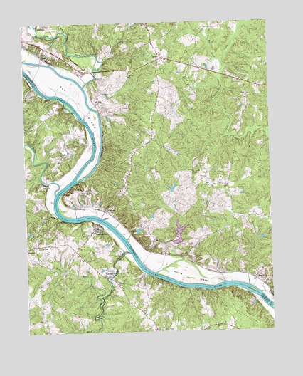
Cartersville, VA USGS Topographic Map
Click on map above to begin viewing in our Map Viewer.

This topographic map contains these locations and features:
Feature Name Type Latitude Longitude GNIS ID View Map
Antioch ChurchChurchN37.7204°W78.0114°1462513View Map
Bolling IslandIslandN37.6474°W78.0431°1463644View Map
Byrd CreekStreamN37.7246°W78.0944°1464208View Map
CartersvillePopulated PlaceN37.6674°W78.0883°1492721View Map
Cartersville CemeteryCemeteryN37.6604°W78.1133°1464494View Map
Cartersville Post OfficePost OfficeN37.6674°W78.0902°1494103View Map
Cartersville Volunteer Fire DepartmentBuildingN37.6630°W78.0934°2075462View Map
Corinth ChurchChurchN37.6888°W78.0375°1465258View Map
Davis CreekStreamN37.6268°W78.0878°1465652View Map
Deep RunStreamN37.6404°W78.0847°1465716View Map
Dogwood AcresPopulated PlaceN37.7099°W78.0608°1674261View Map
Ebenezer ChurchChurchN37.6899°W78.0383°1466149View Map
Elk HillPopulated PlaceN37.7176°W78.0875°1492910View Map
Elk Hill ChurchChurchN37.7282°W78.0711°1466218View Map
Elk IslandIslandN37.7165°W78.0956°1466220View Map
FifePopulated PlaceN37.7493°W78.0619°1492938View Map
Georges TavernPopulated PlaceN37.7357°W78.0539°1492994View Map
Goochland County Volunteer Fire and Rescue Company 4 FifeBuildingN37.7400°W78.0559°2086248View Map
HamiltonPopulated PlaceN37.6590°W78.1250°1495644View Map
Hunters TrailPopulated PlaceN37.7165°W78.0594°1674288View Map
IslandLocaleN37.7365°W78.1158°1468527View Map
James River LandingPopulated PlaceN37.6649°W78.0158°1674299View Map
Knorr DamDamN37.6601°W78.0831°1489568View Map
Little Byrd CreekStreamN37.7468°W78.1036°1469492View Map
Muddy CreekStreamN37.6568°W78.0722°1471225View Map
Muddy Creek MillsLocaleN37.6485°W78.0806°1494144View Map
New Hope ChurchChurchN37.6601°W78.1175°1471443View Map
New Hope School (historical)SchoolN37.6601°W78.1172°1494146View Map
PembertonPopulated PlaceN37.6746°W78.0847°1493410View Map
Picketts CreekStreamN37.6486°W78.0617°2786458View Map
Picketts Creek DamDamN37.6604°W78.0491°1489872View Map
Picketts Creek ReservoirReservoirN37.6648°W78.0472°1489873View Map
Pine TreeLocaleN37.6251°W78.0531°1472373View Map
Queensmeer DamDamN37.6818°W78.0514°1489891View Map
Queensmeer LakeReservoirN37.6829°W78.0500°1489892View Map
Saint James ChurchChurchN37.6638°W78.0933°1473738View Map
Stokes (historical)Populated PlaceN37.6549°W78.0447°1674331View Map
Stokes Airport (historical)AirportN37.6567°W78.0451°1498619View Map
TamworthPopulated PlaceN37.6482°W78.0808°1493683View Map
Tarred Rat CreekStreamN37.7329°W78.0236°1475483View Map
The Harambee School at Elk HillSchoolN37.7163°W78.0817°2464860View Map
Volchers DamDamN37.6718°W78.0614°1489901View Map
West ViewPopulated PlaceN37.6457°W78.0081°1477869View Map
Willis RiverStreamN37.6810°W78.1100°1476786View Map

Note: Coordinates in the location and feature list above are referenced to NAD83 datum.


Copyright (C) 2008-2024 Ryan Niemi / Sunset Dynamics ... All Rights Reserved