TopoQuest Logo
Do you find TopoQuest useful?
Help keep TopoQuest running and adding new maps/features by donating!
Bitcoin:  19c7KJd3qBynnjoSw5npx9KScwjBe4ifkT
Litecoin:  LXs6TkuXGGXo1vDsWCkWVdjQX94eUKd6ui
Home View Maps Find Maps Find Places Resources & Links


Trenholm, Virginia Topographic Map

USGS Map Title: Trenholm, VA
USGS Map MRC: 37078E1
DRG (GeoTIFF) Download: o37078e1.tif


Neighboring USGS Topographic Map Quads:


  Lakeside Village, VA  
37078F2
 

  Cartersville, VA  
37078F1
 

  Goochland, VA  
37077F8
 

  Whiteville, VA  
37078E2
 

  Trenholm, VA  
37078E1
 

  Powhatan, VA  
37077E8
 

  Cumberland, VA  
37078D2
 

  Ballsville, VA  
37078D1
 

  Chula, VA  
37077D8


Map MRC Location:

N38°
W79°
N38°
W78°
H8 H7 H6 H5 H4 H3 H2 H1
G8 G7 G6 G5 G4 G3 G2 G1
F8 F7 F6 F5 F4 F3 F2 F1
E8 E7 E6 E5 E4 E3 E2 E1
D8 D7 D6 D5 D4 D3 D2 D1
C8 C7 C6 C5 C4 C3 C2 C1
B8 B7 B6 B5 B4 B3 B2 B1
A8 A7 A6 A5 A4 A3 A2 A1
N37°
W79°
N37°
W78°

Trenholm, VA USGS 1:24K Topographic Map Preview:
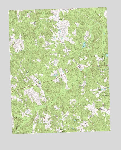
Trenholm, VA USGS Topographic Map
Click on map above to begin viewing in our Map Viewer.

This topographic map contains these locations and features:
Feature Name Type Latitude Longitude GNIS ID View Map
Bass PondReservoirN37.5424°W78.0093°1462825View Map
BelonaPopulated PlaceN37.5213°W78.0086°1463064View Map
Bevins PondReservoirN37.5515°W78.0882°1490651View Map
Bevins Pond DamDamN37.5501°W78.0881°1490650View Map
Bullhead PondReservoirN37.5420°W78.0054°1464082View Map
District 5CivilN37.5854°W78.0106°1927272View Map
HatchersPopulated PlaceN37.5804°W78.0514°1499535View Map
Hatchers Dairy FarmLocaleN37.6181°W78.0636°2676015View Map
Hideaway LakeReservoirN37.5119°W78.0446°1467999View Map
Hideaway LakePopulated PlaceN37.5085°W78.0447°1674217View Map
Horsepen BranchStreamN37.5976°W78.0206°1468281View Map
Little Zion ChurchChurchN37.6249°W78.0492°1469697View Map
Lower Powhatan DamDamN37.5768°W78.0031°1490611View Map
Maple Swamp CreekStreamN37.5826°W78.0967°1470081View Map
Maxey Mill CreekStreamN37.5135°W78.1086°1470204View Map
Moore CreekStreamN37.5532°W78.0403°1470709View Map
Mount Moriah ChurchChurchN37.5004°W78.0617°1470944View Map
Mount Pero ChurchChurchN37.5032°W78.0564°1471017View Map
Mount Zion Baptist ChurchChurchN37.5626°W78.0114°1471135View Map
Muddy Creek ChurchChurchN37.6126°W78.0606°1471229View Map
Nixons DamDamN37.5585°W78.0664°1490652View Map
Noname Number 14529 DamDamN37.5435°W78.0014°1490653View Map
Powhatan County Fire Department Company 5 - Deep Creek Volunteer FireBuildingN37.5622°W78.0454°2086091View Map
Powhatan LakesReservoirN37.5766°W78.0012°1472755View Map
Providence ChurchChurchN37.5246°W78.0086°1472827View Map
Redford DamDamN37.5907°W78.0286°1490613View Map
Redford PondReservoirN37.5877°W78.0303°1473076View Map
Sallee CreekStreamN37.6024°W78.0050°1477932View Map
Smiths CrossroadsPopulated PlaceN37.5663°W78.0119°1477765View Map
Stegers CreekStreamN37.5788°W78.0053°1475112View Map
TrenholmPopulated PlaceN37.5949°W78.0619°1477821View Map
Williss DamDamN37.5951°W78.0581°1490654View Map

Note: Coordinates in the location and feature list above are referenced to NAD83 datum.


Copyright (C) 2008-2025 Ryan Niemi / Sunset Dynamics ... All Rights Reserved