TopoQuest Logo
Do you find TopoQuest useful?
Help keep TopoQuest running and adding new maps/features by donating!
Bitcoin:  19c7KJd3qBynnjoSw5npx9KScwjBe4ifkT
Litecoin:  LXs6TkuXGGXo1vDsWCkWVdjQX94eUKd6ui
Home View Maps Find Maps Find Places Resources & Links


Cascade, Michigan Topographic Map

USGS Map Title: Cascade, MI
USGS Map MRC: 42085H4
DRG (GeoTIFF) Download: o42085h4.tif


Neighboring USGS Topographic Map Quads:


  Rockford, MI  
43085A5
 

  Cannonsburg, MI  
43085A4
 

  Smyrna, MI  
43085A3
 

  Grand Rapids East, MI  
42085H5
 

  Cascade, MI  
42085H4
 

  Lowell, MI  
42085H3
 

  Caledonia, MI  
42085G5
 

  Alto, MI  
42085G4
 

  Freeport, MI  
42085G3


Map MRC Location:

N43°
W86°
N43°
W85°
H8 H7 H6 H5 H4 H3 H2 H1
G8 G7 G6 G5 G4 G3 G2 G1
F8 F7 F6 F5 F4 F3 F2 F1
E8 E7 E6 E5 E4 E3 E2 E1
D8 D7 D6 D5 D4 D3 D2 D1
C8 C7 C6 C5 C4 C3 C2 C1
B8 B7 B6 B5 B4 B3 B2 B1
A8 A7 A6 A5 A4 A3 A2 A1
N42°
W86°
N42°
W85°

Cascade, MI USGS 1:24K Topographic Map Preview:
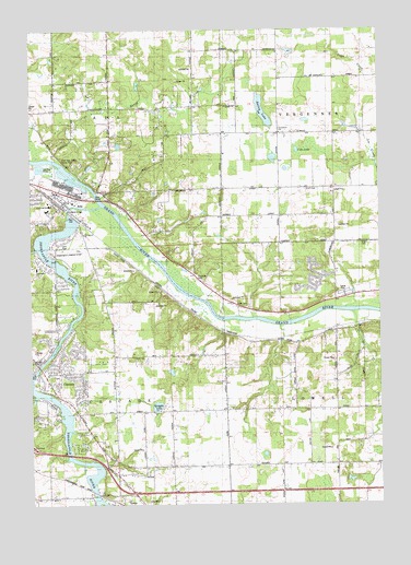
Cascade, MI USGS Topographic Map
Click on map above to begin viewing in our Map Viewer.

This topographic map contains these locations and features:
Feature Name Type Latitude Longitude GNIS ID View Map
AdaPopulated PlaceN42.9542°W85.4889°619810View Map
Ada Bible ChurchChurchN42.8850°W85.4472°2567081View Map
Ada Christian Reformed ChurchChurchN42.9547°W85.4936°2567078View Map
Ada Community Reformed ChurchChurchN42.9542°W85.4881°2567079View Map
Ada Covered Bridge Historical MarkerParkN42.9525°W85.4867°2566770View Map
Ada Elementary SchoolSchoolN42.9528°W85.4942°2567086View Map
Ada Post OfficePost OfficeN42.9572°W85.4906°2567063View Map
Ada StationLocaleN42.9556°W85.4922°2567059View Map
Ada Township Fire / Rescue Department Station 1BuildingN42.9586°W85.4958°2567076View Map
Ada Township ParkParkN42.9439°W85.4792°2567088View Map
Ada Vista Elementary SchoolSchoolN42.9539°W85.4934°623256View Map
Bailey LakeLakeN42.9786°W85.4166°620453View Map
CascadePopulated PlaceN42.9123°W85.4981°622825View Map
Cascade CemeteryCemeteryN42.9090°W85.4911°2567108View Map
Cascade Charter Township Fire Department Station 2BuildingN42.9108°W85.4694°2636158View Map
Cascade Christian ChurchChurchN42.9131°W85.4978°2570388View Map
Cascade Christian Church Historical MarkerParkN42.9131°W85.4983°2566779View Map
Cascade Post Office (historical)Post OfficeN42.9122°W85.4978°2570747View Map
Cascade Township Hall Historical MarkerParkN42.9125°W85.4975°2566780View Map
Charter Township of CascadeCivilN42.8980°W85.4906°1626037View Map
Chief Hazy Cloud County ParkParkN42.9661°W85.4889°623187View Map
Cole LakeLakeN42.9684°W85.4045°623590View Map
Cupp/SJVS Landing Strip (historical)AirportN42.9948°W85.4542°1624325View Map
Evergreen Missionary ChurchChurchN42.9311°W85.4097°2565314View Map
Forest HillsPopulated PlaceN42.9595°W85.4897°1867318View Map
Forest Hills Census Designated PlaceCensusN42.9576°W85.4895°2392999View Map
Forest Hills Presbyterian ChurchChurchN42.8992°W85.4839°2570385View Map
Honey CreekStreamN42.9609°W85.4825°628525View Map
Interchange 46CrossingN42.8883°W85.4919°2566411View Map
Key Heights Village Mobile Home ParkPopulated PlaceN42.9308°W85.3867°2565329View Map
Krum Blanding CemeteryCemeteryN42.9581°W85.4011°629880View Map
Lion ParkParkN42.9436°W85.4872°630529View Map
Little Cook Cemetery (historical)CemeteryN42.9100°W85.4806°2567107View Map
McCords CreekStreamN42.8759°W85.4756°631844View Map
McPherson SchoolSchoolN42.9942°W85.4111°632021View Map
Orlando J Odell House/Vegennes Post Office Historical MarkerParkN42.9728°W85.4053°2567134View Map
Quail Ridge Golf ClubLocaleN42.9033°W85.4661°2567087View Map
Quiggle LakeLakeN42.9009°W85.4552°635565View Map
Rolfe CemeteryCemeteryN42.9272°W85.4264°636132View Map
Saint Michael's Episcopal ChurchChurchN42.9106°W85.4953°2570387View Map
Shaggy Pines Dog ParkParkN42.8931°W85.4606°2567080View Map
Snow CemeteryCemeteryN42.9078°W85.4309°2567106View Map
Snow ChurchChurchN42.9073°W85.4309°638199View Map
Somerville AirportAirportN42.9418°W85.4858°1623767View Map
Thornapple RiverStreamN42.9536°W85.4750°1614795View Map
Thornapple SchoolSchoolN42.9373°W85.4978°1614796View Map
Thornwood ChurchChurchN42.9464°W85.4806°1614803View Map
Township of AdaCivilN42.9841°W85.4897°1625798View Map
Van Strien Company AirportAirportN42.9238°W85.3750°1624015View Map
Vergennes CemeteryCemeteryN42.9739°W85.4105°2570142View Map
Vergennes ChurchChurchN42.9728°W85.4106°1615541View Map
Vergennes District Number Eleven School House Historical MarkerParkN42.9894°W85.4108°2567132View Map
Vergennes United Methodist Church Historical MarkerParkN42.9731°W85.4119°2566847View Map
WKWM-AM (Kentwood)TowerN42.9370°W85.4556°1625254View Map
Wright CemeteryCemeteryN42.9436°W85.3817°1616834View Map

Note: Coordinates in the location and feature list above are referenced to NAD83 datum.


Copyright (C) 2008-2024 Ryan Niemi / Sunset Dynamics ... All Rights Reserved