TopoQuest Logo
Do you find TopoQuest useful?
Help keep TopoQuest running and adding new maps/features by donating!
Bitcoin:  19c7KJd3qBynnjoSw5npx9KScwjBe4ifkT
Litecoin:  LXs6TkuXGGXo1vDsWCkWVdjQX94eUKd6ui
Home View Maps Find Maps Find Places Resources & Links


Castor Gulch, Colorado Topographic Map

USGS Map Title: Castor Gulch, CO
USGS Map MRC: 40107D5
DRG (GeoTIFF) Download: o40107d5.tif


Neighboring USGS Topographic Map Quads:


  Pine Ridge, CO  
40107E6
 

  Craig, CO  
40107E5
 

  Ralph White Lake, CO  
40107E4
 

  Round Bottom, CO  
40107D6
 

  Castor Gulch, CO  
40107D5
 

  Breeze Mountain, CO  
40107D4
 

  Monument Butte, CO  
40107C6
 

  Hamilton, CO  
40107C5
 

  Pagoda, CO  
40107C4


Map MRC Location:

N41°
W108°
N41°
W107°
H8 H7 H6 H5 H4 H3 H2 H1
G8 G7 G6 G5 G4 G3 G2 G1
F8 F7 F6 F5 F4 F3 F2 F1
E8 E7 E6 E5 E4 E3 E2 E1
D8 D7 D6 D5 D4 D3 D2 D1
C8 C7 C6 C5 C4 C3 C2 C1
B8 B7 B6 B5 B4 B3 B2 B1
A8 A7 A6 A5 A4 A3 A2 A1
N40°
W108°
N40°
W107°

Castor Gulch, CO USGS 1:24K Topographic Map Preview:
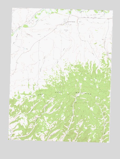
Castor Gulch, CO USGS Topographic Map
Click on map above to begin viewing in our Map Viewer.

This topographic map contains these locations and features:
Feature Name Type Latitude Longitude GNIS ID View Map
Blair Coal MineMineN40.4930°W107.5862°1683203View Map
Bogenschutz CreekStreamN40.4752°W107.6234°171242View Map
Brant MineMineN40.4147°W107.5709°1683204View Map
Castor GulchValleyN40.3753°W107.6198°171387View Map
Craig Holding and Evaporation DamDamN40.4633°W107.5956°200554View Map
Craig Holding and Evaporation ReservoirReservoirN40.4627°W107.5952°200555View Map
Craig Raw Water DamDamN40.4866°W107.5973°200576View Map
Craig Raw Water ReservoirReservoirN40.4866°W107.5973°200577View Map
Craig South HighlandsPopulated PlaceN40.4850°W107.5631°171386View Map
Craig-Moffat AirportAirportN40.4954°W107.5208°204327View Map
Deacon GulchValleyN40.4868°W107.5072°171312View Map
Deep Cut DitchCanalN40.4872°W107.5159°201988View Map
Eberle MineMineN40.4916°W107.6126°1683205View Map
Flume GulchValleyN40.4928°W107.5435°171389View Map
Fortification CreekStreamN40.4989°W107.5401°171183View Map
Hamilton MineMineN40.3780°W107.5637°1763886View Map
Hamilton SchoolSchoolN40.3758°W107.6215°171382View Map
Johnson GulchValleyN40.4797°W107.6141°171391View Map
Mack PitMineN40.4889°W107.5409°1683206View Map
Mine Number FiveMineN40.4877°W107.6109°1683207View Map
Mount Evans MineMineN40.4858°W107.6065°1683208View Map
Phillips MineMineN40.4889°W107.6051°1683209View Map
Pyeatt GulchValleyN40.4733°W107.5832°171390View Map
Thompson HillSummitN40.4791°W107.5576°171384View Map
Trapper Strip MineMineN40.4033°W107.5542°1683210View Map
Walker MineMineN40.4722°W107.5103°171383View Map
Whitlock MineMineN40.3841°W107.6217°1735765View Map

Note: Coordinates in the location and feature list above are referenced to NAD83 datum.


Copyright (C) 2008-2024 Ryan Niemi / Sunset Dynamics ... All Rights Reserved