TopoQuest Logo
Do you find TopoQuest useful?
Help keep TopoQuest running and adding new maps/features by donating!
Bitcoin:  19c7KJd3qBynnjoSw5npx9KScwjBe4ifkT
Litecoin:  LXs6TkuXGGXo1vDsWCkWVdjQX94eUKd6ui
Home View Maps Find Maps Find Places Resources & Links


Catawissa, Pennsylvania Topographic Map

USGS Map Title: Catawissa, PA
USGS Map MRC: 40076H4
DRG (GeoTIFF) Download: o40076h4.tif


Neighboring USGS Topographic Map Quads:


  Millville, PA  
41076A5
 

  Bloomsburg, PA  
41076A4
 

  Mifflinville, PA  
41076A3
 

  Danville, PA  
40076H5
 

  Catawissa, PA  
40076H4
 

  Shumans, PA  
40076H3
 

  Shamokin, PA  
40076G5
 

  Mount Carmel, PA  
40076G4
 

  Ashland, PA  
40076G3


Map MRC Location:

N41°
W77°
N41°
W76°
H8 H7 H6 H5 H4 H3 H2 H1
G8 G7 G6 G5 G4 G3 G2 G1
F8 F7 F6 F5 F4 F3 F2 F1
E8 E7 E6 E5 E4 E3 E2 E1
D8 D7 D6 D5 D4 D3 D2 D1
C8 C7 C6 C5 C4 C3 C2 C1
B8 B7 B6 B5 B4 B3 B2 B1
A8 A7 A6 A5 A4 A3 A2 A1
N40°
W77°
N40°
W76°

Catawissa, PA USGS 1:24K Topographic Map Preview:
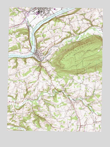
Catawissa, PA USGS Topographic Map
Click on map above to begin viewing in our Map Viewer.

This topographic map contains these locations and features:
Feature Name Type Latitude Longitude GNIS ID View Map
Bethel ChurchChurchN40.8940°W76.4927°1169396View Map
Bethel Church CemeteryCemeteryN40.8941°W76.4934°2777544View Map
Bloomsburg Area High SchoolSchoolN40.9901°W76.4547°1207418View Map
Bloomsburg Area Middle SchoolSchoolN40.9906°W76.4552°1207416View Map
Bloomsburg Fire Department Station 10BuildingN40.9957°W76.4519°2652642View Map
Bloomsburg Municipal AirportAirportN40.9955°W76.4393°1194153View Map
Borough of CatawissaCivilN40.9530°W76.4603°1215125View Map
Breezy AcresPopulated PlaceN40.9798°W76.4280°1212532View Map
Broadt Personal Use AirportAirportN40.9982°W76.3837°1194154View Map
CatawissaPopulated PlaceN40.9520°W76.4597°1171329View Map
Catawissa Borough Police DepartmentBuildingN40.9529°W76.4613°2777030View Map
Catawissa CreekStreamN40.9526°W76.4672°1171330View Map
Catawissa Hose Company 1BuildingN40.9504°W76.4603°2653456View Map
Catawissa Post OfficePost OfficeN40.9531°W76.4617°2772627View Map
Clayton SchoolSchoolN40.9334°W76.4880°1171953View Map
Corn RunStreamN40.9581°W76.4644°1172461View Map
East BloomsburgPopulated PlaceN40.9906°W76.4349°1203470View Map
Emanuel ChurchChurchN40.9918°W76.3766°1174205View Map
Esther ChurchChurchN40.9073°W76.4633°1174329View Map
Fisher CemeteryCemeteryN40.9919°W76.3758°1174814View Map
Fishing CreekStreamN40.9773°W76.4672°1192467View Map
Freewill ChurchChurchN40.9226°W76.3969°1175218View Map
Greater Columbia Medical Transport ServiceBuildingN40.9935°W76.4583°2722240View Map
Greenwood CemeteryCemeteryN40.9503°W76.4623°2777541View Map
Hemlock CreekStreamN40.9951°W76.4736°1176800View Map
Hillside Lutheran Church CemeteryCemeteryN40.9510°W76.4541°2777540View Map
Kinney RunStreamN40.9898°W76.4486°1182196View Map
Lake GloryReservoirN40.9053°W76.4586°1212533View Map
Lick RunStreamN40.8973°W76.3880°1179307View Map
McIntyre CemeteryCemeteryN40.9220°W76.4404°2777543View Map
McIntyre SchoolSchoolN40.9212°W76.4411°1180732View Map
Memorial Elementary SchoolSchoolN40.9987°W76.4552°1207414View Map
Montour RunStreamN40.9854°W76.4744°1181478View Map
Montour Township Fire Company Station 240BuildingN40.9816°W76.4758°2652725View Map
Mount Zion CemeteryCemeteryN40.9319°W76.4680°1181904View Map
Mount Zion ChurchChurchN40.9304°W76.5000°1181929View Map
NewlinPopulated PlaceN40.8851°W76.3841°1182397View Map
NumidiaPopulated PlaceN40.8806°W76.4022°1182715View Map
Numidia Census Designated PlaceCensusN40.8783°W76.4034°2389597View Map
Numidia Post OfficePost OfficeN40.8820°W76.4026°2773227View Map
Old Quaker ChurchChurchN40.8981°W76.3986°1182931View Map
Our Lady of Mercy CemeteryCemeteryN40.9043°W76.4153°1183117View Map
Parrs MillPopulated PlaceN40.9070°W76.4722°1183344View Map
Pensyls MillPopulated PlaceN40.9031°W76.4891°1204380View Map
Quaker CemeteryCemeteryN40.9508°W76.4617°2777538View Map
Queen CityPopulated PlaceN40.9151°W76.4358°1184539View Map
Roaring Creek CemeteryCemeteryN40.9037°W76.4153°1185167View Map
RupertPopulated PlaceN40.9793°W76.4741°1204556View Map
Rupert Census Designated PlaceCensusN40.9760°W76.4797°2389788View Map
SlabtownPopulated PlaceN40.9051°W76.4088°1187777View Map
Slabtown Census Designated PlaceCensusN40.9051°W76.4059°2390305View Map
Southside Ambulance CompanyBuildingN40.9504°W76.4604°2722245View Map
Tank SchoolSchoolN40.9470°W76.4488°1189261View Map
Township of CatawissaCivilN40.9527°W76.4375°1216276View Map
Township of FranklinCivilN40.9191°W76.4952°1216280View Map
Township of LocustCivilN40.8797°W76.3861°1216283View Map
Township of MainCivilN40.9783°W76.3811°1216285View Map
Union CemeteryCemeteryN40.9508°W76.4579°2777539View Map
Valley SchoolSchoolN40.9818°W76.4916°1190313View Map
W W Evans Memorial Elementary SchoolSchoolN40.9918°W76.4791°1207417View Map
WHLM-AM (Bloomsburg)TowerN40.9940°W76.4894°1200475View Map
WHLM-FM (Bloomsburg)TowerN40.9951°W76.4972°1210240View Map

Note: Coordinates in the location and feature list above are referenced to NAD83 datum.


Copyright (C) 2008-2025 Ryan Niemi / Sunset Dynamics ... All Rights Reserved