TopoQuest Logo
Do you find TopoQuest useful?
Help keep TopoQuest running and adding new maps/features by donating!
Bitcoin:  19c7KJd3qBynnjoSw5npx9KScwjBe4ifkT
Litecoin:  LXs6TkuXGGXo1vDsWCkWVdjQX94eUKd6ui
Home View Maps Find Maps Find Places Resources & Links


Danville, Pennsylvania Topographic Map

USGS Map Title: Danville, PA
USGS Map MRC: 40076H5
DRG (GeoTIFF) Download: o40076h5.tif


Neighboring USGS Topographic Map Quads:


  Washingtonville, PA  
41076A6
 

  Millville, PA  
41076A5
 

  Bloomsburg, PA  
41076A4
 

  Riverside, PA  
40076H6
 

  Danville, PA  
40076H5
 

  Catawissa, PA  
40076H4
 

  Trevorton, PA  
40076G6
 

  Shamokin, PA  
40076G5
 

  Mount Carmel, PA  
40076G4


Map MRC Location:

N41°
W77°
N41°
W76°
H8 H7 H6 H5 H4 H3 H2 H1
G8 G7 G6 G5 G4 G3 G2 G1
F8 F7 F6 F5 F4 F3 F2 F1
E8 E7 E6 E5 E4 E3 E2 E1
D8 D7 D6 D5 D4 D3 D2 D1
C8 C7 C6 C5 C4 C3 C2 C1
B8 B7 B6 B5 B4 B3 B2 B1
A8 A7 A6 A5 A4 A3 A2 A1
N40°
W77°
N40°
W76°

Danville, PA USGS 1:24K Topographic Map Preview:
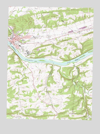
Danville, PA USGS Topographic Map
Click on map above to begin viewing in our Map Viewer.

This topographic map contains these locations and features:
Feature Name Type Latitude Longitude GNIS ID View Map
Blizzards RunStreamN40.9609°W76.6122°1214652View Map
Blue HillSummitN40.9362°W76.6163°1169878View Map
Borough of DanvilleCivilN40.9615°W76.6121°1215487View Map
BoydPopulated PlaceN40.9356°W76.5980°1203134View Map
BroppsLocaleN40.9868°W76.5691°1206800View Map
Cherokee Golf CourseLocaleN40.9331°W76.5897°1205634View Map
Clarks IslandIslandN40.9509°W76.5030°1171930View Map
Continental Fire Company 3BuildingN40.9706°W76.6171°2653426View Map
DanvillePopulated PlaceN40.9634°W76.6127°1213617View Map
Danville Alliance ChurchChurchN40.9662°W76.5980°1214645View Map
Danville Ambulance ServiceBuildingN40.9629°W76.6098°2722206View Map
Danville Area Senior High SchoolSchoolN40.9587°W76.5997°1207194View Map
Danville Elementary SchoolSchoolN40.9576°W76.6141°1207193View Map
Danville Mennonite ChurchChurchN40.9084°W76.5833°1214651View Map
Danville Middle SchoolSchoolN40.9643°W76.6202°1207574View Map
Danville Police DepartmentBuildingN40.9620°W76.6180°2776931View Map
Danville Post OfficePost OfficeN40.9613°W76.6179°2779838View Map
Danville State HospitalHospitalN40.9489°W76.5955°1212994View Map
Deal High SchoolSchoolN40.9587°W76.5980°1214649View Map
East End Fire Company Station 60BuildingN40.9651°W76.5927°2652805View Map
Friendship Fire Company 1BuildingN40.9592°W76.6183°2653425View Map
Frosty Valley Country ClubLocaleN40.9720°W76.5741°1213207View Map
Geisinger HealthSouth Rehabilitation HospitalBuildingN40.9691°W76.6034°2718133View Map
Geisinger Medical CenterHospitalN40.9677°W76.6058°1175508View Map
Goodwill Hose Company 4BuildingN40.9669°W76.6098°2653424View Map
GrovaniaPopulated PlaceN40.9740°W76.5250°1203725View Map
Holy Family ConventBuildingN40.9679°W76.6211°1177266View Map
Hopewell ParkParkN40.9595°W76.5727°1214644View Map
Kase RunStreamN40.9945°W76.6083°1178242View Map
KasevillePopulated PlaceN40.9981°W76.5941°1203911View Map
Knoebels GrovePopulated PlaceN40.8784°W76.5058°1178616View Map
Lawrence L Knoebel Covered BridgeBridgeN40.8784°W76.5038°1214653View Map
Little Roaring CreekStreamN40.9373°W76.5563°1179659View Map
Logan RunStreamN40.9393°W76.5933°1179816View Map
Mahoning Cooper Elementary SchoolSchoolN40.9676°W76.5869°1207192View Map
Mahoning Township Police DepartmentBuildingN40.9658°W76.5981°2777167View Map
MechanicsvillePopulated PlaceN40.9665°W76.5866°1180849View Map
Mechanicsville Census Designated PlaceCensusN40.9676°W76.5860°2389466View Map
Menches IslandIslandN40.9465°W76.5141°1180923View Map
Montour County Sheriff's OfficeBuildingN40.9599°W76.6193°2776967View Map
Mugser RunStreamN40.8781°W76.5036°1217364View Map
Old Saint Josephs CemeteryCemeteryN40.9726°W76.6136°1214647View Map
QuitmanPopulated PlaceN40.9065°W76.5647°1204458View Map
Reeder Covered Bridge (historical)BridgeN40.8859°W76.5069°1209327View Map
Reeds IslandIslandN40.9406°W76.5747°1209253View Map
RidgevillePopulated PlaceN40.9687°W76.5650°1185051View Map
Riegel Covered BridgeBridgeN40.9123°W76.5133°1185055View Map
Roaring CreekStreamN40.9393°W76.5283°1185166View Map
Roaring CreekPopulated PlaceN40.9323°W76.5233°1204521View Map
Rohrbach Covered Bridge (historical)BridgeN40.9004°W76.5116°1209331View Map
Rush ChurchChurchN40.8848°W76.6058°1185639View Map
Saint Cyrils AcademySchoolN40.9634°W76.6019°1185898View Map
Saint Johns ChurchChurchN40.9045°W76.5483°1186148View Map
Saint Josephs SchoolSchoolN40.9645°W76.6155°1214648View Map
Saint Peters ChurchChurchN40.9668°W76.5213°1186675View Map
Sechler RunStreamN40.9626°W76.6186°1213099View Map
Shamokin HillSummitN40.8798°W76.5750°1193325View Map
Sharp RidgeRidgeN40.9209°W76.5283°1187373View Map
Sharp Ridge CemeteryCemeteryN40.9167°W76.5477°1187374View Map
Sharp Ridge Church (historical)ChurchN40.9159°W76.5483°1197872View Map
South Branch Roaring CreekStreamN40.9079°W76.5105°1188037View Map
South Danville StationLocaleN40.9559°W76.6238°1212995View Map
Stone Castle Motel AirportAirportN40.9730°W76.5195°1194146View Map
Straub ChurchChurchN40.9981°W76.5838°1188861View Map
The PinnaclePillarN40.9156°W76.5227°1189445View Map
Toby RunStreamN40.9437°W76.5991°1189614View Map
Township of CooperCivilN40.9614°W76.5443°1216888View Map
Township of MahoningCivilN40.9647°W76.6005°1216892View Map
Township of MayberryCivilN40.9115°W76.5435°1216893View Map
Township of MontourCivilN40.9738°W76.5000°1216287View Map
Union CornerPopulated PlaceN40.9001°W76.5775°1204850View Map
Vastines IslandIslandN40.9398°W76.5827°1190369View Map
Washies PlaygroundParkN40.9526°W76.6091°1209306View Map
Washington Fire and Hose Company 2BuildingN40.9601°W76.6089°2653315View Map
Welsh Congregational ChurchChurchN40.9684°W76.6152°1214646View Map
Wilson CemeteryCemeteryN40.9965°W76.5913°1214643View Map
WPGM-FM (Danville)TowerN40.9879°W76.5472°1200272View Map

Note: Coordinates in the location and feature list above are referenced to NAD83 datum.


Copyright (C) 2008-2024 Ryan Niemi / Sunset Dynamics ... All Rights Reserved