TopoQuest Logo
Do you find TopoQuest useful?
Help keep TopoQuest running and adding new maps/features by donating!
Bitcoin:  19c7KJd3qBynnjoSw5npx9KScwjBe4ifkT
Litecoin:  LXs6TkuXGGXo1vDsWCkWVdjQX94eUKd6ui
Home View Maps Find Maps Find Places Resources & Links


Parkers Prairie, Minnesota Topographic Map

USGS Map Title: Parkers Prairie, MN
USGS Map MRC: 46095B3
DRG (GeoTIFF) Download: o46095b3.tif


Neighboring USGS Topographic Map Quads:


  Henning, MN  
46095C4
 

  Henning SE, MN  
46095C3
 

  Wrightstown, MN  
46095C2
 

  Parkers Prairie NW, MN  
46095B4
 

  Parkers Prairie, MN  
46095B3
 

  Eagle Bend NW, MN  
46095B2
 

  Lake Miltona West, MN  
46095A4
 

  Lake Miltona East, MN  
46095A3
 

  Rose City, MN  
46095A2


Map MRC Location:

N47°
W96°
N47°
W95°
H8 H7 H6 H5 H4 H3 H2 H1
G8 G7 G6 G5 G4 G3 G2 G1
F8 F7 F6 F5 F4 F3 F2 F1
E8 E7 E6 E5 E4 E3 E2 E1
D8 D7 D6 D5 D4 D3 D2 D1
C8 C7 C6 C5 C4 C3 C2 C1
B8 B7 B6 B5 B4 B3 B2 B1
A8 A7 A6 A5 A4 A3 A2 A1
N46°
W96°
N46°
W95°

Parkers Prairie, MN USGS 1:24K Topographic Map Preview:
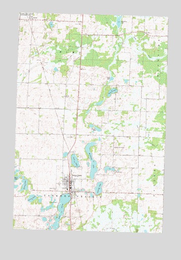
Parkers Prairie, MN USGS Topographic Map
Click on map above to begin viewing in our Map Viewer.

This topographic map contains these locations and features:
Feature Name Type Latitude Longitude GNIS ID View Map
AlmoraLocaleN46.2461°W95.3678°2073064View Map
AlmoraPopulated PlaceN46.2464°W95.3656°639301View Map
Almora LakeLakeN46.2058°W95.2959°639302View Map
Almora Post Office (historical)Post OfficeN46.2464°W95.3653°2073065View Map
Augusta LakeLakeN46.1501°W95.3045°639515View Map
Church of the ConfessionChurchN46.1736°W95.2931°641211View Map
City of Parkers PrairieCivilN46.1527°W95.3296°2396151View Map
Clarno LakeLakeN46.1431°W95.3601°641256View Map
Cora LakeLakeN46.1651°W95.3249°641491View Map
County Ditch Number FourCanalN46.2230°W95.3378°642057View Map
County Ditch Number NineteenCanalN46.1830°W95.2650°641769View Map
Curtis LakeLakeN46.2135°W95.2963°642564View Map
Elmo ChurchChurchN46.2022°W95.3342°643310View Map
Elmo Post Office (historical)Post OfficeN46.2167°W95.3333°2073015View Map
First Baptist ChurchChurchN46.1531°W95.3286°2072790View Map
First Evangelical Lutheran ChurchChurchN46.1508°W95.3281°2072789View Map
Gausdale Lutheran Church CemeteryCemeteryN46.2019°W95.3336°2072696View Map
Graven LakeLakeN46.1840°W95.3068°644394View Map
Horsehead LakeLakeN46.1669°W95.3109°645198View Map
Immanuel Lutheran ChurchChurchN46.1472°W95.3264°2072788View Map
Lake AdleyLakeN46.1376°W95.3351°639215View Map
Miller LakeLakeN46.1547°W95.3749°647878View Map
Parkers PrairieLocaleN46.1528°W95.3253°2072781View Map
Parkers PrairiePopulated PlaceN46.1530°W95.3289°649161View Map
Parkers Prairie CemeteryCemeteryN46.1491°W95.3395°649162View Map
Parkers Prairie City PoliceBuildingN46.1534°W95.3289°2072786View Map
Parkers Prairie Community AmbulanceBuildingN46.1536°W95.3294°2721350View Map
Parkers Prairie Fire DepartmentBuildingN46.1536°W95.3296°2072785View Map
Parkers Prairie Medical ClinicHospitalN46.1531°W95.3275°2072784View Map
Parkers Prairie ParkPopulated PlaceN46.1517°W95.3350°2072782View Map
Parkers Prairie Post Office (historical)Post OfficeN46.1531°W95.3297°2072783View Map
Reese LakeLakeN46.1487°W95.3674°649914View Map
Saint Paul's Lutheran Church Cemetery (historical)CemeteryN46.2389°W95.3097°2072695View Map
Saint Williams Catholic ChurchChurchN46.1531°W95.3311°2072787View Map
Saint Williams CemeteryCemeteryN46.1508°W95.3372°651084View Map
Swedish CemeteryCemeteryN46.1597°W95.2911°652928View Map
Township of ElmoCivilN46.2388°W95.3342°664085View Map
Township of Parkers PrairieCivilN46.1514°W95.3659°665258View Map
Wing River LakeLakeN46.2485°W95.2929°654257View Map

Note: Coordinates in the location and feature list above are referenced to NAD83 datum.


Copyright (C) 2008-2025 Ryan Niemi / Sunset Dynamics ... All Rights Reserved