TopoQuest Logo
Do you find TopoQuest useful?
Help keep TopoQuest running and adding new maps/features by donating!
Bitcoin:  19c7KJd3qBynnjoSw5npx9KScwjBe4ifkT
Litecoin:  LXs6TkuXGGXo1vDsWCkWVdjQX94eUKd6ui
Home View Maps Find Maps Find Places Resources & Links


Cavendish, Vermont Topographic Map

USGS Map Title: Cavendish, VT
USGS Map MRC: 43072D5
DRG (GeoTIFF) Download: o43072d5.tif


Neighboring USGS Topographic Map Quads:


  Plymouth, VT  
43072E6
 

  Woodstock South, VT  
43072E5
 

  Hartland, VT  
43072E4
 

  Ludlow, VT  
43072D6
 

  Cavendish, VT  
43072D5
 

  Windsor, VT  
43072D4
 

  Andover, VT  
43072C6
 

  Chester, VT  
43072C5
 

  Springfield, VT  
43072C4


Map MRC Location:

N44°
W73°
N44°
W72°
H8 H7 H6 H5 H4 H3 H2 H1
G8 G7 G6 G5 G4 G3 G2 G1
F8 F7 F6 F5 F4 F3 F2 F1
E8 E7 E6 E5 E4 E3 E2 E1
D8 D7 D6 D5 D4 D3 D2 D1
C8 C7 C6 C5 C4 C3 C2 C1
B8 B7 B6 B5 B4 B3 B2 B1
A8 A7 A6 A5 A4 A3 A2 A1
N43°
W73°
N43°
W72°

Cavendish, VT USGS 1:24K Topographic Map Preview:
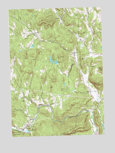
Cavendish, VT USGS Topographic Map
Click on map above to begin viewing in our Map Viewer.

This topographic map contains these locations and features:
Feature Name Type Latitude Longitude GNIS ID View Map
Albert C Lord State ForestForestN43.4203°W72.5523°1456119View Map
Alder Meadow BrookStreamN43.4745°W72.5890°1456131View Map
AmsdenPopulated PlaceN43.4059°W72.5059°1456159View Map
Amsden CemeteryCemeteryN43.4711°W72.5309°1456160View Map
Bests Covered BridgeBridgeN43.4551°W72.5162°1922254View Map
Bowen HillSummitN43.4520°W72.5568°1456530View Map
Caton Place CampgroundLocaleN43.4145°W72.5520°1922293View Map
CavendishPopulated PlaceN43.3820°W72.6081°1456794View Map
Cavendish Baptist ChurchChurchN43.3842°W72.6056°1922294View Map
Cavendish Census Designated PlaceCensusN43.3863°W72.6064°2586623View Map
Cavendish CenterPopulated PlaceN43.4101°W72.6056°1456795View Map
Cavendish Center School (historical)SchoolN43.4109°W72.6062°1922295View Map
Cavendish DamDamN43.3817°W72.5979°1766364View Map
Cavendish Fire DepartmentBuildingN43.3824°W72.6070°2121311View Map
Cavendish GorgeValleyN43.3848°W72.5981°1456796View Map
Cavendish Post OfficePost OfficeN43.3823°W72.6096°1922296View Map
Cavendish Universalist ChurchChurchN43.3834°W72.6056°1922297View Map
Cavendish Village CemeteryCemeteryN43.3853°W72.6070°1922298View Map
Coffeen CemeteryCemeteryN43.4396°W72.6231°1922312View Map
Crown Point Camping AreaLocaleN43.3851°W72.5015°1922319View Map
Darby BrookStreamN43.4748°W72.5901°1457108View Map
DownersPopulated PlaceN43.4004°W72.5143°1457190View Map
EaglesheadSummitN43.4045°W72.5445°1457242View Map
Eddy CemeteryCemeteryN43.4280°W72.5211°1922341View Map
Elm BrookStreamN43.4029°W72.5881°1457357View Map
FelchvillePopulated PlaceN43.4565°W72.5379°1457418View Map
Felchville CemeteryCemeteryN43.4561°W72.5416°1922349View Map
GreenbushPopulated PlaceN43.4170°W72.5179°1457640View Map
Greenbush CemeteryCemeteryN43.4214°W72.5210°1922380View Map
HammondsvillePopulated PlaceN43.4903°W72.5531°1457708View Map
Hardy HillSummitN43.4306°W72.5676°1457735View Map
Hawks Mountain Wildlife Management AreaParkN43.3829°W72.5579°1922398View Map
Hurricane HillSummitN43.4753°W72.5251°1457943View Map
Keyes MountainSummitN43.4865°W72.5734°1458080View Map
Knapp BrookStreamN43.4465°W72.5334°1458115View Map
Knapp Brook Pond Number 1ReservoirN43.4471°W72.5627°1766432View Map
Knapp Brook Pond Number 2ReservoirN43.4491°W72.5692°1766434View Map
Knapp Brook PondsLakeN43.4495°W72.5690°1458116View Map
Knapp Brook Site Number 1 DamDamN43.4451°W72.5612°1766431View Map
Knapp Brook Site Number 2 DamDamN43.4473°W72.5658°1766433View Map
Knapp Brook Wildlife Management AreaParkN43.4495°W72.5656°1922433View Map
Little Ascutney MountainSummitN43.4251°W72.5037°1458231View Map
Mount Union CemeteryCemeteryN43.4128°W72.6059°1458575View Map
Old Revolutionary War CemeteryCemeteryN43.4123°W72.6012°1458834View Map
Perkinsville Post OfficePost OfficeN43.4002°W72.5140°1922525View Map
Pest CemeteryCemeteryN43.4218°W72.6185°1922719View Map
Pierson PeakSummitN43.4386°W72.5005°1458962View Map
Reading Elementary SchoolSchoolN43.4532°W72.5364°1922555View Map
Reading Fire and RescueBuildingN43.4679°W72.5322°2121296View Map
Reading Hill BrookStreamN43.4842°W72.5512°1459150View Map
Reading Municipal ForestForestN43.4470°W72.5531°1922556View Map
Reading Post OfficePost OfficeN43.4557°W72.5375°2759997View Map
Robinson HillSummitN43.4498°W72.5279°1459220View Map
Rowe HillSummitN43.4742°W72.5073°1459270View Map
Rush Meadow School (historical)SchoolN43.4587°W72.5181°1922574View Map
Sawyer - Stand CemeteryCemeteryN43.4834°W72.6192°1459391View Map
Sawyer Stand SchoolSchoolN43.4792°W72.6190°1922587View Map
Sheddsville HillSummitN43.4826°W72.5059°1459473View Map
South ReadingPopulated PlaceN43.4742°W72.5893°1459610View Map
South Reading CemeteryCemeteryN43.4745°W72.5868°1922631View Map
South Reading Schoolhouse (historical)SchoolN43.4745°W72.5893°1922633View Map
Star HillSummitN43.4312°W72.5784°1459676View Map
Stockin School (historical)SchoolN43.4334°W72.5284°1922628View Map
Tarbell Hill SchoolSchoolN43.4067°W72.5668°1922647View Map
Town of CavendishCivilN43.4052°W72.6038°1462066View Map
Town of ReadingCivilN43.4983°W72.5944°1462183View Map
Tracer BrookStreamN43.4104°W72.5970°1459944View Map
Twentymile StreamStreamN43.3934°W72.5918°1459974View Map
Upper Falls Covered BridgeBridgeN43.3984°W72.5220°1922675View Map
Wardner HillSummitN43.4917°W72.5331°1460062View Map
Weathersfield Municipal ForestForestN43.3973°W72.5115°1922699View Map
West Weathersfield Volunteer Fire DepartmentBuildingN43.4009°W72.5135°2121297View Map
WhitesvillePopulated PlaceN43.3917°W72.5943°1460230View Map
Widow HillSummitN43.4228°W72.5712°1460243View Map
Willow BrookStreamN43.4548°W72.5143°1460285View Map

Note: Coordinates in the location and feature list above are referenced to NAD83 datum.


Copyright (C) 2008-2024 Ryan Niemi / Sunset Dynamics ... All Rights Reserved