TopoQuest Logo
Do you find TopoQuest useful?
Help keep TopoQuest running and adding new maps/features by donating!
Bitcoin:  19c7KJd3qBynnjoSw5npx9KScwjBe4ifkT
Litecoin:  LXs6TkuXGGXo1vDsWCkWVdjQX94eUKd6ui
Home View Maps Find Maps Find Places Resources & Links


Plymouth, Vermont Topographic Map

USGS Map Title: Plymouth, VT
USGS Map MRC: 43072E6
DRG (GeoTIFF) Download: o43072e6.tif


Neighboring USGS Topographic Map Quads:


  Pico Peak, VT  
43072F7
 

  Delectable Mountain, VT  
43072F6
 

  Woodstock North, VT  
43072F5
 

  Killington Peak, VT  
43072E7
 

  Plymouth, VT  
43072E6
 

  Woodstock South, VT  
43072E5
 

  Mount Holly, VT  
43072D7
 

  Ludlow, VT  
43072D6
 

  Cavendish, VT  
43072D5


Map MRC Location:

N44°
W73°
N44°
W72°
H8 H7 H6 H5 H4 H3 H2 H1
G8 G7 G6 G5 G4 G3 G2 G1
F8 F7 F6 F5 F4 F3 F2 F1
E8 E7 E6 E5 E4 E3 E2 E1
D8 D7 D6 D5 D4 D3 D2 D1
C8 C7 C6 C5 C4 C3 C2 C1
B8 B7 B6 B5 B4 B3 B2 B1
A8 A7 A6 A5 A4 A3 A2 A1
N43°
W73°
N43°
W72°

Plymouth, VT USGS 1:24K Topographic Map Preview:
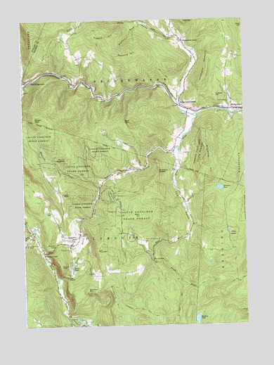
Plymouth, VT USGS Topographic Map
Click on map above to begin viewing in our Map Viewer.

This topographic map contains these locations and features:
Feature Name Type Latitude Longitude GNIS ID View Map
Bald MountainSummitN43.5837°W72.6882°1456227View Map
Blueberry HillSummitN43.5037°W72.6982°1456494View Map
Blueberry LedgesCliffN43.5631°W72.6729°1456497View Map
BridgewaterPopulated PlaceN43.5881°W72.6251°1456564View Map
Bridgewater CenterPopulated PlaceN43.6165°W72.6593°1456565View Map
Bridgewater Center CemeteryCemeteryN43.6184°W72.6664°1922273View Map
Bridgewater Center Oak ChapelChurchN43.6170°W72.6587°1922274View Map
Bridgewater Congregational ChurchChurchN43.5881°W72.6268°1922275View Map
Bridgewater CornersPopulated PlaceN43.5884°W72.6559°1456566View Map
Bridgewater Corners Post OfficePost OfficeN43.5877°W72.6560°1922276View Map
Bridgewater Hill CemeteryCemeteryN43.6142°W72.7227°1922277View Map
Broad BrookStreamN43.5865°W72.6509°1456574View Map
Calvin Coolidge BirthplaceLocaleN43.5348°W72.7212°1456720View Map
Calvin Coolidge Homestead DistrictParkN43.5356°W72.7220°1922289View Map
Calvin Coolidge State ParkParkN43.5473°W72.6857°1922290View Map
Cold BrookStreamN43.6234°W72.6793°1456967View Map
Coolidge State ParkParkN43.5531°W72.7004°2027187View Map
Dailey HollowValleyN43.6187°W72.6618°1457089View Map
East MountainSummitN43.5323°W72.7084°1457301View Map
Five CornersLocaleN43.5267°W72.6770°1457443View Map
Grass PondLakeN43.5469°W72.7372°1457611View Map
Great Roaring BrookStreamN43.5387°W72.7443°1457626View Map
Hale HollowValleyN43.5698°W72.6632°1457683View Map
Hudson HillSummitN43.5940°W72.6409°1457931View Map
Mecawee PondReservoirN43.5558°W72.6390°1458411View Map
Mecawee Pond DamDamN43.5559°W72.6390°1766601View Map
Moore Pond Upper DamDamN43.5234°W72.7229°1766673View Map
Moores PondsReservoirN43.5220°W72.7219°1458527View Map
Morgan PeakSummitN43.5859°W72.7429°1458538View Map
Mount PleasantSummitN43.5681°W72.7259°1459011View Map
Mount Pleasant CemeteryCemeteryN43.5913°W72.6323°1458572View Map
Mount TomSummitN43.5237°W72.7290°1459923View Map
Mount TomSummitN43.5045°W72.6254°1459925View Map
North Branch Ottauquechee RiverStreamN43.5909°W72.6615°1458702View Map
Ohio HillSummitN43.6231°W72.6254°1458816View Map
Old NotchSummitN43.5206°W72.7243°1458831View Map
Pinney HollowValleyN43.5706°W72.6645°1458986View Map
Pinney Hollow BrookStreamN43.5701°W72.6620°1458987View Map
PlymouthPopulated PlaceN43.5359°W72.7215°1459015View Map
Plymouth - Five Corners CemeteryCemeteryN43.5341°W72.6812°1459021View Map
Plymouth Elementary SchoolSchoolN43.5355°W72.7439°1459019View Map
Plymouth Fire DepartmentBuildingN43.5342°W72.7429°2121501View Map
Plymouth NotchGapN43.5340°W72.7301°1459017View Map
Plymouth Notch CemeteryCemeteryN43.5312°W72.7234°1459018View Map
Plymouth Notch Historic DistrictParkN43.5359°W72.7187°1922533View Map
Plymouth Notch Ski AreaLocaleN43.5340°W72.7487°1459265View Map
Plymouth Post OfficePost OfficeN43.5355°W72.7220°1922534View Map
Plymouth UnionPopulated PlaceN43.5301°W72.7387°1459020View Map
Plymouth Village CampgroundLocaleN43.5340°W72.7407°1922536View Map
Ragged HillSummitN43.6156°W72.7023°1459133View Map
Raymond HillSummitN43.6103°W72.6959°1459148View Map
Reading PondLakeN43.5019°W72.6530°1459151View Map
Reservoir BrookStreamN43.5995°W72.7476°1459164View Map
Richmond HillSummitN43.5676°W72.6465°1459181View Map
Slack HillSummitN43.5453°W72.6843°1459530View Map
Soltudus MountainSummitN43.5142°W72.7145°1459561View Map
Southgate MountainSummitN43.5984°W72.6487°1459629View Map
Toplift CemeteryCemeteryN43.5722°W72.6644°1922655View Map
Town of PlymouthCivilN43.5226°W72.7174°1462176View Map
Union Christian ChurchChurchN43.5359°W72.7223°1922669View Map
Upper Moore PondReservoirN43.5247°W72.7225°1766674View Map
Washburn BrookStreamN43.6237°W72.6815°1460070View Map
West BridgewaterPopulated PlaceN43.6001°W72.7487°1460121View Map
Whetstone BrookStreamN43.5567°W72.7068°1460204View Map
Wood PeakSummitN43.5540°W72.7240°1460308View Map

Note: Coordinates in the location and feature list above are referenced to NAD83 datum.


Copyright (C) 2008-2024 Ryan Niemi / Sunset Dynamics ... All Rights Reserved