TopoQuest Logo
Do you find TopoQuest useful?
Help keep TopoQuest running and adding new maps/features by donating!
Bitcoin:  19c7KJd3qBynnjoSw5npx9KScwjBe4ifkT
Litecoin:  LXs6TkuXGGXo1vDsWCkWVdjQX94eUKd6ui
Home View Maps Find Maps Find Places Resources & Links


Centertown, Tennessee Topographic Map

USGS Map Title: Centertown, TN
USGS Map MRC: 35085F8
DRG (GeoTIFF) Download: o35085f8.tif


Neighboring USGS Topographic Map Quads:


  Woodbury, TN  
35086G1
 

  Short Mountain, TN  
35085G8
 

  Dibrell, TN  
35085G7
 

  Hollow Springs, TN  
35086F1
 

  Centertown, TN  
35085F8
 

  McMinnville, TN  
35085F7
 

  Fredonia, TN  
35086E1
 

  Morrison, TN  
35085E8
 

  Viola, TN  
35085E7


Map MRC Location:

N36°
W86°
N36°
W85°
H8 H7 H6 H5 H4 H3 H2 H1
G8 G7 G6 G5 G4 G3 G2 G1
F8 F7 F6 F5 F4 F3 F2 F1
E8 E7 E6 E5 E4 E3 E2 E1
D8 D7 D6 D5 D4 D3 D2 D1
C8 C7 C6 C5 C4 C3 C2 C1
B8 B7 B6 B5 B4 B3 B2 B1
A8 A7 A6 A5 A4 A3 A2 A1
N35°
W86°
N35°
W85°

Centertown, TN USGS 1:24K Topographic Map Preview:
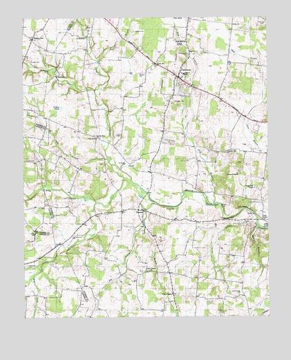
Centertown, TN USGS Topographic Map
Click on map above to begin viewing in our Map Viewer.

This topographic map contains these locations and features:
Feature Name Type Latitude Longitude GNIS ID View Map
A 1 Tree FarmLocaleN35.6697°W85.8792°2662628View Map
Barren Fork ChurchChurchN35.7003°W85.9625°1304970View Map
Bates HillPopulated PlaceN35.7306°W85.9314°1314634View Map
Bates Hill Cumberland Presbyterian ChurchChurchN35.7306°W85.9319°1320514View Map
Bethel Hill Baptist ChurchChurchN35.7401°W85.9167°1305157View Map
Big Spring CemeteryCemeteryN35.6892°W85.9483°1277410View Map
Brown CemeteryCemeteryN35.6470°W85.9978°1278534View Map
Bullpen CreekStreamN35.7190°W85.9633°1305521View Map
Campbell CemeteryCemeteryN35.7320°W85.9958°1279430View Map
Caney BranchStreamN35.6715°W85.9300°1279559View Map
Caney Branch ChurchChurchN35.6440°W85.9358°1279561View Map
Cates BranchStreamN35.6898°W85.9564°1269427View Map
CentertownPopulated PlaceN35.7251°W85.9205°1305810View Map
Centertown Church of ChristChurchN35.7253°W85.9217°1646734View Map
Centertown Community Volunteer Fire Department Station 1BuildingN35.7266°W85.9186°2654616View Map
Centertown Division (historical)CensusN35.7273°W85.9250°1648996View Map
Centertown Elementary SchoolSchoolN35.7095°W85.9169°1320520View Map
Centertown High School (historical)SchoolN35.7267°W85.9178°1320521View Map
Centertown United Methodist ChurchChurchN35.7248°W85.9192°1646735View Map
ClearmontPopulated PlaceN35.7253°W85.9828°1314855View Map
Commissioner District 10CivilN35.7229°W85.9173°2464329View Map
Crisp (historical)Populated PlaceN35.6612°W85.9944°1643527View Map
Crisp SchoolSchoolN35.6598°W85.9947°1281626View Map
Crisp SpringPopulated PlaceN35.6653°W85.8780°1314909View Map
Crisp SpringSpringN35.6621°W85.8772°1281627View Map
Cross Roads School (historical)SchoolN35.6859°W85.9375°1320527View Map
Cummings Chapel School (historical)SchoolN35.6851°W85.8905°1320529View Map
Cummins ChapelChurchN35.6848°W85.8905°1306237View Map
De Berry SwampSwampN35.7123°W85.9802°1282229View Map
Dog BranchStreamN35.6720°W85.9025°1282586View Map
Dry BranchStreamN35.6628°W85.9392°1282883View Map
Fountain Spring CemeteryCemeteryN35.6581°W85.9753°1284715View Map
French CemeteryCemeteryN35.6701°W85.9269°1284906View Map
Fuston CemeteryCemeteryN35.7009°W85.9522°1285053View Map
Garner BranchStreamN35.6656°W85.8805°1285170View Map
Grange Hall CemeteryCemeteryN35.6798°W85.8819°1646739View Map
Grange Hall ChapelChurchN35.6787°W85.8819°1306504View Map
Grange Hall School (historical)SchoolN35.6790°W85.8822°1320541View Map
Green Hill School (historical)SchoolN35.6334°W85.8878°1320542View Map
Gregory SpringSpringN35.7388°W85.9183°1286247View Map
Gum SpringSpringN35.7499°W85.9223°1286418View Map
Harrington CemeteryCemeteryN35.7151°W85.9228°1286939View Map
Henegar BranchStreamN35.6620°W85.8803°1287412View Map
Hulett CemeteryCemeteryN35.6517°W85.9755°1288685View Map
Ivy BluffCliffN35.7462°W85.9675°1289117View Map
Ivy Bluff ChurchChurchN35.7417°W85.9678°1306610View Map
Ivy Bluff School (historical)SchoolN35.7415°W85.9672°1320551View Map
Kelsy BranchStreamN35.6412°W85.9961°1290052View Map
Liberty CreekStreamN35.6459°W85.9911°1291148View Map
McAfee BranchStreamN35.6287°W85.9944°1293067View Map
Miller BranchStreamN35.7317°W85.9614°1293911View Map
Mud CreekStreamN35.6459°W85.9911°1295001View Map
New (historical)Populated PlaceN35.6831°W85.9230°1311887View Map
Nicholson Springs (historical)Populated PlaceN35.6617°W85.8842°1311888View Map
North Prong Barren ForkStreamN35.6806°W85.9425°1295933View Map
Oak GrovePopulated PlaceN35.6998°W85.9625°1315618View Map
Oakgrove School (historical)SchoolN35.7009°W85.9630°1320565View Map
Old Fellowship CemeteryCemeteryN35.6351°W85.8894°1296303View Map
Pine BluffCliffN35.6703°W85.8883°1297506View Map
Pleasant Hill ChurchChurchN35.6940°W85.8958°1297868View Map
Pleasant ViewPopulated PlaceN35.7415°W85.9950°1315744View Map
Pleasant View Baptist ChurchChurchN35.7423°W85.9961°1643612View Map
Pleasant View School (historical)SchoolN35.7415°W85.9955°1643613View Map
Poor House CemeteryCemeteryN35.7470°W85.8766°1298139View Map
Rains CemeteryCemeteryN35.6687°W85.9558°1298846View Map
Smoot BluffCliffN35.6659°W85.8947°1270730View Map
South Prong Barren ForkStreamN35.6728°W85.9630°1311903View Map
Starkey RockPillarN35.6706°W85.9028°1271266View Map
Tolbert CemeteryCemeteryN35.6906°W85.9986°1272725View Map
Town of CentertownCivilN35.7253°W85.9199°2406243View Map
TrousdalePopulated PlaceN35.6695°W85.9389°1314424View Map
Trousdale Church of ChristChurchN35.6698°W85.9492°1646746View Map
Unity ChurchChurchN35.7467°W85.8925°1273271View Map
Whitlock CemeteryCemeteryN35.7267°W85.9400°1274482View Map
Wilson ChapelChurchN35.6345°W85.9247°1274825View Map
Witty CreekStreamN35.6728°W85.9628°1274922View Map
Youngblood CreekStreamN35.7190°W85.9633°1275339View Map
Younghood CemeteryCemeteryN35.7442°W85.9433°1275341View Map

Note: Coordinates in the location and feature list above are referenced to NAD83 datum.


Copyright (C) 2008-2024 Ryan Niemi / Sunset Dynamics ... All Rights Reserved