TopoQuest Logo
Do you find TopoQuest useful?
Help keep TopoQuest running and adding new maps/features by donating!
Bitcoin:  19c7KJd3qBynnjoSw5npx9KScwjBe4ifkT
Litecoin:  LXs6TkuXGGXo1vDsWCkWVdjQX94eUKd6ui
Home View Maps Find Maps Find Places Resources & Links


Viola, Tennessee Topographic Map

USGS Map Title: Viola, TN
USGS Map MRC: 35085E7
DRG (GeoTIFF) Download: o35085e7.tif


Neighboring USGS Topographic Map Quads:


  Centertown, TN  
35085F8
 

  McMinnville, TN  
35085F7
 

  Cardwell Mountain, TN  
35085F6
 

  Morrison, TN  
35085E8
 

  Viola, TN  
35085E7
 

  Irving College, TN  
35085E6
 

  Hillsboro, TN  
35085D8
 

  Cane Hollow, TN  
35085D7
 

  Altamont, TN  
35085D6


Map MRC Location:

N36°
W86°
N36°
W85°
H8 H7 H6 H5 H4 H3 H2 H1
G8 G7 G6 G5 G4 G3 G2 G1
F8 F7 F6 F5 F4 F3 F2 F1
E8 E7 E6 E5 E4 E3 E2 E1
D8 D7 D6 D5 D4 D3 D2 D1
C8 C7 C6 C5 C4 C3 C2 C1
B8 B7 B6 B5 B4 B3 B2 B1
A8 A7 A6 A5 A4 A3 A2 A1
N35°
W86°
N35°
W85°

Viola, TN USGS 1:24K Topographic Map Preview:
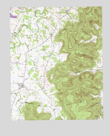
Viola, TN USGS Topographic Map
Click on map above to begin viewing in our Map Viewer.

This topographic map contains these locations and features:
Feature Name Type Latitude Longitude GNIS ID View Map
Bascom CemeteryCemeteryN35.5959°W85.8689°1646729View Map
Bascom ChurchChurchN35.5959°W85.8694°1304983View Map
Beech HollowValleyN35.5910°W85.7570°1276847View Map
Big SpringSpringN35.5120°W85.7514°1310841View Map
Brookside SchoolSchoolN35.6209°W85.7966°1278493View Map
Butterson KnobSummitN35.5659°W85.7900°1311859View Map
Chestnut GrovePopulated PlaceN35.5112°W85.8172°1647182View Map
Chestnut Grove CemeteryCemeteryN35.5112°W85.8166°1317703View Map
Chestnut Grove ChurchChurchN35.5115°W85.8169°1305887View Map
Corinth School (historical)SchoolN35.5234°W85.8516°1320526View Map
Fultz CemeteryCemeteryN35.5040°W85.8122°1285028View Map
Fultz CoveValleyN35.5096°W85.8123°1285030View Map
Fultz CreekStreamN35.5481°W85.8483°1285031View Map
Gwynn CemeteryCemeteryN35.5490°W85.8616°1286472View Map
Hanner Highland School and Female Academy (historical)SchoolN35.5951°W85.8708°1646737View Map
Harvest Farms LakeReservoirN35.6155°W85.8717°1301964View Map
Harvest Farms Lake DamDamN35.6144°W85.8659°1301965View Map
Hubbard CoveValleyN35.5006°W85.8731°1288577View Map
Keel BranchStreamN35.5823°W85.8661°1269699View Map
Little Hickory CreekStreamN35.5309°W85.8628°1291526View Map
Macedonia CemeteryCemeteryN35.5151°W85.8153°1292400View Map
Morrison Division (historical)CensusN35.6051°W85.8614°1649000View Map
Mount Olive BridgeBridgeN35.5004°W85.8339°1269820View Map
Mount ZionPopulated PlaceN35.5712°W85.8205°1315564View Map
Mount Zion CemeteryCemeteryN35.5712°W85.8214°1646743View Map
Mount Zion School (historical)SchoolN35.5704°W85.8211°1320561View Map
Mount Zion United Methodist ChurchChurchN35.5706°W85.8203°1320560View Map
Northcutts CovePopulated PlaceN35.5045°W85.7533°1647187View Map
Northcutts CoveValleyN35.5046°W85.7540°1303512View Map
Northcutts Cove CemeteryCemeteryN35.5181°W85.7539°1317709View Map
Northcutts Cove ChurchChurchN35.5176°W85.7536°1295956View Map
Northcutts Cove SchoolSchoolN35.5023°W85.7569°1295957View Map
Rockcliff ChurchChurchN35.5940°W85.8189°1299806View Map
Rodgers HollowValleyN35.5559°W85.7553°1299963View Map
Smith HollowStreamN35.5595°W85.7578°1270674View Map
Solomon HollowValleyN35.5983°W85.7543°1270811View Map
The NarrowsGapN35.5917°W85.7564°1311886View Map
Town of ViolaCivilN35.5387°W85.8606°2406805View Map
VervillaPopulated PlaceN35.5956°W85.8714°1314457View Map
ViolaPopulated PlaceN35.5384°W85.8591°1304310View Map
Viola Church of ChristChurchN35.5379°W85.8594°1646747View Map
Viola Elementary SchoolSchoolN35.5484°W85.8575°1648193View Map
Viola Fire DepartmentBuildingN35.5382°W85.8576°2654858View Map
Viola Post OfficePost OfficeN35.5382°W85.8591°1651524View Map
Viola United Methodist ChurchChurchN35.5409°W85.8611°1646748View Map
West Fork Hickory CreekStreamN35.5870°W85.8614°1274175View Map
White Hall ChurchChurchN35.5765°W85.8291°1274368View Map

Note: Coordinates in the location and feature list above are referenced to NAD83 datum.


Copyright (C) 2008-2024 Ryan Niemi / Sunset Dynamics ... All Rights Reserved