TopoQuest Logo
Do you find TopoQuest useful?
Help keep TopoQuest running and adding new maps/features by donating!
Bitcoin:  19c7KJd3qBynnjoSw5npx9KScwjBe4ifkT
Litecoin:  LXs6TkuXGGXo1vDsWCkWVdjQX94eUKd6ui
Home View Maps Find Maps Find Places Resources & Links


Central City West, Nebraska Topographic Map

USGS Map Title: Central City West, NE
USGS Map MRC: 41098A1
DRG (GeoTIFF) Download: o41098a1.tif


Neighboring USGS Topographic Map Quads:


  Archer, NE  
41098B2
 

  Hord, NE  
41098B1
 

  Polk NW, NE  
41097B8
 

  Chapman, NE  
41098A2
 

  Central City West, NE  
41098A1
 

  Central City East, NE  
41097A8
 

  Phillips, NE  
40098H2
 

  Murphy, NE  
40098H1
 

  Hampton, NE  
40097H8


Map MRC Location:

N42°
W99°
N42°
W98°
H8 H7 H6 H5 H4 H3 H2 H1
G8 G7 G6 G5 G4 G3 G2 G1
F8 F7 F6 F5 F4 F3 F2 F1
E8 E7 E6 E5 E4 E3 E2 E1
D8 D7 D6 D5 D4 D3 D2 D1
C8 C7 C6 C5 C4 C3 C2 C1
B8 B7 B6 B5 B4 B3 B2 B1
A8 A7 A6 A5 A4 A3 A2 A1
N41°
W99°
N41°
W98°

Central City West, NE USGS 1:24K Topographic Map Preview:
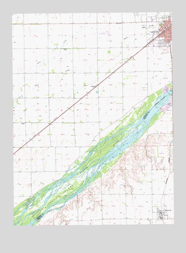
Central City West, NE USGS Topographic Map
Click on map above to begin viewing in our Map Viewer.

This topographic map contains these locations and features:
Feature Name Type Latitude Longitude GNIS ID View Map
Aurora Cooperative Elevator Company - Marquette ElevatorLocaleN41.0031°W98.0095°1881617View Map
Bushes IslandIslandN41.0172°W98.0892°827813View Map
Cancer ClinicHospitalN41.1070°W98.0026°1881284View Map
Cargill Incorporated ElevatorLocaleN41.1161°W98.0042°1881273View Map
Central CityPopulated PlaceN41.1158°W98.0017°828051View Map
Central CityLocaleN41.1139°W98.0067°1881278View Map
Central City Ambulance ServiceBuildingN41.1159°W98.0007°2553776View Map
Central City Dental ClinicHospitalN41.1153°W98.0014°1881287View Map
Central City Family Dental CenterHospitalN41.1061°W98.0034°1881289View Map
Central City MallLocaleN41.1158°W98.0017°1881272View Map
Central City Middle SchoolSchoolN41.1042°W98.0014°1881307View Map
Central City Municipal Airport - Larry Reineke FieldAirportN41.1138°W98.0506°837519View Map
Central City Police DepartmentBuildingN41.1159°W98.0007°1881274View Map
Central City Volunteer Fire DepartmentBuildingN41.1141°W98.0027°2553275View Map
Central Vision ClinicHospitalN41.1156°W98.0026°1881290View Map
Christian ChurchChurchN41.1186°W98.0031°1881292View Map
City of Central CityCivilN41.1133°W98.0002°837913View Map
Community Bible ChurchChurchN41.1156°W98.0078°1881295View Map
Community Care of AmericaHospitalN41.1053°W98.0026°1881286View Map
Evangelical Free ChurchChurchN41.1131°W98.0014°1881303View Map
Faith Baptist ChurchChurchN41.0078°W98.0128°1881620View Map
Friends Meeting HouseChurchN41.1181°W98.0045°1881293View Map
Grace Lutheran ChurchChurchN41.1122°W98.0006°1881298View Map
Kernel FieldParkN41.1231°W98.0087°1881281View Map
Larsen DamDamN41.0217°W98.0337°1767081View Map
Larsen ReservoirReservoirN41.0226°W98.0343°1767082View Map
Litzenberg Memorial County HospitalHospitalN41.1073°W98.0026°1881283View Map
Lone Tree Historical MarkerParkN41.1158°W98.0017°1881270View Map
Lone Tree Medical AssociationHospitalN41.1070°W98.0028°1881288View Map
Lone Tree ParkParkN41.1058°W98.0009°1881279View Map
MarquettePopulated PlaceN41.0031°W98.0095°831058View Map
MarquetteLocaleN41.0061°W98.0092°1881618View Map
Marquette Post OfficePost OfficeN41.0068°W98.0111°1881615View Map
Marquette Public SchoolSchoolN41.0036°W98.0106°1881619View Map
Marquette Volunteer Fire and RescueBuildingN41.0067°W98.0108°2553353View Map
Merrick County FairgroundsLocaleN41.1167°W98.0226°1881306View Map
Mid Nebraska Foot ClinicHospitalN41.1070°W98.0026°1881285View Map
Nebraska Christian SchoolsSchoolN41.1195°W98.0364°1881282View Map
North ParkParkN41.1178°W98.0087°1881280View Map
PaddockPopulated PlaceN41.0817°W98.0606°835404View Map
Platte Valley Trailer CourtPopulated PlaceN41.1158°W98.0017°1881271View Map
Presbyterian ChurchChurchN41.1139°W98.0012°1881299View Map
Saint Michaels Catholic ChurchChurchN41.1081°W98.0064°1881301View Map
Saint Pauls Lutheran ChurchChurchN41.1114°W98.0062°1881296View Map
School Number 12SchoolN41.1039°W98.0851°836190View Map
School Number 3SchoolN41.0320°W98.1123°836533View Map
School Number 38SchoolN41.0606°W98.0770°836656View Map
School Number 39SchoolN41.0603°W98.1156°836668View Map
School Number 48SchoolN41.0900°W98.0395°836778View Map
School Number 8SchoolN41.1183°W98.0398°837099View Map
Sherman ReservoirReservoirN41.0228°W98.0389°1766978View Map
Tom Sherman DamDamN41.0229°W98.0385°1766977View Map
Township of Lone TreeCivilN41.1184°W98.0277°838111View Map
United Co-op Incorporated ElevatorLocaleN41.0031°W98.0095°1881616View Map
United Methodist ChurchChurchN41.1070°W98.0045°1881300View Map
Valley View Golf CourseLocaleN41.0417°W98.0087°1881759View Map
Village of MarquetteCivilN41.0063°W98.0098°2399261View Map
Vollers Chiropractic ClinicHospitalN41.1156°W98.0026°1881291View Map
Wood RiverStreamN41.0083°W98.1237°834859View Map

Note: Coordinates in the location and feature list above are referenced to NAD83 datum.


Copyright (C) 2008-2025 Ryan Niemi / Sunset Dynamics ... All Rights Reserved