TopoQuest Logo
Do you find TopoQuest useful?
Help keep TopoQuest running and adding new maps/features by donating!
Bitcoin:  19c7KJd3qBynnjoSw5npx9KScwjBe4ifkT
Litecoin:  LXs6TkuXGGXo1vDsWCkWVdjQX94eUKd6ui
Home View Maps Find Maps Find Places Resources & Links


Chalk Mountain, Arizona Topographic Map

USGS Map Title: Chalk Mountain, AZ
USGS Map MRC: 34111A6
DRG (GeoTIFF) Download: o34111a6.tif


Neighboring USGS Topographic Map Quads:


  Bloody Basin, AZ  
34111B7
 

  Wet Bottom Mesa, AZ  
34111B6
 

  Cypress Butte, AZ  
34111B5
 

  Rover Peak, AZ  
34111A7
 

  Chalk Mountain, AZ  
34111A6
 

  Table Mountain, AZ  
34111A5
 

  Humboldt Mountain, AZ  
33111H7
 

  Horseshoe Dam, AZ  
33111H6
 

  Lion Mountain, AZ  
33111H5


Map MRC Location:

N35°
W112°
N35°
W111°
H8 H7 H6 H5 H4 H3 H2 H1
G8 G7 G6 G5 G4 G3 G2 G1
F8 F7 F6 F5 F4 F3 F2 F1
E8 E7 E6 E5 E4 E3 E2 E1
D8 D7 D6 D5 D4 D3 D2 D1
C8 C7 C6 C5 C4 C3 C2 C1
B8 B7 B6 B5 B4 B3 B2 B1
A8 A7 A6 A5 A4 A3 A2 A1
N34°
W112°
N34°
W111°

Chalk Mountain, AZ USGS 1:24K Topographic Map Preview:
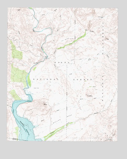
Chalk Mountain, AZ USGS Topographic Map
Click on map above to begin viewing in our Map Viewer.

This topographic map contains these locations and features:
Feature Name Type Latitude Longitude GNIS ID View Map
Andrea SpringSpringN34.0019°W111.6348°41933View Map
Chalk MountainSummitN34.0345°W111.7099°27483View Map
Deadman CreekStreamN34.0009°W111.7107°28334View Map
Dry WashStreamN34.0992°W111.6990°28647View Map
Dutchman Grave SpringSpringN34.1158°W111.6425°28702View Map
H K MesaSummitN34.0948°W111.6871°29642View Map
H K RanchLocaleN34.0964°W111.6696°38487View Map
Hell CanyonValleyN34.0311°W111.7457°29857View Map
Horse CreekStreamN34.0778°W111.7057°30138View Map
Horse MountainSummitN34.0425°W111.6582°30153View Map
Horseshoe ReservoirReservoirN34.0085°W111.7268°30197View Map
Ister FlatFlatN34.0495°W111.7176°30437View Map
JS RanchLocaleN34.0511°W111.6543°38532View Map
Lower Dutchman Grave SpringSpringN34.1153°W111.6483°41936View Map
Manterola SpringSpringN34.1041°W111.6603°41935View Map
Mullen MesaSummitN34.0214°W111.6871°32178View Map
Mullen WashStreamN34.0131°W111.7218°32180View Map
Sheep BridgeBridgeN34.0775°W111.7082°34321View Map
Sheep Bridge Recreation SiteLocaleN34.0770°W111.7101°41934View Map
Spring WashStreamN34.1159°W111.7154°34744View Map
Sycamore CreekStreamN34.0786°W111.7051°35031View Map
Tangle CreekStreamN34.0848°W111.7107°35119View Map
Tangle PeakSummitN34.1225°W111.7396°35121View Map
The White BluffsCliffN34.1025°W111.6999°1852418View Map
Verde River Trail Number ElevenTrailN34.1184°W111.7040°38915View Map

Note: Coordinates in the location and feature list above are referenced to NAD83 datum.


Copyright (C) 2008-2025 Ryan Niemi / Sunset Dynamics ... All Rights Reserved