TopoQuest Logo
Do you find TopoQuest useful?
Help keep TopoQuest running and adding new maps/features by donating!
Bitcoin:  19c7KJd3qBynnjoSw5npx9KScwjBe4ifkT
Litecoin:  LXs6TkuXGGXo1vDsWCkWVdjQX94eUKd6ui
Home View Maps Find Maps Find Places Resources & Links


Table Mountain, Arizona Topographic Map

USGS Map Title: Table Mountain, AZ
USGS Map MRC: 34111A5
DRG (GeoTIFF) Download: o34111a5.tif


Neighboring USGS Topographic Map Quads:


  Wet Bottom Mesa, AZ  
34111B6
 

  Cypress Butte, AZ  
34111B5
 

  North Peak, AZ  
34111B4
 

  Chalk Mountain, AZ  
34111A6
 

  Table Mountain, AZ  
34111A5
 

  Mazatzal Peak, AZ  
34111A4
 

  Horseshoe Dam, AZ  
33111H6
 

  Lion Mountain, AZ  
33111H5
 

  Reno Pass, AZ  
33111H4


Map MRC Location:

N35°
W112°
N35°
W111°
H8 H7 H6 H5 H4 H3 H2 H1
G8 G7 G6 G5 G4 G3 G2 G1
F8 F7 F6 F5 F4 F3 F2 F1
E8 E7 E6 E5 E4 E3 E2 E1
D8 D7 D6 D5 D4 D3 D2 D1
C8 C7 C6 C5 C4 C3 C2 C1
B8 B7 B6 B5 B4 B3 B2 B1
A8 A7 A6 A5 A4 A3 A2 A1
N34°
W112°
N34°
W111°

Table Mountain, AZ USGS 1:24K Topographic Map Preview:
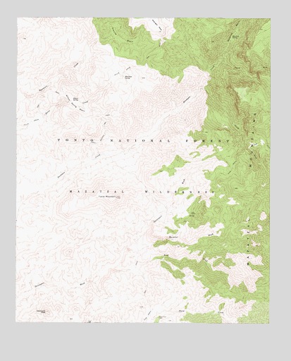
Table Mountain, AZ USGS Topographic Map
Click on map above to begin viewing in our Map Viewer.

This topographic map contains these locations and features:
Feature Name Type Latitude Longitude GNIS ID View Map
Bear CreekStreamN34.0228°W111.5776°26082View Map
Club RanchLocaleN34.0450°W111.5393°27745View Map
Club Ranch TrailTrailN34.0450°W111.5393°27746View Map
Davenport PeakSummitN34.0045°W111.6101°28289View Map
Divide SpringSpringN34.0718°W111.5246°40904View Map
Dog SpringSpringN34.0365°W111.5822°40792View Map
Granite BasinBasinN34.1167°W111.5743°5235View Map
Lost SpringSpringN34.1054°W111.5568°40785View Map
Maverick BasinBasinN34.1203°W111.5188°31572View Map
Maverick SpringSpringN34.1173°W111.5198°31589View Map
Mazatzal WashStreamN34.0306°W111.5668°31616View Map
Mesquite SpringSpringN34.0597°W111.5688°40783View Map
Midway SpringSpringN34.0267°W111.5897°40791View Map
Mountain SpringSpringN34.1009°W111.5727°32081View Map
North Fork Deadman CreekStreamN34.1073°W111.5232°32364View Map
Red Rock SpringSpringN34.0518°W111.5354°40788View Map
Rock SpringSpringN34.0423°W111.5618°40782View Map
Round SpringSpringN34.0008°W111.5575°40789View Map
Sheep Creek CabinLocaleN34.0025°W111.5554°34329View Map
South Fork Deadman CreekStreamN34.0961°W111.5329°34658View Map
Table MountainSummitN34.0514°W111.5760°35092View Map
Table Mountain TrailTrailN34.0789°W111.5818°35103View Map
Wash SpringSpringN34.0188°W111.5851°40790View Map
Willow SpringSpringN34.0908°W111.5983°40784View Map
Willow Spring BasinBasinN34.0895°W111.5965°36262View Map
Willow Spring TrailTrailN34.1039°W111.5640°36274View Map

Note: Coordinates in the location and feature list above are referenced to NAD83 datum.


Copyright (C) 2008-2024 Ryan Niemi / Sunset Dynamics ... All Rights Reserved