TopoQuest Logo
Do you find TopoQuest useful?
Help keep TopoQuest running and adding new maps/features by donating!
Bitcoin:  19c7KJd3qBynnjoSw5npx9KScwjBe4ifkT
Litecoin:  LXs6TkuXGGXo1vDsWCkWVdjQX94eUKd6ui
Home View Maps Find Maps Find Places Resources & Links


Chelsea, Oklahoma Topographic Map

USGS Map Title: Chelsea, OK
USGS Map MRC: 36095E4
DRG (GeoTIFF) Download: o36095e4.tif


Neighboring USGS Topographic Map Quads:


  Nowata East, OK  
36095F5
 

  Chelsea NW, OK  
36095F4
 

  Estella, OK  
36095F3
 

  Winganon, OK  
36095E5
 

  Chelsea, OK  
36095E4
 

  White Oak, OK  
36095E3
 

  Foyil, OK  
36095D5
 

  Bushyhead, OK  
36095D4
 

  Adair, OK  
36095D3


Map MRC Location:

N37°
W96°
N37°
W95°
H8 H7 H6 H5 H4 H3 H2 H1
G8 G7 G6 G5 G4 G3 G2 G1
F8 F7 F6 F5 F4 F3 F2 F1
E8 E7 E6 E5 E4 E3 E2 E1
D8 D7 D6 D5 D4 D3 D2 D1
C8 C7 C6 C5 C4 C3 C2 C1
B8 B7 B6 B5 B4 B3 B2 B1
A8 A7 A6 A5 A4 A3 A2 A1
N36°
W96°
N36°
W95°

Chelsea, OK USGS 1:24K Topographic Map Preview:
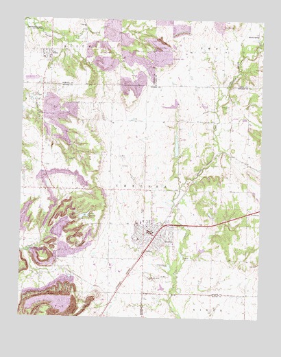
Chelsea, OK USGS Topographic Map
Click on map above to begin viewing in our Map Viewer.

This topographic map contains these locations and features:
Feature Name Type Latitude Longitude GNIS ID View Map
AlluwePopulated PlaceN36.6104°W95.4872°1102839View Map
Art Goad Elementary SchoolSchoolN36.5414°W95.4373°2712967View Map
Bowlin SpringPopulated PlaceN36.6190°W95.3778°1100227View Map
Bowlin Springs Fire DepartmentBuildingN36.6172°W95.3772°2657249View Map
ChelseaPopulated PlaceN36.5356°W95.4325°1091232View Map
Chelsea CemeteryCemeteryN36.5448°W95.4361°1091233View Map
Chelsea DivisionCivilN36.5354°W95.4802°1937668View Map
Chelsea Fire DepartmentBuildingN36.5365°W95.4295°2656867View Map
Chelsea High SchoolSchoolN36.5401°W95.4392°1803894View Map
Chelsea Memorial United Methodist ChurchChurchN36.5376°W95.4355°1782652View Map
Chelsea Middle SchoolSchoolN36.5399°W95.4392°1803893View Map
Chelsea Police DepartmentBuildingN36.5367°W95.4328°2757443View Map
Chelsea ReservoirReservoirN36.5427°W95.4668°1091234View Map
Chelsea Reservoir Number 1ReservoirN36.5434°W95.4586°1751535View Map
Chelsea Reservoir Number 1 DamDamN36.5434°W95.4586°1751534View Map
Chelsea Reservoir Number 2ReservoirN36.5335°W95.4501°1751533View Map
Chelsea Reservoir Number 2 DamDamN36.5334°W95.4503°1751532View Map
Fairview ChurchChurchN36.6226°W95.4680°1092731View Map
First Baptist ChurchChurchN36.5387°W95.4341°1782653View Map
McIntosh Elementary SchoolSchoolN36.5327°W95.4383°2713148View Map
Monarch Field (historical)AirportN36.5251°W95.4669°1102402View Map
New Alluwe Fire DepartmentBuildingN36.6123°W95.4862°2657383View Map
Pryor Creek Number 15 DamDamN36.5118°W95.4236°1754809View Map
Pryor Creek Number 15 ReservoirReservoirN36.5126°W95.4259°1754810View Map
Pryor Creek Number 20 DamDamN36.5901°W95.4053°1754811View Map
Pryor Creek Number 20 ReservoirReservoirN36.5893°W95.4054°1754812View Map
Pryor Creek Watershed Site 19 DamDamN36.5884°W95.4186°1755320View Map
Pryor Creek Watershed Site 19 ReservoirReservoirN36.5886°W95.4232°1755321View Map
Pryor Creek Watershed Site 24 DamDamN36.5301°W95.4069°1755322View Map
Pryor Creek Watershed Site 24 ReservoirReservoirN36.5287°W95.4051°1755323View Map
Shady Grove CemeteryCemeteryN36.5898°W95.3944°1097938View Map
Snider CemeteryCemeteryN36.5395°W95.4044°1098166View Map
Town of ChelseaCivilN36.5323°W95.4355°2413192View Map
Town of New AlluweCivilN36.6100°W95.4887°2413041View Map
Township of ChelseaCivilN36.5537°W95.4355°1824523View Map
United Pentecostal ChurchChurchN36.5368°W95.4266°1782654View Map

Note: Coordinates in the location and feature list above are referenced to NAD83 datum.


Copyright (C) 2008-2024 Ryan Niemi / Sunset Dynamics ... All Rights Reserved