TopoQuest Logo
Do you find TopoQuest useful?
Help keep TopoQuest running and adding new maps/features by donating!
Bitcoin:  19c7KJd3qBynnjoSw5npx9KScwjBe4ifkT
Litecoin:  LXs6TkuXGGXo1vDsWCkWVdjQX94eUKd6ui
Home View Maps Find Maps Find Places Resources & Links


Chester Gap, Virginia Topographic Map

USGS Map Title: Chester Gap, VA
USGS Map MRC: 38078G2
DRG (GeoTIFF) Download: o38078g2.tif


Neighboring USGS Topographic Map Quads:


  Strasburg, VA  
38078H3
 

  Front Royal, VA  
38078H2
 

  Linden, VA  
38078H1
 

  Bentonville, VA  
38078G3
 

  Chester Gap, VA  
38078G2
 

  Flint Hill, VA  
38078G1
 

  Thornton Gap, VA  
38078F3
 

  Washington, VA  
38078F2
 

  Massies Corner, VA  
38078F1


Map MRC Location:

N39°
W79°
N39°
W78°
H8 H7 H6 H5 H4 H3 H2 H1
G8 G7 G6 G5 G4 G3 G2 G1
F8 F7 F6 F5 F4 F3 F2 F1
E8 E7 E6 E5 E4 E3 E2 E1
D8 D7 D6 D5 D4 D3 D2 D1
C8 C7 C6 C5 C4 C3 C2 C1
B8 B7 B6 B5 B4 B3 B2 B1
A8 A7 A6 A5 A4 A3 A2 A1
N38°
W79°
N38°
W78°

Chester Gap, VA USGS 1:24K Topographic Map Preview:
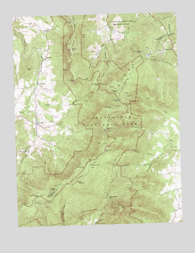
Chester Gap, VA USGS Topographic Map
Click on map above to begin viewing in our Map Viewer.

This topographic map contains these locations and features:
Feature Name Type Latitude Longitude GNIS ID View Map
ArcoPopulated PlaceN38.8601°W78.1747°1492480View Map
Bearwallow CreekStreamN38.7940°W78.1369°1462912View Map
Big Devils Stairs TrailTrailN38.7526°W78.2161°1463345View Map
Blue Ridge Mountains EstatesPopulated PlaceN38.8523°W78.1506°1492594View Map
Bluff TrailTrailN38.7668°W78.1967°1463610View Map
Bolton BranchStreamN38.7940°W78.1369°1463650View Map
Bonnie GlenLocaleN38.8182°W78.2333°1674074View Map
Boyds MillPopulated PlaceN38.8348°W78.2317°1477136View Map
Broad RunStreamN38.8071°W78.2347°1463849View Map
BrowntownPopulated PlaceN38.8109°W78.2336°1492645View Map
Browntown Baptist ChurchChurchN38.8112°W78.2331°1674076View Map
Browntown ChurchChurchN38.7957°W78.2425°1463936View Map
Browntown Valley OverlookLocaleN38.7846°W78.1978°1463937View Map
Buck MountainSummitN38.8440°W78.2392°1463991View Map
Carson MountainSummitN38.8294°W78.1707°1492720View Map
Chester GapPopulated PlaceN38.8534°W78.1350°1492755View Map
Chester GapGapN38.8621°W78.1303°1464799View Map
Chester Gap Census Designated PlaceCensusN38.8534°W78.1325°2630625View Map
Chester Gap Volunteer Fire DepartmentBuildingN38.8515°W78.1358°2075154View Map
Compton GapGapN38.8237°W78.1706°1465148View Map
Compton PeakSummitN38.8190°W78.1750°1465150View Map
Curl FarmLocaleN38.8521°W78.2475°1674091View Map
Dickey HillSummitN38.8546°W78.2056°1465774View Map
Dickey Hill TrailTrailN38.8487°W78.2042°1465775View Map
Dickey RidgeRidgeN38.8572°W78.2052°1465777View Map
Dickey Ridge Visitor CenterLocaleN38.8718°W78.2042°1465778View Map
Front Royal-Warren County AmphitheaterLocaleN38.8629°W78.1692°1674107View Map
Gimlet Ridge OverlookLocaleN38.7635°W78.2456°1467109View Map
Glen EchoPopulated PlaceN38.8501°W78.2244°1493002View Map
Glenn Manor Tree FarmLocaleN38.8284°W78.2314°1674109View Map
Glenway FarmLocaleN38.8409°W78.2247°1674110View Map
Gooney Creek Tree FarmLocaleN38.8084°W78.2411°1674112View Map
Gooney Manor OverlookLocaleN38.8365°W78.2031°1467243View Map
Gooney Run OverlookLocaleN38.8423°W78.2069°1467244View Map
Gravel Springs GapGapN38.7679°W78.2333°1467395View Map
Gravel Springs ShelterLocaleN38.7640°W78.2336°1467396View Map
Greasy RunStreamN38.8243°W78.2383°1483782View Map
Harmony HollowValleyN38.8553°W78.1801°1467758View Map
Harmony Hollow OrchardWoodsN38.8623°W78.1792°1674122View Map
Harmony Hollow School (historical)SchoolN38.8548°W78.1797°1674031View Map
Hickerson HollowValleyN38.8554°W78.1800°1467974View Map
Hogwallow FlatFlatN38.7851°W78.1928°1468122View Map
Hogwallow Flat OverlookLocaleN38.7937°W78.1817°1468123View Map
Indian Run OverlookLocaleN38.8212°W78.1647°1468487View Map
Indian Run ShelterLocaleN38.8262°W78.1639°1468488View Map
Jenkins GapGapN38.8073°W78.1806°1468673View Map
Jenkins Gap OverlookLocaleN38.8057°W78.1803°1468674View Map
Joy SpringPopulated PlaceN38.8604°W78.1506°1674136View Map
Lake CulpeperReservoirN38.8603°W78.1698°1674090View Map
Lake Front RoyalPopulated PlaceN38.8693°W78.1489°1674139View Map
Lands RunStreamN38.8293°W78.2353°1469122View Map
Lands Run GapGapN38.8343°W78.1853°1469123View Map
Laureldale School (historical)SchoolN38.7896°W78.1356°1673969View Map
Liberty HallBuildingN38.8323°W78.2256°1674140View Map
Long ArmRidgeN38.7766°W78.2230°1469751View Map
Low GapGapN38.8362°W78.1939°1469894View Map
Miller FallsFallsN38.7811°W78.2082°2770925View Map
Moore RunStreamN38.8671°W78.1747°1470713View Map
Mount MarshallSummitN38.7759°W78.2027°1493255View Map
North MarshallSummitN38.7760°W78.2027°1471627View Map
Northern Virginia 4 - H Educational CenterSchoolN38.8592°W78.1721°1674162View Map
Phils Arm RunStreamN38.7968°W78.2392°1472261View Map
Point O'WoodsPopulated PlaceN38.8743°W78.1356°1674164View Map
Poor House FarmLocaleN38.8687°W78.2225°1674165View Map
Range View OverlookLocaleN38.7640°W78.2269°1472971View Map
Sea LockPopulated PlaceN38.8676°W78.1369°1674178View Map
Shenandoah Homesteads ProjectPopulated PlaceN38.7796°W78.1292°1673984View Map
Signal Knob OverlookLocaleN38.8584°W78.2089°1474583View Map
Skyline View Mobile Home ParkPopulated PlaceN38.8009°W78.2247°1674187View Map
Smith CreekStreamN38.8182°W78.2353°1474747View Map
South MarshallSummitN38.7721°W78.2203°1474874View Map
South River Primitive Baptist ChurchChurchN38.8121°W78.2331°1674188View Map
South Warren Volunteer Fire Department Brownstown SubstationBuildingN38.8122°W78.2326°2721127View Map
Sprucepine BranchStreamN38.7857°W78.1478°1475035View Map
Sullivan LakeReservoirN38.8701°W78.2214°1490995View Map
Sullivans DamDamN38.8701°W78.2214°1490994View Map
SundownLocaleN38.7912°W78.2203°1674191View Map
The CoveLocaleN38.8718°W78.2164°1674195View Map
The PeakSummitN38.7603°W78.1716°1475599View Map
The Peak TrailTrailN38.7623°W78.1767°1475600View Map
Thoroughfare GapGapN38.7662°W78.1808°1475686View Map
Triple M FarmLocaleN38.8004°W78.2372°1674198View Map
Vaughan Archery RangeLocaleN38.8626°W78.1672°1674201View Map
Waterfall BranchStreamN38.7890°W78.1431°1476370View Map
Williams CemeteryCemeteryN38.8507°W78.1367°1476758View Map

Note: Coordinates in the location and feature list above are referenced to NAD83 datum.


Copyright (C) 2008-2025 Ryan Niemi / Sunset Dynamics ... All Rights Reserved