TopoQuest Logo
Do you find TopoQuest useful?
Help keep TopoQuest running and adding new maps/features by donating!
Bitcoin:  19c7KJd3qBynnjoSw5npx9KScwjBe4ifkT
Litecoin:  LXs6TkuXGGXo1vDsWCkWVdjQX94eUKd6ui
Home View Maps Find Maps Find Places Resources & Links


Washington, Virginia Topographic Map

USGS Map Title: Washington, VA
USGS Map MRC: 38078F2
DRG (GeoTIFF) Download: o38078f2.tif


Neighboring USGS Topographic Map Quads:


  Bentonville, VA  
38078G3
 

  Chester Gap, VA  
38078G2
 

  Flint Hill, VA  
38078G1
 

  Thornton Gap, VA  
38078F3
 

  Washington, VA  
38078F2
 

  Massies Corner, VA  
38078F1
 

  Old Rag Mountain, VA  
38078E3
 

  Woodville, VA  
38078E2
 

  Castleton, VA  
38078E1


Map MRC Location:

N39°
W79°
N39°
W78°
H8 H7 H6 H5 H4 H3 H2 H1
G8 G7 G6 G5 G4 G3 G2 G1
F8 F7 F6 F5 F4 F3 F2 F1
E8 E7 E6 E5 E4 E3 E2 E1
D8 D7 D6 D5 D4 D3 D2 D1
C8 C7 C6 C5 C4 C3 C2 C1
B8 B7 B6 B5 B4 B3 B2 B1
A8 A7 A6 A5 A4 A3 A2 A1
N38°
W79°
N38°
W78°

Washington, VA USGS 1:24K Topographic Map Preview:
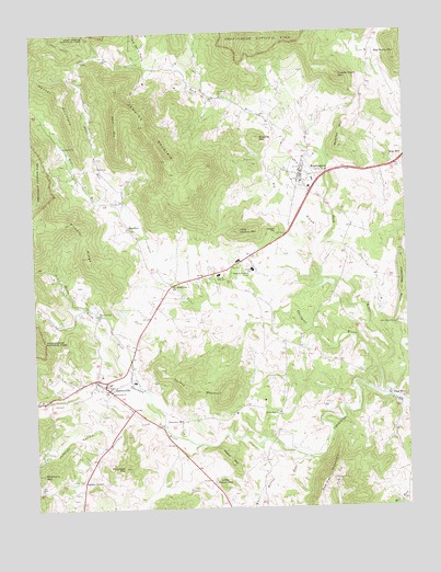
Washington, VA USGS Topographic Map
Click on map above to begin viewing in our Map Viewer.

This topographic map contains these locations and features:
Feature Name Type Latitude Longitude GNIS ID View Map
Ashbys CornerPopulated PlaceN38.6321°W78.2342°1499066View Map
Beaverdam CreekStreamN38.6465°W78.2061°1462965View Map
Big BranchStreamN38.6935°W78.1533°1463324View Map
Big Devils StairsValleyN38.7440°W78.2117°1463344View Map
Big Mulky MountainSummitN38.7423°W78.1261°1463388View Map
Covington RiverStreamN38.6615°W78.1344°1465337View Map
First Baptist Church of WashingtonChurchN38.7171°W78.1586°1673959View Map
Five ForksPopulated PlaceN38.6501°W78.1683°1499418View Map
Five Forks Regular Baptist ChurchChurchN38.6501°W78.1681°1673960View Map
Fletcher MillPopulated PlaceN38.6473°W78.2064°1499426View Map
Fodder Stack MountainSummitN38.7378°W78.1464°1499429View Map
Ginger HillSummitN38.6978°W78.1677°1499474View Map
Gravel Springs TrailTrailN38.7496°W78.2414°1467397View Map
Hampton DistrictCivilN38.7222°W78.1494°1927333View Map
Jenkins HollowValleyN38.6470°W78.2305°1468675View Map
Jenkins MountainSummitN38.7256°W78.2117°1468676View Map
Keyser MountainSummitN38.7357°W78.2403°1499625View Map
Keyser RunStreamN38.7054°W78.2206°1484578View Map
Little Jenkins MountainSummitN38.6979°W78.1804°1469577View Map
Little Mason MountainSummitN38.6315°W78.1872°1499671View Map
Margolis DamDamN38.6835°W78.1497°1490778View Map
Margolis PondReservoirN38.6843°W78.1520°1490779View Map
Mason MountainSummitN38.6365°W78.1834°1470160View Map
Massies MountainSummitN38.7221°W78.1736°1499712View Map
Menefee MountainSummitN38.7195°W78.1470°1470358View Map
New Salem ChurchChurchN38.6729°W78.1289°1471496View Map
North Fork Thornton RiverStreamN38.6573°W78.2153°1471622View Map
Oakley ChurchChurchN38.7204°W78.2383°1471788View Map
Old School ChurchChurchN38.7332°W78.1850°1471874View Map
Pickerel RidgeRidgeN38.7003°W78.2411°1472268View Map
Piney RiverStreamN38.6782°W78.2331°1486269View Map
Poortown MountainSummitN38.6361°W78.2204°1472621View Map
Promise Land Baptist ChurchChurchN38.6965°W78.2150°1673975View Map
Racer RunStreamN38.7054°W78.2203°1472924View Map
Rappahannock CountyCivilN38.6848°W78.1592°1673976View Map
Rappahannock County High SchoolSchoolN38.6864°W78.1877°1673977View Map
Rappahannock County LibraryBuildingN38.7146°W78.1589°1673978View Map
Rappahannock County Sheriff's OfficeBuildingN38.7108°W78.1594°2086044View Map
Rappahannock County Sheriff's OfficeBuildingN38.7107°W78.1593°2332088View Map
Rappahannock Elementary SchoolSchoolN38.6877°W78.1762°1673979View Map
Rappahannock Medical ClinicHospitalN38.7132°W78.1589°1673980View Map
Red Oak MountainSummitN38.6323°W78.1499°1499941View Map
RedivivaPopulated PlaceN38.6848°W78.2019°1499942View Map
Redmans MountainSummitN38.6347°W78.2477°1473079View Map
Reynolds ChurchChurchN38.6551°W78.2239°1473165View Map
Rock MillsPopulated PlaceN38.6551°W78.1294°1499980View Map
Rose HillPopulated PlaceN38.7165°W78.1253°1499985View Map
Rudasills Mill (historical)LocaleN38.6418°W78.1689°1673983View Map
Rush RiverStreamN38.6543°W78.1306°1473641View Map
SmedleyPopulated PlaceN38.6985°W78.2167°1500122View Map
SperryvillePopulated PlaceN38.6571°W78.2261°1500138View Map
Sperryville Census Designated PlaceCensusN38.6562°W78.2322°2629040View Map
Sperryville Historic DistrictParkN38.6576°W78.2267°1673987View Map
Sperryville Post OfficePost OfficeN38.6581°W78.2274°2766297View Map
Sperryville Volunteer Fire DepartmentBuildingN38.6565°W78.2391°2331765View Map
Sperryville Volunteer Rescue SquadBuildingN38.6588°W78.2302°2331790View Map
The Washington Academy (historical)SchoolN38.7160°W78.1583°1673990View Map
Thornton Gap ChurchChurchN38.6771°W78.2278°1475668View Map
Thorntons Gap Regular Baptist ChurchChurchN38.6754°W78.2283°1673991View Map
Town of WashingtonCivilN38.7121°W78.1598°2391471View Map
Trinity Episcopal ChurchChurchN38.7132°W78.1594°1673992View Map
Turkey MountainSummitN38.6547°W78.1864°1500244View Map
WashingtonPopulated PlaceN38.7135°W78.1594°1500280View Map
Washington Baptist ChurchChurchN38.7107°W78.1594°1673994View Map
Washington Female Academy (historical)SchoolN38.7132°W78.1589°1673995View Map
Washington Historic DistrictParkN38.7135°W78.1594°1673996View Map
Washington Methodist Church (historical)ChurchN38.7121°W78.1592°1673997View Map
Washington Post OfficePost OfficeN38.7135°W78.1602°2766319View Map
Washington Presbyterian Church (historical)ChurchN38.7146°W78.1589°1673998View Map
Washington Volunteer Fire and RescueBuildingN38.7137°W78.1540°2331764View Map
Whippoorwill DamDamN38.7068°W78.1731°1490776View Map
Whippoorwill PondReservoirN38.7068°W78.1731°1490777View Map
White Walnut RunStreamN38.6382°W78.1569°1476650View Map
Wolf MountainSummitN38.7299°W78.2208°1500341View Map

Note: Coordinates in the location and feature list above are referenced to NAD83 datum.


Copyright (C) 2008-2024 Ryan Niemi / Sunset Dynamics ... All Rights Reserved