TopoQuest Logo
Do you find TopoQuest useful?
Help keep TopoQuest running and adding new maps/features by donating!
Bitcoin:  19c7KJd3qBynnjoSw5npx9KScwjBe4ifkT
Litecoin:  LXs6TkuXGGXo1vDsWCkWVdjQX94eUKd6ui
Home View Maps Find Maps Find Places Resources & Links


Chicos Well, Colorado Topographic Map

USGS Map Title: Chicos Well, CO
USGS Map MRC: 38104A3
DRG (GeoTIFF) Download: o38104a3.tif


Neighboring USGS Topographic Map Quads:


  Vineland, CO  
38104B4
 

  Avondale, CO  
38104B3
 

  Nepesta, CO  
38104B2
 

  Doyle Bridge, CO  
38104A4
 

  Chicos Well, CO  
38104A3
 

  Flying A Ranch, CO  
38104A2
 

  Hog Ranch Canyon, CO  
37104H4
 

  Red Top Ranch, CO  
37104H3
 

  Yellowbank Creek, CO  
37104H2


Map MRC Location:

N39°
W105°
N39°
W104°
H8 H7 H6 H5 H4 H3 H2 H1
G8 G7 G6 G5 G4 G3 G2 G1
F8 F7 F6 F5 F4 F3 F2 F1
E8 E7 E6 E5 E4 E3 E2 E1
D8 D7 D6 D5 D4 D3 D2 D1
C8 C7 C6 C5 C4 C3 C2 C1
B8 B7 B6 B5 B4 B3 B2 B1
A8 A7 A6 A5 A4 A3 A2 A1
N38°
W105°
N38°
W104°

Chicos Well, CO USGS 1:24K Topographic Map Preview:
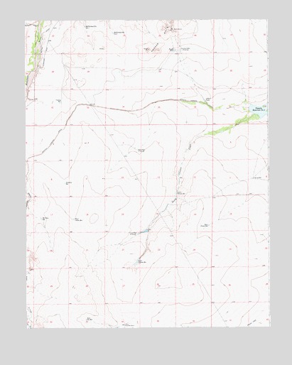
Chicos Well, CO USGS Topographic Map
Click on map above to begin viewing in our Map Viewer.

This topographic map contains these locations and features:
Feature Name Type Latitude Longitude GNIS ID View Map
Alderd TankReservoirN38.0922°W104.2829°193863View Map
Alderd WellWellN38.0720°W104.3175°193867View Map
Chicosa Number 5 DamDamN38.0900°W104.2505°200974View Map
Double TankReservoirN38.1129°W104.2978°193861View Map
Doyle Arroya Feeder DitchCanalN38.0504°W104.3688°2712009View Map
East Chicos ReservoirReservoirN38.0414°W104.2814°193873View Map
East Cox ReservoirReservoirN38.0033°W104.3445°193870View Map
East Cox WindmillLocaleN38.0011°W104.3244°193871View Map
Fountain WellWellN38.1131°W104.2950°193862View Map
Fourmile CreekStreamN38.1233°W104.3680°193810View Map
Goodwin ReservoirReservoirN38.0622°W104.3550°193864View Map
Huerfano Valley DivisionCivilN38.0024°W104.3248°1935488View Map
Long DrawValleyN38.0052°W104.3729°193972View Map
Lower Chicosa ReservoirReservoirN38.0548°W104.2979°193868View Map
McFarland Reservoir Number 1ReservoirN38.1222°W104.3439°193859View Map
McFarland Reservoir Number 2ReservoirN38.1196°W104.3295°193860View Map
Nepesta Farmers DitchCanalN38.0858°W104.3283°203701View Map
Nepesta Reservoir Number 5ReservoirN38.0879°W104.2523°169528View Map
Upper Chicosa ReservoirReservoirN38.0267°W104.3185°193872View Map
West Chicos ReservoirReservoirN38.0441°W104.3502°193866View Map

Note: Coordinates in the location and feature list above are referenced to NAD83 datum.


Copyright (C) 2008-2025 Ryan Niemi / Sunset Dynamics ... All Rights Reserved