TopoQuest Logo
Do you find TopoQuest useful?
Help keep TopoQuest running and adding new maps/features by donating!
Bitcoin:  19c7KJd3qBynnjoSw5npx9KScwjBe4ifkT
Litecoin:  LXs6TkuXGGXo1vDsWCkWVdjQX94eUKd6ui
Home View Maps Find Maps Find Places Resources & Links


Christine, North Dakota Topographic Map

USGS Map Title: Christine, ND
USGS Map MRC: 46096E7
DRG (GeoTIFF) Download: o46096e7.tif


Neighboring USGS Topographic Map Quads:


  Norman, ND  
46096F8
 

  Hickson, ND  
46096F7
 

  Comstock, MN  
46096F6
 

  Walcott, ND  
46096E8
 

  Christine, ND  
46096E7
 

  Wolverton, MN  
46096E6
 

  Mooreton NW, ND  
46096D8
 

  Galchutt, ND  
46096D7
 

  Abercrombie, ND  
46096D6


Map MRC Location:

N47°
W97°
N47°
W96°
H8 H7 H6 H5 H4 H3 H2 H1
G8 G7 G6 G5 G4 G3 G2 G1
F8 F7 F6 F5 F4 F3 F2 F1
E8 E7 E6 E5 E4 E3 E2 E1
D8 D7 D6 D5 D4 D3 D2 D1
C8 C7 C6 C5 C4 C3 C2 C1
B8 B7 B6 B5 B4 B3 B2 B1
A8 A7 A6 A5 A4 A3 A2 A1
N46°
W97°
N46°
W96°

Christine, ND USGS 1:24K Topographic Map Preview:
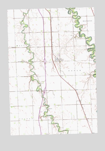
Christine, ND USGS Topographic Map
Click on map above to begin viewing in our Map Viewer.

This topographic map contains these locations and features:
Feature Name Type Latitude Longitude GNIS ID View Map
ChristinePopulated PlaceN46.5736°W96.8017°1028370View Map
Christine CemeteryCemeteryN46.5716°W96.8120°1028371View Map
Christine City HallBuildingN46.5750°W96.8049°2744104View Map
Christine Community CenterBuildingN46.5750°W96.8049°2746013View Map
Christine Community Fire DistrictBuildingN46.5745°W96.8053°2637540View Map
Christine DamDamN46.5933°W96.7770°1033199View Map
Christine Post OfficePost OfficeN46.5749°W96.8053°2741938View Map
City of ChristineCivilN46.5751°W96.8063°1035969View Map
Eagle CemeteryCemeteryN46.5764°W96.7587°1028756View Map
Flying-N-Ranch Airport (historical)AirportN46.5496°W96.7888°2650634View Map
LithiaPopulated PlaceN46.6161°W96.8134°1033773View Map
Pioneer CemeteryCemeteryN46.5975°W96.7806°1030716View Map
Pleasant SchoolSchoolN46.5875°W96.8642°1030749View Map
Richland CemeteryCemeteryN46.5001°W96.8047°1030902View Map
Richland ChurchChurchN46.5252°W96.8209°1030904View Map
South Pleasant CemeteryCemeteryN46.5868°W96.8338°1032199View Map
South Pleasant ChurchChurchN46.5730°W96.8537°1032200View Map
Township of EagleCivilN46.5323°W96.7822°1036853View Map

Note: Coordinates in the location and feature list above are referenced to NAD83 datum.


Copyright (C) 2008-2025 Ryan Niemi / Sunset Dynamics ... All Rights Reserved