TopoQuest Logo
Do you find TopoQuest useful?
Help keep TopoQuest running and adding new maps/features by donating!
Bitcoin:  19c7KJd3qBynnjoSw5npx9KScwjBe4ifkT
Litecoin:  LXs6TkuXGGXo1vDsWCkWVdjQX94eUKd6ui
Home View Maps Find Maps Find Places Resources & Links


Chuckey, Tennessee Topographic Map

USGS Map Title: Chuckey, TN
USGS Map MRC: 36082B6
DRG (GeoTIFF) Download: o36082b6.tif


Neighboring USGS Topographic Map Quads:


  Baileyton, TN  
36082C7
 

  Jearoldstown, TN  
36082C6
 

  Leesburg, TN  
36082C5
 

  Greeneville, TN  
36082B7
 

  Chuckey, TN  
36082B6
 

  Telford, TN  
36082B5
 

  Davy Crockett Lake, TN  
36082A7
 

  Greystone, TN  
36082A6
 

  Flag Pond, TN  
36082A5


Map MRC Location:

N37°
W83°
N37°
W82°
H8 H7 H6 H5 H4 H3 H2 H1
G8 G7 G6 G5 G4 G3 G2 G1
F8 F7 F6 F5 F4 F3 F2 F1
E8 E7 E6 E5 E4 E3 E2 E1
D8 D7 D6 D5 D4 D3 D2 D1
C8 C7 C6 C5 C4 C3 C2 C1
B8 B7 B6 B5 B4 B3 B2 B1
A8 A7 A6 A5 A4 A3 A2 A1
N36°
W83°
N36°
W82°

Chuckey, TN USGS 1:24K Topographic Map Preview:
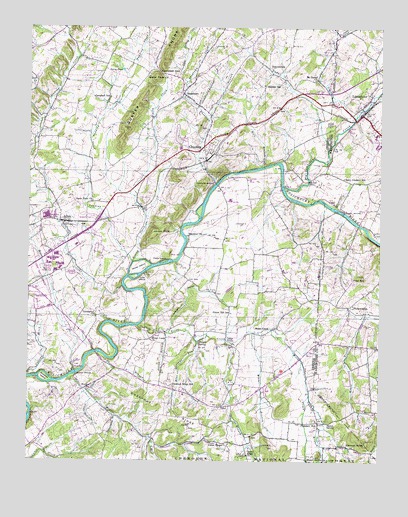
Chuckey, TN USGS Topographic Map
Click on map above to begin viewing in our Map Viewer.

This topographic map contains these locations and features:
Feature Name Type Latitude Longitude GNIS ID View Map
AftonPopulated PlaceN36.1940°W82.7388°1304773View Map
Afton Post OfficePost OfficeN36.1934°W82.7375°1649899View Map
Afton United Methodist ChurchChurchN36.1926°W82.7343°1320052View Map
Alexander BranchStreamN36.1595°W82.6785°1327449View Map
Berry PondLakeN36.2379°W82.7168°1277061View Map
Big Limestone CreekStreamN36.2043°W82.6599°1326906View Map
Blaines ShoalsBarN36.2001°W82.6454°1643133View Map
Blue Springs BranchStreamN36.1598°W82.6904°1277811View Map
Brown BridgeBridgeN36.1501°W82.7329°1278515View Map
Broyle SpringSpringN36.1587°W82.6896°1278637View Map
Campbell GapGapN36.2376°W82.7043°1279451View Map
Campbell SchoolSchoolN36.2301°W82.7215°1279468View Map
Cane IslandIslandN36.1823°W82.7021°1279537View Map
Cannon BranchStreamN36.1440°W82.6496°1327819View Map
Cannon KnobSummitN36.1304°W82.6293°1279611View Map
Carson CreekStreamN36.2487°W82.6410°1279761View Map
Cedar CreekStreamN36.2162°W82.6426°1280015View Map
Cedar Grove ChurchChurchN36.1582°W82.6782°1305769View Map
Chestnut RidgePopulated PlaceN36.1459°W82.6979°1647160View Map
Chestnut RidgeRidgeN36.1415°W82.7040°1280413View Map
Chestnut Ridge SchoolSchoolN36.1470°W82.6990°1280423View Map
ChuckeyPopulated PlaceN36.2159°W82.6882°1305927View Map
Chuckey-Doak High SchoolSchoolN36.1870°W82.7329°1309256View Map
Chucky Elementary SchoolSchoolN36.2154°W82.6963°1309255View Map
Chucky Post OfficePost OfficeN36.2194°W82.7029°1649903View Map
City of TusculumCivilN36.1751°W82.7454°2405615View Map
College CreekStreamN36.1493°W82.7499°1280963View Map
Commissioner District 2CivilN36.1995°W82.6848°2463923View Map
Corby QuarryMineN36.1903°W82.6306°2633349View Map
Davy Crockett SchoolSchoolN36.2065°W82.6379°1282209View Map
DotsontownPopulated PlaceN36.2384°W82.6654°1314968View Map
Earnest BridgeBridgeN36.2045°W82.6838°1283311View Map
Ebenezer ChurchChurchN36.1901°W82.6938°1283479View Map
F Earnests ShoalsBarN36.1879°W82.6943°1643140View Map
Forest Hill SchoolSchoolN36.1676°W82.6782°1284596View Map
Fox CemeteryCemeteryN36.1770°W82.6929°1641058View Map
Gillespies ShoalsBarN36.2054°W82.6601°1643141View Map
Glaze BridgeBridgeN36.1968°W82.6379°1285493View Map
Glaze CemeteryCemeteryN36.2057°W82.6363°1321295View Map
Grant BranchStreamN36.2237°W82.6868°1285847View Map
Green Ridge ChurchChurchN36.1268°W82.6713°1286120View Map
Greene Valley Developmental CenterHospitalN36.1844°W82.7406°1286163View Map
Greenwood ChurchChurchN36.1665°W82.7260°1286204View Map
H Earnests ShoalsBarN36.2090°W82.6713°1643142View Map
Hall BranchStreamN36.2026°W82.7443°1286555View Map
Henshaw (historical)Populated PlaceN36.1457°W82.7301°1309285View Map
Hensley AirparkAirportN36.1834°W82.6786°2675572View Map
Hermon ChurchChurchN36.1457°W82.7282°1287492View Map
Hice BranchStreamN36.2098°W82.6682°1287531View Map
Horse CreekStreamN36.1640°W82.7113°1328490View Map
Horse CreekPopulated PlaceN36.1629°W82.6632°1315258View Map
Horse Creek ChurchChurchN36.1601°W82.7068°1288398View Map
Horse Creek SpringSpringN36.1607°W82.6671°1643143View Map
Howard ShoalsBarN36.1787°W82.7099°1643144View Map
Jilton BranchStreamN36.1620°W82.7015°1289428View Map
Jockey CreekStreamN36.2245°W82.6340°1289451View Map
Johnson HollowValleyN36.1623°W82.6997°1289619View Map
Jordan KnobSummitN36.1907°W82.7063°1289843View Map
L Earnests ShoalsBarN36.1948°W82.6890°1643148View Map
LimestonePopulated PlaceN36.2282°W82.6304°1291295View Map
Limestone Post OfficePost OfficeN36.2364°W82.6272°1649197View Map
Limestone SchoolSchoolN36.2282°W82.6313°1646769View Map
Limestone Volunteer Fire DepartmentBuildingN36.2248°W82.6316°2654388View Map
Little Sinking CreekStreamN36.2370°W82.6968°1291665View Map
Lost IslandIslandN36.1779°W82.7127°1292085View Map
Miami BranchStreamN36.1623°W82.6699°1293643View Map
Middle CreekStreamN36.1490°W82.7360°1328891View Map
Moon CreekStreamN36.1504°W82.7338°1294223View Map
Mount Bethel ChurchChurchN36.2351°W82.6482°1294556View Map
Oakdale SchoolSchoolN36.2334°W82.6665°1296169View Map
Painter CemeteryCemeteryN36.1620°W82.6457°1321351View Map
Parkland AcresPopulated PlaceN36.1737°W82.7452°1309300View Map
PhiladelphiaPopulated PlaceN36.1698°W82.6365°1315705View Map
Philadelphia CemeteryCemeteryN36.1695°W82.6351°1321353View Map
Philadelphia Cumberland Presbyterian ChurchChurchN36.1695°W82.6343°1321354View Map
Philadelphia School (historical)SchoolN36.1684°W82.6326°1646773View Map
Pilot HillSummitN36.1784°W82.6307°1297478View Map
Pleasant HillPopulated PlaceN36.1357°W82.6465°1315736View Map
Pleasant Hill United Methodist ChurchChurchN36.1370°W82.6638°1320075View Map
Pleasant ViewPopulated PlaceN36.1709°W82.7496°1309303View Map
Pudding CreekStreamN36.1826°W82.7132°1298653View Map
Quaker KnobsRidgeN36.2482°W82.6982°1298733View Map
Quaker Knobs ChurchChurchN36.2362°W82.7082°1298734View Map
RheatownPopulated PlaceN36.2312°W82.6957°1299276View Map
Rheatown CreekStreamN36.2051°W82.6840°1299277View Map
Rheatown-Chucky Division (historical)CensusN36.2279°W82.6915°1648722View Map
Ripley CreekStreamN36.1826°W82.7132°1299473View Map
Ripley IslandIslandN36.1809°W82.7110°1299474View Map
Seaton SpringSpringN36.1362°W82.6429°1301002View Map
Shelton BranchStreamN36.1545°W82.7224°1270010View Map
Simpson IslandIslandN36.1493°W82.7451°1270343View Map
Sinking CreekStreamN36.1754°W82.7168°1303642View Map
Sinking Creek ShoalsBarN36.1757°W82.7157°1643152View Map
Skyles SpringSpringN36.1251°W82.6451°1270457View Map
Stage CreekStreamN36.1426°W82.7274°1271195View Map
Statemount (historical)Populated PlaceN36.2376°W82.7360°1309310View Map
Stone Dam ChurchChurchN36.1998°W82.7277°1303854View Map
Sulphur Spring BranchStreamN36.1382°W82.7188°1271805View Map
Twin Creek Golf CourseLocaleN36.2070°W82.7124°1309320View Map
Union ChapelChurchN36.1295°W82.6796°1304223View Map
Union Chapel School (historical)SchoolN36.1301°W82.6779°1320079View Map
Urbana CemeteryCemeteryN36.2312°W82.6251°1321377View Map
Zion ChurchChurchN36.2351°W82.7482°1275366View Map
Zion School (historical)SchoolN36.1270°W82.7424°1309329View Map

Note: Coordinates in the location and feature list above are referenced to NAD83 datum.


Copyright (C) 2008-2024 Ryan Niemi / Sunset Dynamics ... All Rights Reserved