TopoQuest Logo
Do you find TopoQuest useful?
Help keep TopoQuest running and adding new maps/features by donating!
Bitcoin:  19c7KJd3qBynnjoSw5npx9KScwjBe4ifkT
Litecoin:  LXs6TkuXGGXo1vDsWCkWVdjQX94eUKd6ui
Home View Maps Find Maps Find Places Resources & Links


Baileyton, Tennessee Topographic Map

USGS Map Title: Baileyton, TN
USGS Map MRC: 36082C7
DRG (GeoTIFF) Download: o36082c7.tif


Neighboring USGS Topographic Map Quads:


  Burem, TN  
36082D8
 

  Stony Point, TN  
36082D7
 

  Lovelace, TN  
36082D6
 

  McCloud, TN  
36082C8
 

  Baileyton, TN  
36082C7
 

  Jearoldstown, TN  
36082C6
 

  Mosheim, TN  
36082B8
 

  Greeneville, TN  
36082B7
 

  Chuckey, TN  
36082B6


Map MRC Location:

N37°
W83°
N37°
W82°
H8 H7 H6 H5 H4 H3 H2 H1
G8 G7 G6 G5 G4 G3 G2 G1
F8 F7 F6 F5 F4 F3 F2 F1
E8 E7 E6 E5 E4 E3 E2 E1
D8 D7 D6 D5 D4 D3 D2 D1
C8 C7 C6 C5 C4 C3 C2 C1
B8 B7 B6 B5 B4 B3 B2 B1
A8 A7 A6 A5 A4 A3 A2 A1
N36°
W83°
N36°
W82°

Baileyton, TN USGS 1:24K Topographic Map Preview:
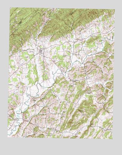
Baileyton, TN USGS Topographic Map
Click on map above to begin viewing in our Map Viewer.

This topographic map contains these locations and features:
Feature Name Type Latitude Longitude GNIS ID View Map
Babbs KnobSummitN36.2615°W82.7943°1276038View Map
Babbs MillPopulated PlaceN36.2637°W82.7771°1314612View Map
Babbs ValleyValleyN36.2514°W82.7997°1276039View Map
Bailey CemeteryCemeteryN36.3348°W82.8468°1276103View Map
BaileytonPopulated PlaceN36.3343°W82.8368°1276120View Map
Baileyton Division (historical)CensusN36.3243°W82.8440°1648717View Map
Baileyton Elementary SchoolSchoolN36.3340°W82.8388°1309214View Map
Baileyton First Baptist ChurchChurchN36.3309°W82.8368°1320053View Map
Baileyton Police DepartmentBuildingN36.3331°W82.8383°2765826View Map
Baileyton United Methodist ChurchChurchN36.3295°W82.8354°1320054View Map
Bright BranchStreamN36.3065°W82.7518°1275385View Map
BrittontownPopulated PlaceN36.2729°W82.7865°1314734View Map
Brittontown SchoolSchoolN36.2765°W82.7863°1278427View Map
Brown MountainSummitN36.3551°W82.8718°1269383View Map
Brown Mountain SchoolSchoolN36.3607°W82.8677°1305455View Map
Caney CreekStreamN36.3223°W82.7990°1269418View Map
Caney Creek CemeteryCemeteryN36.3509°W82.7999°1279567View Map
Caney Creek ChurchChurchN36.3451°W82.7932°1279568View Map
Caney RidgeRidgeN36.3720°W82.7818°1269419View Map
Carter CemeteryCemeteryN36.3006°W82.8713°1279805View Map
Casteel SpringsSpringN36.2592°W82.8243°1279860View Map
Castell SpringsPopulated PlaceN36.2598°W82.8238°1309211View Map
Commissioner District 1CivilN36.3078°W82.7974°2464235View Map
Cove GapGapN36.3723°W82.8432°1281414View Map
Crabtree BranchStreamN36.3012°W82.7618°1281526View Map
Craft SpringPopulated PlaceN36.2734°W82.8102°1314903View Map
Cross AnchorLocaleN36.2582°W82.8182°1306188View Map
Cross Anchor SchoolSchoolN36.2543°W82.8215°1281686View Map
Dailey CreekStreamN36.3451°W82.7640°1306253View Map
Davis BranchStreamN36.3098°W82.7821°1282126View Map
Davis SpringSpringN36.2843°W82.7974°1643118View Map
Dodd CreekStreamN36.3293°W82.7829°1269529View Map
Doty ChapelChurchN36.2848°W82.7643°1306393View Map
Doty CreekStreamN36.2812°W82.7613°1282678View Map
Doty HollowValleyN36.3470°W82.8099°1306394View Map
Dry BranchStreamN36.2720°W82.8396°1282858View Map
Gardner CreekStreamN36.3029°W82.8404°1285162View Map
Gardner GapGapN36.3673°W82.8271°1285163View Map
Grassy CreekStreamN36.2770°W82.8613°1285889View Map
Greene County / Greeneville EMSBuildingN36.3329°W82.8384°2697399View Map
Hennard CreekStreamN36.3020°W82.8527°1287423View Map
Holland MillPopulated PlaceN36.3076°W82.7821°1315249View Map
Hoodley BranchStreamN36.2793°W82.8510°1288234View Map
Horse ForkStreamN36.3220°W82.7888°1288400View Map
Hughes BranchStreamN36.3112°W82.8213°1288660View Map
Jake KnobSummitN36.2715°W82.7946°1289259View Map
Joe KnobSummitN36.2654°W82.8002°1289470View Map
Justis DamDamN36.2984°W82.7832°1302482View Map
Justis LakeReservoirN36.2984°W82.7832°1302483View Map
Keller HollowValleyN36.3577°W82.8011°1289994View Map
KenneytownPopulated PlaceN36.2732°W82.8588°1315317View Map
Kidwell BranchStreamN36.2540°W82.8446°1290141View Map
King RidgeRidgeN36.2609°W82.8093°1290233View Map
Kite CreekStreamN36.2901°W82.8527°1290325View Map
Lakeview Estates DamDamN36.2634°W82.8282°1302458View Map
Lakeview Estates LakeReservoirN36.2634°W82.8282°1302459View Map
Lick Creek MillLocaleN36.3126°W82.8110°1291223View Map
Little Caney CreekStreamN36.3551°W82.7988°1291414View Map
Locust SpringsPopulated PlaceN36.3054°W82.7982°1315425View Map
Long ForkStreamN36.3343°W82.7646°1291938View Map
Lost MountainSummitN36.3448°W82.7752°1292088View Map
Lost Mountain SchoolSchoolN36.3457°W82.7879°1292089View Map
Marshall KnobSummitN36.2640°W82.7890°1292773View Map
Moore CemeteryCemeteryN36.3059°W82.7588°1294276View Map
Mount Hope (historical)Populated PlaceN36.2959°W82.8271°1643119View Map
Mount Pleasant ChurchChurchN36.2579°W82.8177°1309210View Map
New Lebanon ChurchChurchN36.3487°W82.7785°1295585View Map
NewmansvillePopulated PlaceN36.2790°W82.7593°1315601View Map
Newmansville CreekStreamN36.2998°W82.7602°1295697View Map
North Greene High SchoolSchoolN36.3076°W82.8029°1309213View Map
OttwayPopulated PlaceN36.2673°W82.8668°1296524View Map
Ottway Elementary SchoolSchoolN36.2679°W82.8690°1309215View Map
Ottway United Methodist ChurchChurchN36.2679°W82.8682°1320074View Map
Pensinger Airport (historical)AirportN36.2984°W82.7591°2675540View Map
Peters RidgeRidgeN36.2534°W82.7838°1297254View Map
Piney Grove SchoolSchoolN36.3295°W82.8090°1297641View Map
Piney MountainRidgeN36.3587°W82.8577°1269861View Map
Raccoon BranchStreamN36.3223°W82.7871°1298786View Map
Roaring SpringSpringN36.2936°W82.7795°1299575View Map
Roaring SpringsPopulated PlaceN36.2965°W82.7774°1315816View Map
Roaring Springs SchoolSchoolN36.2907°W82.7699°1299577View Map
Salem ChurchChurchN36.3312°W82.7921°1300566View Map
Stony LumpSummitN36.3640°W82.8129°1271522View Map
Sulphur Springs SchoolSchoolN36.3007°W82.8013°1271823View Map
Swift HollowValleyN36.3362°W82.8468°1271988View Map
Town of BaileytonCivilN36.3312°W82.8361°2405199View Map
Union Temple CreekStreamN36.3020°W82.7804°1273260View Map
United Volunteer Fire Station 14BuildingN36.3327°W82.8385°2654634View Map
WalkertownPopulated PlaceN36.2598°W82.7565°1304342View Map
Walkertown BranchStreamN36.2615°W82.7743°1273655View Map
Walkertown School (historical)SchoolN36.2604°W82.7538°1309212View Map
Wattenbarger BranchStreamN36.3304°W82.8418°1273936View Map
Wattenbarger GapGapN36.3495°W82.8707°1273938View Map
Wesley Chapel SchoolSchoolN36.2879°W82.8440°1304451View Map
Wesley Chapel United Methodist ChurchChurchN36.2876°W82.8440°1320083View Map
Zion ChurchChurchN36.3290°W82.8446°1304727View Map

Note: Coordinates in the location and feature list above are referenced to NAD83 datum.


Copyright (C) 2008-2024 Ryan Niemi / Sunset Dynamics ... All Rights Reserved