TopoQuest Logo
Do you find TopoQuest useful?
Help keep TopoQuest running and adding new maps/features by donating!
Bitcoin:  19c7KJd3qBynnjoSw5npx9KScwjBe4ifkT
Litecoin:  LXs6TkuXGGXo1vDsWCkWVdjQX94eUKd6ui
Home View Maps Find Maps Find Places Resources & Links


Citrus City, Texas Topographic Map

USGS Map Title: Citrus City, TX
USGS Map MRC: 26098C4
DRG (GeoTIFF) Download: o26098c4.tif


Neighboring USGS Topographic Map Quads:


  Camp Garcia, TX  
26098D5
 

  McCook, TX  
26098D4
 

  Monte Christo, TX  
26098D3
 

  Sullivan City, TX  
26098C5
 

  Citrus City, TX  
26098C4
 

  Alton, TX  
26098C3
 

  Los Ebanos, TX  
26098B5
 

  La Joya, TX  
26098B4
 

  Mission, TX  
26098B3


Map MRC Location:

N27°
W99°
N27°
W98°
H8 H7 H6 H5 H4 H3 H2 H1
G8 G7 G6 G5 G4 G3 G2 G1
F8 F7 F6 F5 F4 F3 F2 F1
E8 E7 E6 E5 E4 E3 E2 E1
D8 D7 D6 D5 D4 D3 D2 D1
C8 C7 C6 C5 C4 C3 C2 C1
B8 B7 B6 B5 B4 B3 B2 B1
A8 A7 A6 A5 A4 A3 A2 A1
N26°
W99°
N26°
W98°

Citrus City, TX USGS 1:24K Topographic Map Preview:
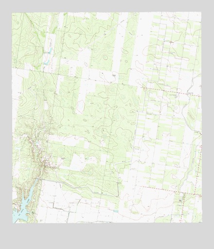
Citrus City, TX USGS Topographic Map
Click on map above to begin viewing in our Map Viewer.

This topographic map contains these locations and features:
Feature Name Type Latitude Longitude GNIS ID View Map
Abram North ColoniaPopulated PlaceN26.2873°W98.3864°2009995View Map
Acevedo Number 3 ColoniaPopulated PlaceN26.2892°W98.3759°2009960View Map
Basham Number 12 ColoniaPopulated PlaceN26.2692°W98.3822°2009905View Map
Basham Number 13 ColoniaPopulated PlaceN26.2734°W98.3814°2009906View Map
Basham Number 16 ColoniaPopulated PlaceN26.2723°W98.3822°2009909View Map
Celso ColoniaPopulated PlaceN26.2753°W98.3814°2010501View Map
Citrus CityPopulated PlaceN26.3265°W98.3853°1378124View Map
Citrus City Census Designated PlaceCensusN26.3281°W98.3923°2407625View Map
City of La JoyaCivilN26.2518°W98.4699°2411573View Map
City of PenitasCivilN26.2508°W98.4426°2411400View Map
Daniel Ozuna ColoniaPopulated PlaceN26.2773°W98.4434°2010464View Map
DoffingPopulated PlaceN26.2745°W98.3859°1852698View Map
Doffing Census Designated PlaceCensusN26.2788°W98.3856°2408677View Map
El Flaco Chiquito ColoniaPopulated PlaceN26.3253°W98.3884°2010384View Map
El Veleno RanchLocaleN26.3376°W98.4336°1335290View Map
Elodia R Chapa Elementary SchoolSchoolN26.2865°W98.3764°1986298View Map
Enrique Bazan ColoniaPopulated PlaceN26.2815°W98.3792°2010402View Map
Goodwin Heights Number 1 ColoniaPopulated PlaceN26.2592°W98.3864°2011195View Map
Henry B Gonzales Elementary SchoolSchoolN26.2622°W98.3866°1986297View Map
Hidalgo County Water District Number 16ReserveN26.3256°W98.3914°1384394View Map
Jimmy Carter High SchoolSchoolN26.2515°W98.4768°1986294View Map
Juarez - Lincoln High SchoolSchoolN26.2548°W98.4759°1986293View Map
Kountry Hill Estates ColoniaPopulated PlaceN26.2565°W98.3872°2011142View Map
La Joya CreekStreamN26.2767°W98.4839°1339335View Map
La Joya DamDamN26.2503°W98.4986°1861717View Map
La Joya LakeReservoirN26.2589°W98.4943°1339337View Map
La Joya Senior High SchoolSchoolN26.2532°W98.4727°1986295View Map
La Lomita MissionBuildingN26.3137°W98.3928°2014604View Map
La Morita WindmillLocaleN26.3515°W98.4761°1339358View Map
La Paloma Site ColoniaPopulated PlaceN26.2703°W98.3864°2011118View Map
Lorenzo de Zavala Middle SchoolSchoolN26.2509°W98.4661°1986296View Map
Mary K Acres ColoniaPopulated PlaceN26.2592°W98.3892°2011063View Map
Munoz Estates ColoniaPopulated PlaceN26.2665°W98.3814°2011048View Map
Orleander Estates ColoniaPopulated PlaceN26.2715°W98.4172°2010981View Map
Palmarina ColoniaPopulated PlaceN26.2565°W98.3914°2010996View Map
Puerta Blanca ColoniaPopulated PlaceN26.2823°W98.4403°2010965View Map
Ramona ColoniaPopulated PlaceN26.2742°W98.4384°2010937View Map
Reina ColoniaPopulated PlaceN26.2753°W98.4392°2010898View Map
Salida del Sol Estates ColoniaPopulated PlaceN26.3242°W98.4403°2010928View Map
Santa Rita RanchLocaleN26.2887°W98.4681°1346667View Map
Sullivan City DivisionCivilN26.3348°W98.4628°1939239View Map
Tabasco Oil and Gas FieldOilfieldN26.2559°W98.4536°1376366View Map
Western Estates Number 1 ColoniaPopulated PlaceN26.3234°W98.3953°2011478View Map

Note: Coordinates in the location and feature list above are referenced to NAD83 datum.


Copyright (C) 2008-2025 Ryan Niemi / Sunset Dynamics ... All Rights Reserved