TopoQuest Logo
Do you find TopoQuest useful?
Help keep TopoQuest running and adding new maps/features by donating!
Bitcoin:  19c7KJd3qBynnjoSw5npx9KScwjBe4ifkT
Litecoin:  LXs6TkuXGGXo1vDsWCkWVdjQX94eUKd6ui
Home View Maps Find Maps Find Places Resources & Links


Clanton Draw, New Mexico Topographic Map

USGS Map Title: Clanton Draw, NM
USGS Map MRC: 31108E8
DRG (GeoTIFF) Download: o31108e8.tif


Neighboring USGS Topographic Map Quads:


  Skull Canyon, NM  
31109F1
 

  Mount Baldy, NM  
31108F8
 

  Animas Peak NE, NM  
31108F7
 

  Skeleton Canyon, NM  
31109E1
 

  Clanton Draw, NM  
31108E8
 

  Animas Peak, NM  
31108E7
 

  Guadalupe Spring, NM  
31109D1
 

  Black Point, NM  
31108D8
 

  Fitzpatricks, NM  
31108D7


Map MRC Location:

N32°
W109°
N32°
W108°
H8 H7 H6 H5 H4 H3 H2 H1
G8 G7 G6 G5 G4 G3 G2 G1
F8 F7 F6 F5 F4 F3 F2 F1
E8 E7 E6 E5 E4 E3 E2 E1
D8 D7 D6 D5 D4 D3 D2 D1
C8 C7 C6 C5 C4 C3 C2 C1
B8 B7 B6 B5 B4 B3 B2 B1
A8 A7 A6 A5 A4 A3 A2 A1
N31°
W109°
N31°
W108°

Clanton Draw, NM USGS 1:24K Topographic Map Preview:
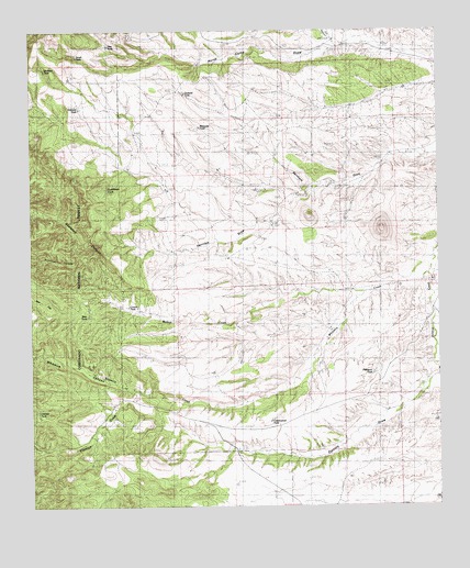
Clanton Draw, NM USGS Topographic Map
Click on map above to begin viewing in our Map Viewer.

This topographic map contains these locations and features:
Feature Name Type Latitude Longitude GNIS ID View Map
Bercham DrawValleyN31.5940°W108.8767°886233View Map
Bow TankReservoirN31.5502°W108.9832°2568061View Map
Clanton DrawValleyN31.5337°W108.8773°887634View Map
Clanton TankReservoirN31.5250°W108.9987°2568073View Map
Clanton TankReservoirN31.5330°W108.8751°2568075View Map
Cottonwood TankReservoirN31.5225°W108.9275°2568071View Map
Cowan TankReservoirN31.5524°W108.9681°2568063View Map
Cox CanyonValleyN31.6231°W108.9078°2568248View Map
Dutchman CanyonValleyN31.5779°W108.9867°898303View Map
Dutchman TankReservoirN31.5836°W108.9769°2568058View Map
Field RanchLocaleN31.5315°W108.9720°889013View Map
Geronimo CampgroundsLocaleN31.5158°W108.9928°2680677View Map
Gowan RanchLocaleN31.5545°W108.9703°889517View Map
Herridge DrawArroyoN31.5839°W108.9144°2568060View Map
Irishman TankReservoirN31.6047°W108.9855°2568054View Map
Last Chance DrawValleyN31.5612°W108.8776°895530View Map
Maddox TankReservoirN31.6150°W108.9960°2568053View Map
Mesquite TankReservoirN31.5997°W108.9486°2568056View Map
New TankReservoirN31.6214°W108.9764°2568051View Map
Orchard TankReservoirN31.6085°W108.9531°2568055View Map
Patterson TankReservoirN31.5350°W108.8958°2568072View Map
South TankReservoirN31.6183°W108.9858°2568050View Map
Upshaw RanchLocaleN31.5756°W108.9267°2568059View Map
Walnut CreekStreamN31.5657°W108.8781°896223View Map
Whitmire CanyonValleyN31.5568°W108.8989°896567View Map
Whitmire CreekStreamN31.5653°W108.8769°2568048View Map

Note: Coordinates in the location and feature list above are referenced to NAD83 datum.


Copyright (C) 2008-2025 Ryan Niemi / Sunset Dynamics ... All Rights Reserved