TopoQuest Logo
Do you find TopoQuest useful?
Help keep TopoQuest running and adding new maps/features by donating!
Bitcoin:  19c7KJd3qBynnjoSw5npx9KScwjBe4ifkT
Litecoin:  LXs6TkuXGGXo1vDsWCkWVdjQX94eUKd6ui
Home View Maps Find Maps Find Places Resources & Links


Clawson, Idaho Topographic Map

USGS Map Title: Clawson, ID
USGS Map MRC: 43111G1
DRG (GeoTIFF) Download: o43111g1.tif


Neighboring USGS Topographic Map Quads:


  Lamont, ID  
43111H2
 

  McRenolds Reservoir, ID  
43111H1
 

  Rammell Mountain, WY  
43110H8
 

  Tetonia, ID  
43111G2
 

  Clawson, ID  
43111G1
 

  Granite Basin, WY  
43110G8
 

  Bates, ID  
43111F2
 

  Driggs, ID  
43111F1
 

  Mount Bannon, WY  
43110F8


Map MRC Location:

N44°
W112°
N44°
W111°
H8 H7 H6 H5 H4 H3 H2 H1
G8 G7 G6 G5 G4 G3 G2 G1
F8 F7 F6 F5 F4 F3 F2 F1
E8 E7 E6 E5 E4 E3 E2 E1
D8 D7 D6 D5 D4 D3 D2 D1
C8 C7 C6 C5 C4 C3 C2 C1
B8 B7 B6 B5 B4 B3 B2 B1
A8 A7 A6 A5 A4 A3 A2 A1
N43°
W112°
N43°
W111°

Clawson, ID USGS 1:24K Topographic Map Preview:
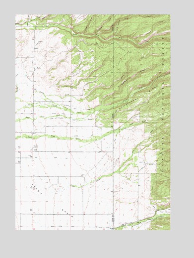
Clawson, ID USGS Topographic Map
Click on map above to begin viewing in our Map Viewer.

This topographic map contains these locations and features:
Feature Name Type Latitude Longitude GNIS ID View Map
AltaPopulated PlaceN43.7538°W111.0369°1597199View Map
Alta Census Designated PlaceCensusN43.7736°W111.0313°2407730View Map
Alta Elementary SchoolSchoolN43.7544°W111.0373°1795640View Map
Blind CreekStreamN43.8599°W111.0313°1605550View Map
Bustle CreekStreamN43.7891°W111.0238°1598538View Map
Center CanalCanalN43.8177°W111.0991°379125View Map
ClawsonPopulated PlaceN43.7980°W111.1108°399831View Map
DeCoster TrailTrailN43.8680°W111.0447°1587388View Map
Dry CanyonValleyN43.7569°W111.0110°1599324View Map
Dry CreekStreamN43.7703°W111.0956°380806View Map
Edison and Ricks CanalCanalN43.8146°W111.0841°381255View Map
Grand Teton CanalCanalN43.7519°W111.0694°382500View Map
Grand Teton CanalCanalN43.7521°W111.0419°1589026View Map
Grouse CreekStreamN43.8339°W111.1237°382713View Map
Haden CanalCanalN43.8510°W111.1116°382790View Map
Hog CanalCanalN43.7919°W111.1152°383236View Map
Jackson Hole Fire and EMS 5 AltaBuildingN43.7546°W111.0369°2673495View Map
Johns CreekStreamN43.8630°W111.0727°383965View Map
Kiln CreekStreamN43.7841°W111.0447°1600717View Map
Kilpack CanalCanalN43.8041°W111.0699°384217View Map
Little Dry CreekStreamN43.8083°W111.1108°384811View Map
North Badger CreekStreamN43.8706°W111.1142°387645View Map
North Leigh CanalCanalN43.8199°W111.0741°387825View Map
Pratt CanalCanalN43.7719°W111.0158°1593022View Map
Pratt CemeteryCemeteryN43.7619°W111.0129°2774435View Map
South Badger CreekStreamN43.8708°W111.1141°390873View Map
Steep CreekStreamN43.8624°W111.0584°391407View Map
Teton CanyonValleyN43.7588°W111.0108°1603579View Map
Wiggleton HollowValleyN43.8225°W111.0558°393412View Map
Yellow CreekStreamN43.8630°W111.0616°393743View Map

Note: Coordinates in the location and feature list above are referenced to NAD83 datum.


Copyright (C) 2008-2024 Ryan Niemi / Sunset Dynamics ... All Rights Reserved