TopoQuest Logo
Do you find TopoQuest useful?
Help keep TopoQuest running and adding new maps/features by donating!
Bitcoin:  19c7KJd3qBynnjoSw5npx9KScwjBe4ifkT
Litecoin:  LXs6TkuXGGXo1vDsWCkWVdjQX94eUKd6ui
Home View Maps Find Maps Find Places Resources & Links


Clear Creek, Indiana Topographic Map

USGS Map Title: Clear Creek, IN
USGS Map MRC: 39086A5
DRG (GeoTIFF) Download: o39086a5.tif


Neighboring USGS Topographic Map Quads:


  Whitehall, IN  
39086B6
 

  Bloomington, IN  
39086B5
 

  Unionville, IN  
39086B4
 

  Stanford, IN  
39086A6
 

  Clear Creek, IN  
39086A5
 

  Allens Creek, IN  
39086A4
 

  Owensburg, IN  
38086H6
 

  Oolitic, IN  
38086H5
 

  Bartlettsville, IN  
38086H4


Map MRC Location:

N40°
W87°
N40°
W86°
H8 H7 H6 H5 H4 H3 H2 H1
G8 G7 G6 G5 G4 G3 G2 G1
F8 F7 F6 F5 F4 F3 F2 F1
E8 E7 E6 E5 E4 E3 E2 E1
D8 D7 D6 D5 D4 D3 D2 D1
C8 C7 C6 C5 C4 C3 C2 C1
B8 B7 B6 B5 B4 B3 B2 B1
A8 A7 A6 A5 A4 A3 A2 A1
N39°
W87°
N39°
W86°

Clear Creek, IN USGS 1:24K Topographic Map Preview:
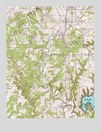
Clear Creek, IN USGS Topographic Map
Click on map above to begin viewing in our Map Viewer.

This topographic map contains these locations and features:
Feature Name Type Latitude Longitude GNIS ID View Map
Bloomington SpeedwayLocaleN39.1100°W86.5236°452286View Map
Bowen HollowValleyN39.0350°W86.5979°431390View Map
Cedar CliffsCliffN39.0373°W86.5631°432263View Map
Chambers CemeteryCemeteryN39.0234°W86.5325°432388View Map
Clear CreekPopulated PlaceN39.1092°W86.5400°449639View Map
Clover Hill CemeteryCemeteryN39.0159°W86.5472°432684View Map
Crum PointCliffN39.0387°W86.5983°433224View Map
Deelsville ChurchChurchN39.0631°W86.5417°433409View Map
Depot HillSummitN39.0117°W86.5264°433486View Map
Garden AcresPopulated PlaceN39.1245°W86.5781°434942View Map
HarrodsburgPopulated PlaceN39.0134°W86.5450°435809View Map
Harrodsburg Census Designated PlaceCensusN39.0180°W86.5532°2583454View Map
Indian Creek SchoolSchoolN39.0487°W86.6106°436758View Map
Indian Creek Volunteer FirefightersBuildingN39.0489°W86.6100°2626360View Map
Jackson CreekStreamN39.1003°W86.5397°436884View Map
Judah BranchStreamN39.0028°W86.5244°451110View Map
Kelly PointCliffN39.0164°W86.5086°437228View Map
KirksvillePopulated PlaceN39.0459°W86.6131°437361View Map
Little Clear CreekStreamN39.0131°W86.5306°438013View Map
May CreekStreamN39.0395°W86.5783°438758View Map
Mays GreenhouseBuildingN39.0978°W86.5406°2649871View Map
Monroe HospitalHospitalN39.1210°W86.5721°2660534View Map
Mount Salem CemeteryCemeteryN39.0787°W86.5403°439694View Map
Perry - Clear Creek Fire Department Station 11BuildingN39.1225°W86.5281°2626610View Map
Perry - Clear Creek Fire Department Station 21BuildingN39.0311°W86.5214°2625507View Map
SandersPopulated PlaceN39.0798°W86.5133°442994View Map
Sanders Elementary SchoolSchoolN39.0853°W86.5172°442997View Map
SmithvillePopulated PlaceN39.0712°W86.5069°452083View Map
Smithville-Sanders Census Designated PlaceCensusN39.0597°W86.5108°2583471View Map
South Side ChurchChurchN39.0595°W86.5067°443853View Map
South Union ChurchChurchN39.0859°W86.5914°443864View Map
Starlite Drive-InLocaleN39.0583°W86.5431°2634476View Map
Sugar CreekStreamN39.0223°W86.5036°451520View Map
Township of Clear CreekCivilN39.0367°W86.5141°453222View Map
Township of PerryCivilN39.1213°W86.5176°453723View Map
VictorPopulated PlaceN39.0609°W86.5808°445274View Map
Walkers ChapelChurchN39.0387°W86.6158°445382View Map

Note: Coordinates in the location and feature list above are referenced to NAD83 datum.


Copyright (C) 2008-2024 Ryan Niemi / Sunset Dynamics ... All Rights Reserved