TopoQuest Logo
Do you find TopoQuest useful?
Help keep TopoQuest running and adding new maps/features by donating!
Bitcoin:  19c7KJd3qBynnjoSw5npx9KScwjBe4ifkT
Litecoin:  LXs6TkuXGGXo1vDsWCkWVdjQX94eUKd6ui
Home View Maps Find Maps Find Places Resources & Links


Cleghorn, Iowa Topographic Map

USGS Map Title: Cleghorn, IA
USGS Map MRC: 42095G6
DRG (GeoTIFF) Download: o42095g6.tif


Neighboring USGS Topographic Map Quads:


  Granville East, IA  
42095H7
 

  Paullina, IA  
42095H6
 

  Sutherland West, IA  
42095H5
 

  Marcus, IA  
42095G7
 

  Cleghorn, IA  
42095G6
 

  Cherokee North, IA  
42095G5
 

  Fielding, IA  
42095F7
 

  Quimby, IA  
42095F6
 

  Cherokee South, IA  
42095F5


Map MRC Location:

N43°
W96°
N43°
W95°
H8 H7 H6 H5 H4 H3 H2 H1
G8 G7 G6 G5 G4 G3 G2 G1
F8 F7 F6 F5 F4 F3 F2 F1
E8 E7 E6 E5 E4 E3 E2 E1
D8 D7 D6 D5 D4 D3 D2 D1
C8 C7 C6 C5 C4 C3 C2 C1
B8 B7 B6 B5 B4 B3 B2 B1
A8 A7 A6 A5 A4 A3 A2 A1
N42°
W96°
N42°
W95°

Cleghorn, IA USGS 1:24K Topographic Map Preview:
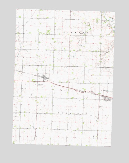
Cleghorn, IA USGS Topographic Map
Click on map above to begin viewing in our Map Viewer.

This topographic map contains these locations and features:
Feature Name Type Latitude Longitude GNIS ID View Map
Cedar FarmsLocaleN42.8094°W95.6628°2740305View Map
Christian ChurchChurchN42.8122°W95.7128°1907269View Map
City of CleghornCivilN42.8125°W95.7127°2393556View Map
City of MeridenCivilN42.7945°W95.6341°2395101View Map
CleghornLocaleN42.8111°W95.7133°1907270View Map
CleghornPopulated PlaceN42.8122°W95.7128°455470View Map
Cleghorn Fire DepartmentBuildingN42.8126°W95.7125°2371650View Map
Cleghorn Post OfficePost OfficeN42.8128°W95.7130°1907265View Map
Donaldson FarmsLocaleN42.8088°W95.7021°2740174View Map
First Cooperative Association ElevatorLocaleN42.8122°W95.7128°1907268View Map
First Farmers Cooperative ElevatorLocaleN42.7947°W95.6345°1907258View Map
French FarmsLocaleN42.8383°W95.6678°2740301View Map
Fuhrman FarmsLocaleN42.8367°W95.6801°2740175View Map
Gordon FarmsLocaleN42.8089°W95.6522°2740303View Map
Hurd FarmsLocaleN42.8013°W95.6601°2740176View Map
Jehovah's Witness Kingdom HallChurchN42.7947°W95.6345°1907257View Map
Johnson FarmLocaleN42.8614°W95.6993°2740177View Map
Leos PondReservoirN42.8429°W95.6671°458292View Map
Liberty CemeteryCemeteryN42.8369°W95.6364°458317View Map
Lundquist FarmsLocaleN42.7882°W95.7193°2740178View Map
M C Community LibraryBuildingN42.8122°W95.7128°1907267View Map
Macs PreserveParkN42.7797°W95.6997°1907146View Map
Marcus - Meriden - Cleghorn Elementary SchoolSchoolN42.8134°W95.7149°1907274View Map
Marcus Meriden Cleghorn SchoolSchoolN42.7933°W95.6347°1907259View Map
MeridenPopulated PlaceN42.7947°W95.6345°459003View Map
MeridenLocaleN42.7958°W95.6331°1907260View Map
Meriden CemeteryCemeteryN42.7869°W95.6428°459004View Map
Meriden Evangelical Free ChurchChurchN42.7947°W95.6345°1907256View Map
Meriden Fire DepartmentBuildingN42.7952°W95.6348°2577413View Map
Meriden Post OfficePost OfficeN42.7952°W95.6343°1907255View Map
Nelson FarmsLocaleN42.8167°W95.6431°2740302View Map
Presbyterian ChurchChurchN42.8122°W95.7128°1907266View Map
Rupp FarmLocaleN42.7510°W95.6767°2730050View Map
Shafer FarmsLocaleN42.8071°W95.7324°2740179View Map
Township of LibertyCivilN42.8665°W95.6816°468213View Map
Township of SheridanCivilN42.7792°W95.6818°468692View Map

Note: Coordinates in the location and feature list above are referenced to NAD83 datum.


Copyright (C) 2008-2025 Ryan Niemi / Sunset Dynamics ... All Rights Reserved