TopoQuest Logo
Do you find TopoQuest useful?
Help keep TopoQuest running and adding new maps/features by donating!
Bitcoin:  19c7KJd3qBynnjoSw5npx9KScwjBe4ifkT
Litecoin:  LXs6TkuXGGXo1vDsWCkWVdjQX94eUKd6ui
Home View Maps Find Maps Find Places Resources & Links


Clements, Minnesota Topographic Map

USGS Map Title: Clements, MN
USGS Map MRC: 44095D1
DRG (GeoTIFF) Download: o44095d1.tif


Neighboring USGS Topographic Map Quads:


  Delhi, MN  
44095E2
 

  Redwood Falls, MN  
44095E1
 

  Morton, MN  
44094E8
 

  Rowena, MN  
44095D2
 

  Clements, MN  
44095D1
 

  Morgan, MN  
44094D8
 

  Wanda, MN  
44095C2
 

  Clements SE, MN  
44095C1
 

  Boise Lake, MN  
44094C8


Map MRC Location:

N45°
W96°
N45°
W95°
H8 H7 H6 H5 H4 H3 H2 H1
G8 G7 G6 G5 G4 G3 G2 G1
F8 F7 F6 F5 F4 F3 F2 F1
E8 E7 E6 E5 E4 E3 E2 E1
D8 D7 D6 D5 D4 D3 D2 D1
C8 C7 C6 C5 C4 C3 C2 C1
B8 B7 B6 B5 B4 B3 B2 B1
A8 A7 A6 A5 A4 A3 A2 A1
N44°
W96°
N44°
W95°

Clements, MN USGS 1:24K Topographic Map Preview:
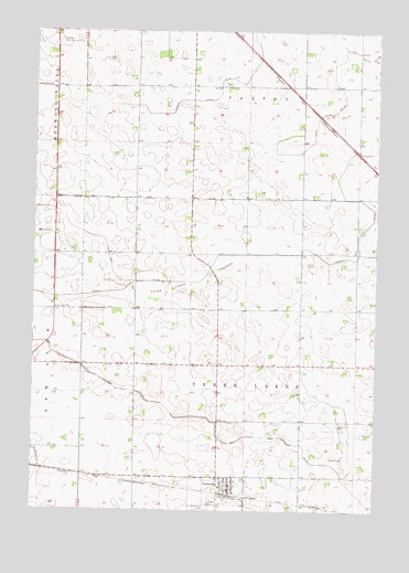
Clements, MN USGS Topographic Map
Click on map above to begin viewing in our Map Viewer.

This topographic map contains these locations and features:
Feature Name Type Latitude Longitude GNIS ID View Map
Bethlehem CemeteryCemeteryN44.3761°W95.0617°640048View Map
City of ClementsCivilN44.3801°W95.0548°2393557View Map
ClementsPopulated PlaceN44.3816°W95.0525°641326View Map
Clements (historical)LocaleN44.3789°W95.0528°2064518View Map
Clements City HallBuildingN44.3806°W95.0528°2064523View Map
Clements Post OfficePost OfficeN44.3797°W95.0531°2064520View Map
Clements Volunteer Fire Department and First RespondersBuildingN44.3812°W95.0527°2064519View Map
County Ditch Number One Hundred SixCanalN44.4844°W95.0130°641591View Map
County Ditch Number SixtyfourCanalN44.4347°W95.0836°642253View Map
County Ditch Number TwentyfourCanalN44.4063°W95.0906°641851View Map
County Ditch Number TwentytwoCanalN44.4830°W95.0581°641823View Map
Crestlawn Memorial GardenCemeteryN44.4972°W95.1169°642439View Map
Kingdom Hall of Jehovah's WitnessesChurchN44.3817°W95.0522°2064522View Map
Matthew Wilson PlotCemeteryN44.4086°W95.0830°2064563View Map
Robert Montgomery PlotCemeteryN44.4084°W95.0832°2064564View Map
Saint Joseph CemeteryCemeteryN44.3769°W95.0617°650752View Map
Saint Joseph's ChurchChurchN44.3811°W95.0558°2064521View Map
Schiller Turkey FarmLocaleN44.4817°W95.0181°2581941View Map
Three Lakes LakebedFlatN44.4352°W95.0664°653182View Map
Township of Three LakesCivilN44.4132°W95.0469°665786View Map

Note: Coordinates in the location and feature list above are referenced to NAD83 datum.


Copyright (C) 2008-2025 Ryan Niemi / Sunset Dynamics ... All Rights Reserved