TopoQuest Logo
Do you find TopoQuest useful?
Help keep TopoQuest running and adding new maps/features by donating!
Bitcoin:  19c7KJd3qBynnjoSw5npx9KScwjBe4ifkT
Litecoin:  LXs6TkuXGGXo1vDsWCkWVdjQX94eUKd6ui
Home View Maps Find Maps Find Places Resources & Links


Morton, Minnesota Topographic Map

USGS Map Title: Morton, MN
USGS Map MRC: 44094E8
DRG (GeoTIFF) Download: o44094e8.tif


Neighboring USGS Topographic Map Quads:


  Bechyn, MN  
44095F1
 

  Morton NW, MN  
44094F8
 

  Morton NE, MN  
44094F7
 

  Redwood Falls, MN  
44095E1
 

  Morton, MN  
44094E8
 

  Morton SE, MN  
44094E7
 

  Clements, MN  
44095D1
 

  Morgan, MN  
44094D8
 

  Morgan NE, MN  
44094D7


Map MRC Location:

N45°
W95°
N45°
W94°
H8 H7 H6 H5 H4 H3 H2 H1
G8 G7 G6 G5 G4 G3 G2 G1
F8 F7 F6 F5 F4 F3 F2 F1
E8 E7 E6 E5 E4 E3 E2 E1
D8 D7 D6 D5 D4 D3 D2 D1
C8 C7 C6 C5 C4 C3 C2 C1
B8 B7 B6 B5 B4 B3 B2 B1
A8 A7 A6 A5 A4 A3 A2 A1
N44°
W95°
N44°
W94°

Morton, MN USGS 1:24K Topographic Map Preview:
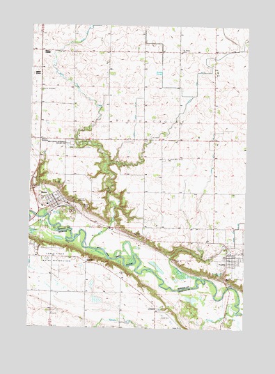
Morton, MN USGS Topographic Map
Click on map above to begin viewing in our Map Viewer.

This topographic map contains these locations and features:
Feature Name Type Latitude Longitude GNIS ID View Map
Andrew Robertson GraveCemeteryN44.5227°W94.9579°2064549View Map
Battle of Birch Coulee Historical MarkerParkN44.5767°W94.9778°2065563View Map
Birch Coulee Battlefield State Historic SiteParkN44.5758°W94.9750°640159View Map
Birch Coulee CreekStreamN44.5333°W94.9647°640158View Map
Cedar Mountain Elementary SchoolSchoolN44.5286°W94.8831°2065469View Map
City of FranklinCivilN44.5311°W94.8851°2394809View Map
City of MortonCivilN44.5533°W94.9849°2395414View Map
County Ditch Number One Hundred ElevenCanalN44.5616°W94.8961°1815475View Map
Dakotah Ridge Golf ClubLocaleN44.5500°W94.9833°2065450View Map
FranklinLocaleN44.5314°W94.8842°2065471View Map
FranklinPopulated PlaceN44.5283°W94.8805°643885View Map
Franklin Ambulance ServiceBuildingN44.5288°W94.8826°2721255View Map
Franklin Fire Department and Ambulance ServiceBuildingN44.5288°W94.8826°2065472View Map
Franklin Health Care CenterHospitalN44.5211°W94.8850°2065473View Map
Franklin Police DepartmentBuildingN44.5296°W94.8817°2065466View Map
Franklin Post OfficePost OfficeN44.5300°W94.8828°2065470View Map
Honorable JW Lynde Burial PlotCemeteryN44.5225°W94.9581°2064548View Map
Judicial Ditch Number TwelveCanalN44.6155°W94.8789°642844View Map
Knupple GraveCemeteryN44.5223°W94.9582°2064547View Map
Leo Hogan Wildlife Pond DamDamN44.5150°W94.9619°1777228View Map
Lower Sioux Community CemeteryCemeteryN44.5336°W94.9958°2064569View Map
Lower Sioux Indian CommunityCivilN44.5301°W94.9873°647264View Map
Lower Sioux Indian ReservationReserveN44.5333°W94.9836°654520View Map
Marguth Grave SiteCemeteryN44.5747°W94.9753°2065453View Map
Mdewakanton Repatriation Burial Site Historical MarkerParkN44.5336°W94.9958°2064570View Map
MortonLocaleN44.5500°W94.9833°2065449View Map
MortonPopulated PlaceN44.5513°W94.9844°648125View Map
Morton CemeteryCemeteryN44.5594°W94.9975°1815474View Map
Morton City Police DepartmentBuildingN44.5513°W94.9856°2065446View Map
Morton Fire DepartmentBuildingN44.5513°W94.9856°2666561View Map
Morton Pioneer Monuments Wayside ParkParkN44.5981°W94.9947°2065568View Map
Morton Post OfficePost OfficeN44.5508°W94.9839°2065445View Map
Morton Redwood Ferry Wayside ParkParkN44.5383°W94.9392°2065567View Map
Morton Wayside ParkParkN44.5522°W94.9722°2065565View Map
Patten Pioneer CemeteryCemeteryN44.5500°W94.9417°2065451View Map
Peavery Grave SiteCemeteryN44.5764°W94.9875°2065452View Map
Post-Newton CemeteryCemeteryN44.5305°W94.9833°2064546View Map
Redwood Ferry Historical MarkerParkN44.5383°W94.9392°2065566View Map
Renville County Historical MuseumBuildingN44.5544°W94.9839°2065444View Map
Sacred Heart Catholic ChurchChurchN44.5297°W94.8781°2065467View Map
Saint Cornelia's ChurchChurchN44.5272°W94.9667°2064565View Map
Saint Cornelia's Church Historical MarkerParkN44.5272°W94.9667°2064566View Map
Saint John CemeteryCemeteryN44.5597°W94.9817°1815473View Map
Saint John's Catholic ChurchChurchN44.5514°W94.9842°2065447View Map
Saint Luke's Lutheran ChurchChurchN44.5297°W94.8847°2065468View Map
Saint Patrick - Birch Cooley CemeteryCemeteryN44.5700°W94.9228°640157View Map
Saint Patrick ChurchChurchN44.6152°W94.9130°650941View Map
School Number 13LocaleN44.6150°W94.9114°651376View Map
School Number 135LocaleN44.6066°W94.9953°651383View Map
School Number 20LocaleN44.5780°W94.9033°651467View Map
Sioux Indian State MonumentParkN44.5522°W94.9722°2065564View Map
Sulphur LakeLakeN44.5405°W94.9998°652788View Map
Township of Birch CooleyCivilN44.5775°W94.9287°663594View Map
United States Bureau of Indian Affairs - Lower Sioux Indian Tribal Law Enforcement ServicesBuildingN44.5326°W94.9958°2758642View Map
Wabasha CreekStreamN44.5083°W94.8794°653696View Map
Whipple MissionChurchN44.5333°W94.9958°654063View Map
Woelfel SloughGutN44.6061°W94.9289°654299View Map
Zion Lutheran ChurchChurchN44.5542°W94.9889°2065448View Map

Note: Coordinates in the location and feature list above are referenced to NAD83 datum.


Copyright (C) 2008-2024 Ryan Niemi / Sunset Dynamics ... All Rights Reserved