TopoQuest Logo
Do you find TopoQuest useful?
Help keep TopoQuest running and adding new maps/features by donating!
Bitcoin:  19c7KJd3qBynnjoSw5npx9KScwjBe4ifkT
Litecoin:  LXs6TkuXGGXo1vDsWCkWVdjQX94eUKd6ui
Home View Maps Find Maps Find Places Resources & Links


Clermont, Georgia Topographic Map

USGS Map Title: Clermont, GA
USGS Map MRC: 34083D7
DRG (GeoTIFF) Download: o34083d7.tif


Neighboring USGS Topographic Map Quads:


  Dahlonega, GA  
34083E8
 

  Cleveland, GA  
34083E7
 

  Leaf, GA  
34083E6
 

  Murrayville, GA  
34083D8
 

  Clermont, GA  
34083D7
 

  Lula, GA  
34083D6
 

  Chestatee, GA  
34083C8
 

  Gainesville, GA  
34083C7
 

  Gillsville, GA  
34083C6


Map MRC Location:

N35°
W84°
N35°
W83°
H8 H7 H6 H5 H4 H3 H2 H1
G8 G7 G6 G5 G4 G3 G2 G1
F8 F7 F6 F5 F4 F3 F2 F1
E8 E7 E6 E5 E4 E3 E2 E1
D8 D7 D6 D5 D4 D3 D2 D1
C8 C7 C6 C5 C4 C3 C2 C1
B8 B7 B6 B5 B4 B3 B2 B1
A8 A7 A6 A5 A4 A3 A2 A1
N34°
W84°
N34°
W83°

Clermont, GA USGS 1:24K Topographic Map Preview:
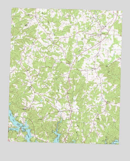
Clermont, GA USGS Topographic Map
Click on map above to begin viewing in our Map Viewer.

This topographic map contains these locations and features:
Feature Name Type Latitude Longitude GNIS ID View Map
Beaver PondPopulated PlaceN34.3912°W83.8032°1686699View Map
Bethel ChurchChurchN34.4668°W83.8491°311204View Map
BrooktonPopulated PlaceN34.4451°W83.7793°331248View Map
BrookwoodPopulated PlaceN34.3834°W83.8743°1686704View Map
Buckhorn MountainSummitN34.4057°W83.8541°311985View Map
Chattahoochee Christian SchoolSchoolN34.4851°W83.7682°1686709View Map
Cherokee Gun Club RangeLocaleN34.4076°W83.8555°1686710View Map
Christian ChurchChurchN34.4343°W83.8085°1686715View Map
Christian Hall ChurchChurchN34.4659°W83.7818°1686716View Map
Clarks Bridge PlacePopulated PlaceN34.3804°W83.7827°1686717View Map
ClermontPopulated PlaceN34.4779°W83.7735°331416View Map
Clermont DivisionCivilN34.4417°W83.7838°1936183View Map
Clermont Residential Historic DistrictParkN34.4768°W83.7752°1686719View Map
Cross Road ChurchChurchN34.4490°W83.8080°355383View Map
Destitute AcresPopulated PlaceN34.3757°W83.8466°1686724View Map
DevanePopulated PlaceN34.4007°W83.8691°1686725View Map
Dewberry CemeteryCemeteryN34.4204°W83.8085°1686726View Map
Dewberry CemeteryCemeteryN34.4131°W83.7657°1686727View Map
Dewberry Church Number 1ChurchN34.4140°W83.7649°355482View Map
Dewberry Church Number 2ChurchN34.4207°W83.8093°355483View Map
Eubank CreekStreamN34.4862°W83.7830°313980View Map
Fly-N-S Ranch AirportAirportN34.4510°W83.7887°2625389View Map
Full Gospel TabernacleChurchN34.3982°W83.7760°314450View Map
Glade ShoalsBarN34.4476°W83.7641°314633View Map
Gospel Assembly ChurchChurchN34.3812°W83.8621°1686735View Map
Hall County Fire Services Station 15BuildingN34.3902°W83.7757°2605004View Map
Hall County Fire Services Station 2BuildingN34.4459°W83.8042°2604699View Map
Hall County Sheriff's DepartmentBuildingN34.4774°W83.7744°2733822View Map
HargrovePopulated PlaceN34.3859°W83.8143°1686737View Map
Harkins Mill (historical)LocaleN34.4745°W83.8738°1688001View Map
Head Mill CreekStreamN34.4862°W83.7830°315269View Map
Heather HeightsPopulated PlaceN34.3929°W83.8224°1686738View Map
Hidden AcresPopulated PlaceN34.3757°W83.7707°1686739View Map
Lake HavenPopulated PlaceN34.3901°W83.8163°1686751View Map
Lake WatchPopulated PlaceN34.3787°W83.8121°1686754View Map
Land (historical)Populated PlaceN34.4432°W83.8068°1686982View Map
Lawson HighlandsPopulated PlaceN34.3915°W83.8310°1686758View Map
Martins LakeReservoirN34.4145°W83.8385°336669View Map
Martins Lake DamDamN34.4134°W83.8382°336668View Map
McCraryPopulated PlaceN34.4043°W83.8707°1686769View Map
Mount Vernon CemeteryCemeteryN34.4419°W83.8561°1686773View Map
Mount Vernon ChurchChurchN34.4415°W83.8557°318912View Map
Mount Vernon Elementary SchoolSchoolN34.4207°W83.8398°2546092View Map
Mount Vernon School (historical)SchoolN34.4273°W83.8507°1686774View Map
Nopone Lookout TowerTowerN34.3965°W83.8368°344306View Map
North Hall High SchoolSchoolN34.4265°W83.8507°2346430View Map
North Hall Middle SchoolSchoolN34.4239°W83.8517°2346431View Map
North Hall SchoolSchoolN34.4270°W83.8513°319652View Map
Oak HarborPopulated PlaceN34.3834°W83.8663°1686784View Map
River RunPopulated PlaceN34.4270°W83.8052°1686795View Map
Squirrel CreekStreamN34.3879°W83.8627°323490View Map
Squirrel CreekPopulated PlaceN34.3801°W83.8727°1686809View Map
Straightway ChurchChurchN34.4209°W83.7896°1686810View Map
Town of ClermontCivilN34.4781°W83.7730°2406277View Map
Trinity CemeteryCemeteryN34.4576°W83.7774°1686814View Map
Trinity ChurchChurchN34.4573°W83.7768°324318View Map
Wahoo ChurchChurchN34.4937°W83.8544°324743View Map
Wahoo Creek Access PointCapeN34.3873°W83.8599°324746View Map
Wahoo Creek BridgeBridgeN34.3895°W83.8593°324747View Map
Wahoo School (historical)SchoolN34.4932°W83.8544°1688003View Map
Walden WoodsPopulated PlaceN34.4265°W83.8132°1686822View Map
Walka Mountain CemeteryCemeteryN34.4937°W83.8118°1686823View Map
Walka Mountain ChurchChurchN34.4937°W83.8113°324761View Map
Wauka Mountain Elementary SchoolSchoolN34.4456°W83.8032°1686824View Map
WhelchelPopulated PlaceN34.3945°W83.8638°1686828View Map
WhitmirePopulated PlaceN34.4154°W83.8052°1686830View Map

Note: Coordinates in the location and feature list above are referenced to NAD83 datum.


Copyright (C) 2008-2025 Ryan Niemi / Sunset Dynamics ... All Rights Reserved