TopoQuest Logo
Do you find TopoQuest useful?
Help keep TopoQuest running and adding new maps/features by donating!
Bitcoin:  19c7KJd3qBynnjoSw5npx9KScwjBe4ifkT
Litecoin:  LXs6TkuXGGXo1vDsWCkWVdjQX94eUKd6ui
Home View Maps Find Maps Find Places Resources & Links


Murrayville, Georgia Topographic Map

USGS Map Title: Murrayville, GA
USGS Map MRC: 34083D8
DRG (GeoTIFF) Download: o34083d8.tif


Neighboring USGS Topographic Map Quads:


  Campbell Mountain, GA  
34084E1
 

  Dahlonega, GA  
34083E8
 

  Cleveland, GA  
34083E7
 

  Dawsonville, GA  
34084D1
 

  Murrayville, GA  
34083D8
 

  Clermont, GA  
34083D7
 

  Coal Mountain, GA  
34084C1
 

  Chestatee, GA  
34083C8
 

  Gainesville, GA  
34083C7


Map MRC Location:

N35°
W84°
N35°
W83°
H8 H7 H6 H5 H4 H3 H2 H1
G8 G7 G6 G5 G4 G3 G2 G1
F8 F7 F6 F5 F4 F3 F2 F1
E8 E7 E6 E5 E4 E3 E2 E1
D8 D7 D6 D5 D4 D3 D2 D1
C8 C7 C6 C5 C4 C3 C2 C1
B8 B7 B6 B5 B4 B3 B2 B1
A8 A7 A6 A5 A4 A3 A2 A1
N34°
W84°
N34°
W83°

Murrayville, GA USGS 1:24K Topographic Map Preview:
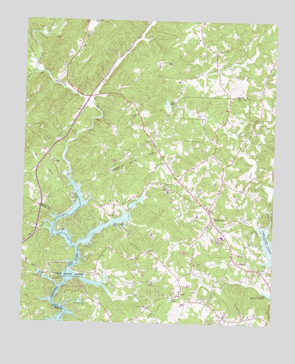
Murrayville, GA USGS Topographic Map
Click on map above to begin viewing in our Map Viewer.

This topographic map contains these locations and features:
Feature Name Type Latitude Longitude GNIS ID View Map
Albert (historical)Populated PlaceN34.4615°W83.9432°357146View Map
Bark Camp PlacePopulated PlaceN34.3795°W83.8880°1686696View Map
Bells BranchStreamN34.4776°W83.9971°311055View Map
Belvedere AcresPopulated PlaceN34.3812°W83.8902°1686701View Map
Big OakPopulated PlaceN34.3857°W83.9082°1686702View Map
Brierpatch Bridge (historical)BridgeN34.4812°W83.9946°357155View Map
BroadnaxPopulated PlaceN34.4098°W83.9630°1686703View Map
Bull CreekStreamN34.4415°W83.8849°312016View Map
Calhoun Dam (historical)DamN34.4968°W83.9846°357156View Map
Calhoun Gold MineMineN34.4920°W83.9821°312158View Map
Calvary ChurchChurchN34.3968°W83.9141°1686705View Map
Cane BranchStreamN34.4368°W83.9782°312282View Map
Cane CreekStreamN34.4943°W83.9927°354977View Map
Cool Springs CemeteryCemeteryN34.3820°W83.9374°1686721View Map
Cool Springs ChurchChurchN34.3815°W83.9369°355288View Map
Cool Springs ForestPopulated PlaceN34.3884°W83.9316°1686722View Map
Dahlonega QuarryMineN34.4814°W83.9439°2560324View Map
ElrodPopulated PlaceN34.4087°W83.8855°1686729View Map
Enon ChurchChurchN34.4884°W83.9730°357172View Map
Fairview School (historical)SchoolN34.4412°W83.9846°357175View Map
Gin BranchStreamN34.4151°W83.8827°314610View Map
Grant Ford (historical)CrossingN34.3876°W83.9827°1686736View Map
Halfway (historical)Populated PlaceN34.4793°W83.9099°357187View Map
Hall County Fire Station 11BuildingN34.4141°W83.9078°2604969View Map
Hall County Fire Station 3BuildingN34.3768°W83.8973°2604701View Map
Hickory Grove ChurchChurchN34.4882°W83.9038°315364View Map
Hopewell ChurchChurchN34.4034°W83.8885°315664View Map
Howser Mill (historical)LocaleN34.4162°W83.8774°1686745View Map
Indian HillsPopulated PlaceN34.3951°W83.8871°1686746View Map
Lake ShorePopulated PlaceN34.4159°W83.9707°1686753View Map
Lanier Elementary SchoolSchoolN34.4006°W83.8900°316647View Map
Leisure LakePopulated PlaceN34.4145°W83.9421°1686759View Map
Lighthouse ChurchChurchN34.4023°W83.9477°1686760View Map
Little Yellow CreekStreamN34.4245°W83.9405°317245View Map
Long BranchStreamN34.4657°W83.9666°328623View Map
Lumpkin Company ParkParkN34.4270°W83.9749°317485View Map
Maranantha ChurchChurchN34.4657°W83.9460°357200View Map
MarlowPopulated PlaceN34.4154°W83.9055°1686766View Map
Mount Olive ChurchChurchN34.4812°W83.9010°357203View Map
Mountain ViewPopulated PlaceN34.4159°W83.9794°1686776View Map
MurrayvillePopulated PlaceN34.4187°W83.9057°332457View Map
Murrayville ChurchChurchN34.4243°W83.9099°1686779View Map
Murrayville ChurchChurchN34.4159°W83.8993°1686780View Map
Murrayville DivisionCivilN34.3809°W83.9232°1936425View Map
Murrayville Holiness ChurchChurchN34.4126°W83.9102°1686781View Map
New Bridge (historical)Populated PlaceN34.4312°W83.9721°1688002View Map
North ForestPopulated PlaceN34.3976°W83.9369°1686782View Map
Northlake ChurchChurchN34.4009°W83.8943°1686783View Map
Pine LakeReservoirN34.3846°W83.9256°320620View Map
Ponys LakeReservoirN34.4654°W83.9286°321001View Map
Ponys Lake DamDamN34.4643°W83.9288°336662View Map
Ponys Lake DamDamN34.4651°W83.9282°339949View Map
PricePopulated PlaceN34.3865°W83.9210°332759View Map
Price School (historical)SchoolN34.3893°W83.9196°1686792View Map
Ralston BranchStreamN34.4834°W83.9944°321295View Map
Rock Hill ChurchChurchN34.3776°W83.8985°321734View Map
Rock Hill Congregational CemeteryCemeteryN34.3774°W83.8989°1686796View Map
Saint Pauls ChurchChurchN34.4504°W83.9360°322287View Map
Sardis HeightsPopulated PlaceN34.3762°W83.9041°1686798View Map
Soules ChapelChurchN34.4409°W83.9849°323226View Map
Split Oak CreekStreamN34.4182°W83.9302°1686806View Map
TimberidgePopulated PlaceN34.3901°W83.9707°1686813View Map
Toto CreekStreamN34.3968°W83.9921°324232View Map
Toto Creek Access PointCapeN34.3932°W83.9849°324233View Map
Toto Creek BridgeBridgeN34.3945°W83.9896°324234View Map
Town CreekStreamN34.4779°W83.9946°324257View Map
Turkey HillSummitN34.4879°W83.9855°357228View Map
Turkey Hill MineMineN34.4882°W83.9855°357218View Map
Wahoo ForestPopulated PlaceN34.4032°W83.8818°1686820View Map
Wahoo ValleyPopulated PlaceN34.3973°W83.8763°1686821View Map
WelchellPopulated PlaceN34.4034°W83.9663°1686826View Map
Wilkie BridgeBridgeN34.3982°W83.9757°325306View Map
Wilkie Ford (historical)CrossingN34.4029°W83.9719°1687109View Map
Woodmen of the World Youth CampLocaleN34.3843°W83.9702°325544View Map
Woodmen Youth Camp DamDamN34.3834°W83.9732°338752View Map
Woodmen Youth Camp LakeReservoirN34.3834°W83.9732°338753View Map
Yellow CreekStreamN34.4273°W83.9399°325611View Map
Yellow Creek CemeteryCemeteryN34.4315°W83.9280°325615View Map
Yellow Creek ChurchChurchN34.4298°W83.9285°325617View Map

Note: Coordinates in the location and feature list above are referenced to NAD83 datum.


Copyright (C) 2008-2024 Ryan Niemi / Sunset Dynamics ... All Rights Reserved