TopoQuest Logo
Do you find TopoQuest useful?
Help keep TopoQuest running and adding new maps/features by donating!
Bitcoin:  19c7KJd3qBynnjoSw5npx9KScwjBe4ifkT
Litecoin:  LXs6TkuXGGXo1vDsWCkWVdjQX94eUKd6ui
Home View Maps Find Maps Find Places Resources & Links


Cleveland, Oklahoma Topographic Map

USGS Map Title: Cleveland, OK
USGS Map MRC: 36096C4
DRG (GeoTIFF) Download: o36096c4.tif


Neighboring USGS Topographic Map Quads:


  Bug Creek, OK  
36096D5
 

  Hominy, OK  
36096D4
 

  Hominy NE, OK  
36096D3
 

  Blackburn, OK  
36096C5
 

  Cleveland, OK  
36096C4
 

  New Prue, OK  
36096C3
 

  Jennings, OK  
36096B5
 

  Terlton, OK  
36096B4
 

  Keystone Dam, OK  
36096B3


Map MRC Location:

N37°
W97°
N37°
W96°
H8 H7 H6 H5 H4 H3 H2 H1
G8 G7 G6 G5 G4 G3 G2 G1
F8 F7 F6 F5 F4 F3 F2 F1
E8 E7 E6 E5 E4 E3 E2 E1
D8 D7 D6 D5 D4 D3 D2 D1
C8 C7 C6 C5 C4 C3 C2 C1
B8 B7 B6 B5 B4 B3 B2 B1
A8 A7 A6 A5 A4 A3 A2 A1
N36°
W97°
N36°
W96°

Cleveland, OK USGS 1:24K Topographic Map Preview:
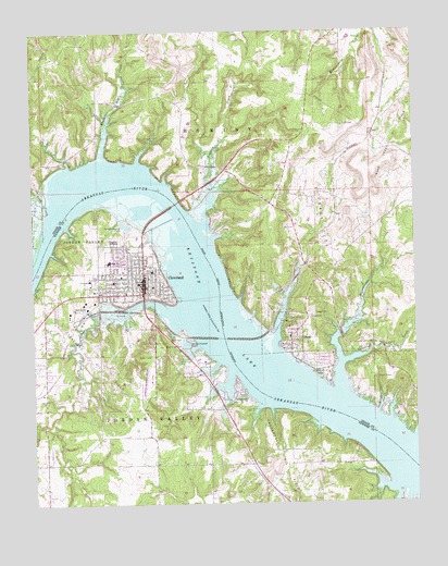
Cleveland, OK USGS Topographic Map
Click on map above to begin viewing in our Map Viewer.

This topographic map contains these locations and features:
Feature Name Type Latitude Longitude GNIS ID View Map
Bear Creek CemeteryCemeteryN36.2923°W96.4531°1089913View Map
Black Dog CreekStreamN36.3412°W96.4761°1090196View Map
Boar Creek Oil FieldOilfieldN36.3423°W96.3817°1090314View Map
Boston Oil FieldOilfieldN36.3253°W96.4984°1090409View Map
Cedar CreekStreamN36.3028°W96.4609°1091098View Map
City of ClevelandCivilN36.3109°W96.4713°2409481View Map
ClevelandPopulated PlaceN36.3101°W96.4642°1091455View Map
Cleveland Area HospitalHospitalN36.3093°W96.4818°2695688View Map
Cleveland Fire DepartmentBuildingN36.3093°W96.4644°2656956View Map
Cleveland High SchoolSchoolN36.3143°W96.4752°1803923View Map
Cleveland Intermediate Elementary SchoolSchoolN36.3158°W96.4777°1803924View Map
Cleveland Middle SchoolSchoolN36.3138°W96.4773°1803922View Map
Cleveland Municipal AirportAirportN36.2825°W96.4620°1102414View Map
Cleveland Oil FieldOilfieldN36.2878°W96.4822°1091457View Map
Cleveland Police DepartmentBuildingN36.3092°W96.4648°2757673View Map
Cleveland Primary Elementary SchoolSchoolN36.3119°W96.4773°1803925View Map
Dixie CemeteryCemeteryN36.2931°W96.4531°1092101View Map
Feyodi Creek State ParkParkN36.2781°W96.4331°1763740View Map
First Assembly of GodChurchN36.3137°W96.4722°1782727View Map
First Baptist ChurchChurchN36.3081°W96.4622°1782728View Map
First Christian ChurchChurchN36.3090°W96.4653°1782729View Map
First Presbyterian ChurchChurchN36.3092°W96.4617°1782730View Map
Grace Baptist ChurchChurchN36.3101°W96.4800°1782731View Map
Kingdom Hall-Jehovahs WitnessChurchN36.3112°W96.4603°1782732View Map
Lauderdale Oil FieldOilfieldN36.2620°W96.4211°1094524View Map
Lauderdale Oil FieldOilfieldN36.3048°W96.4272°1094525View Map
Mechetsemoi CreekStreamN36.2798°W96.4006°1095283View Map
Mercy Regional Ambulance Service ClevelandBuildingN36.3093°W96.4644°2695846View Map
Methodist ChurchChurchN36.3090°W96.4631°1782733View Map
Mill CreekStreamN36.2667°W96.3750°1095397View Map
Oknoname 113100 DamDamN36.3067°W96.4203°1753838View Map
Oknoname 113100 ReservoirReservoirN36.3067°W96.4203°1753839View Map
Oknoname 113101 DamDamN36.3684°W96.4320°1753840View Map
Oknoname 113101 ReservoirReservoirN36.3684°W96.4320°1753841View Map
OsagePopulated PlaceN36.2928°W96.4159°1096307View Map
Osage CemeteryCemeteryN36.3001°W96.4089°1096309View Map
Osage City Oil FieldOilfieldN36.3115°W96.4036°1096311View Map
Osage Point ParkParkN36.2834°W96.4067°1096325View Map
Osage Volunteer Fire DepartmentBuildingN36.2941°W96.4151°2657048View Map
Sand CreekStreamN36.3267°W96.4959°1097753View Map
Scanlon CreekStreamN36.3228°W96.4450°1097863View Map
Town of OsageCivilN36.2949°W96.4180°2413093View Map
Township of Jordan ValleyCivilN36.2723°W96.4586°1824843View Map
Vandruff CreekStreamN36.2873°W96.3986°1099223View Map
Woodland CemeteryCemeteryN36.3198°W96.4736°1099985View Map

Note: Coordinates in the location and feature list above are referenced to NAD83 datum.


Copyright (C) 2008-2024 Ryan Niemi / Sunset Dynamics ... All Rights Reserved