TopoQuest Logo
Do you find TopoQuest useful?
Help keep TopoQuest running and adding new maps/features by donating!
Bitcoin:  19c7KJd3qBynnjoSw5npx9KScwjBe4ifkT
Litecoin:  LXs6TkuXGGXo1vDsWCkWVdjQX94eUKd6ui
Home View Maps Find Maps Find Places Resources & Links


Cliffdell, Washington Topographic Map

USGS Map Title: Cliffdell, WA
USGS Map MRC: 46121H1
DRG (GeoTIFF) Download: o46121h1.tif


Neighboring USGS Topographic Map Quads:


  Mount Clifty, WA  
47121A2
 

  Quartz Mountain, WA  
47121A1
 

  Frost Mountain, WA  
47120A8
 

  Old Scab Mountain, WA  
46121H2
 

  Cliffdell, WA  
46121H1
 

  Manastash Lake, WA  
46120H8
 

  Timberwolf Mountain, WA  
46121G2
 

  Meeks Table, WA  
46121G1
 

  Nile, WA  
46120G8


Map MRC Location:

N47°
W122°
N47°
W121°
H8 H7 H6 H5 H4 H3 H2 H1
G8 G7 G6 G5 G4 G3 G2 G1
F8 F7 F6 F5 F4 F3 F2 F1
E8 E7 E6 E5 E4 E3 E2 E1
D8 D7 D6 D5 D4 D3 D2 D1
C8 C7 C6 C5 C4 C3 C2 C1
B8 B7 B6 B5 B4 B3 B2 B1
A8 A7 A6 A5 A4 A3 A2 A1
N46°
W122°
N46°
W121°

Cliffdell, WA USGS 1:24K Topographic Map Preview:
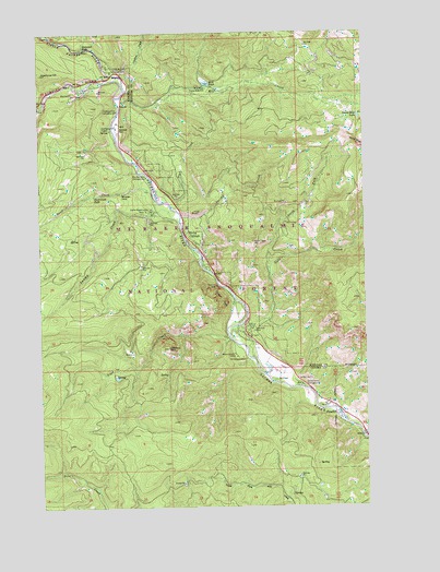
Cliffdell, WA USGS Topographic Map
Click on map above to begin viewing in our Map Viewer.

This topographic map contains these locations and features:
Feature Name Type Latitude Longitude GNIS ID View Map
Boulder Cave CampgroundLocaleN46.9618°W121.0840°1516819View Map
Bumping RiverStreamN46.9885°W121.0940°1517093View Map
Camp RoganundaLocaleN46.9535°W121.0823°1517307View Map
Catchup CreekStreamN46.9885°W121.0940°1517492View Map
Cedar SpringSpringN46.9743°W121.0988°1517579View Map
Chinook Pass Work CenterLocaleN46.9021°W121.0167°1529872View Map
Christian CampLocaleN46.9140°W121.0470°1517753View Map
CliffdellPopulated PlaceN46.9462°W121.0690°1517860View Map
Cliffdell Census Designated PlaceCensusN46.9214°W121.0421°2584961View Map
Cottonwood CampgroundLocaleN46.9071°W121.0259°1518138View Map
Deadhorse HillSummitN46.9890°W121.1248°1518542View Map
Devil CreekStreamN46.9571°W121.0820°1518690View Map
Devil Creek FallsFallsN46.9569°W121.1050°1518691View Map
Devils Slide LakeLakeN46.9776°W121.0031°1518723View Map
Edgar RockCliffN46.9293°W121.0565°1519186View Map
Edgar Rock Lookout TowerTowerN46.9296°W121.0598°1534092View Map
Gold CreekStreamN46.9226°W121.0495°1520082View Map
Halfway Flat CampgroundLocaleN46.9793°W121.0951°1520457View Map
Halfway Flat CampgroundLocaleN46.9837°W121.0948°1529807View Map
Haystack RockPillarN46.9168°W121.0765°1520634View Map
Horsetail FallsFallsN46.9964°W121.1085°1520973View Map
Little Naches CampgroundLocaleN46.9896°W121.0976°1522275View Map
Little Naches RiverStreamN46.9896°W121.0973°1522276View Map
Little Naches Summer HomesLocaleN46.9915°W121.0995°1534126View Map
Lost CreekStreamN46.9196°W121.0534°1522462View Map
Milk CreekStreamN46.9832°W121.0934°1523134View Map
Milk PondLakeN46.9866°W121.0614°1523141View Map
Milk Pond DamDamN46.9860°W121.0595°1532448View Map
Milk Pond Picnic GroundsLocaleN46.9851°W121.0604°1523142View Map
Mountain Air CampLocaleN46.9146°W121.0504°1523436View Map
Naches Ranger StationLocaleN46.9079°W121.0248°1534093View Map
North Fork Gold CreekStreamN46.9362°W121.0376°1523779View Map
Peterson CemeteryCemeteryN46.9215°W121.0429°1524357View Map
Pine CreekStreamN46.9537°W121.0729°1524437View Map
PinecliffPopulated PlaceN46.8993°W121.0131°1524454View Map
Sawmill FlatFlatN46.9748°W121.0954°1525457View Map
Sawmill Flat CampgroundLocaleN46.9748°W121.0956°1534094View Map
Spring CreekStreamN46.9512°W121.0706°1526408View Map
Swamp CreekStreamN46.9498°W121.0715°1526824View Map
Yakima County Fire District 14 Nile - Cliffdell Fire - Rescue Department Station 10 Gold CreekBuildingN46.9148°W121.0380°2643937View Map
Yakima County Fire District 14 Nile - Cliffdell Fire - Rescue Department Station 12BuildingN46.9403°W121.0631°2643938View Map

Note: Coordinates in the location and feature list above are referenced to NAD83 datum.


Copyright (C) 2008-2024 Ryan Niemi / Sunset Dynamics ... All Rights Reserved