TopoQuest Logo
Do you find TopoQuest useful?
Help keep TopoQuest running and adding new maps/features by donating!
Bitcoin:  19c7KJd3qBynnjoSw5npx9KScwjBe4ifkT
Litecoin:  LXs6TkuXGGXo1vDsWCkWVdjQX94eUKd6ui
Home View Maps Find Maps Find Places Resources & Links


Clubhouse Lake, Minnesota Topographic Map

USGS Map Title: Clubhouse Lake, MN
USGS Map MRC: 47093E5
DRG (GeoTIFF) Download: o47093e5.tif


Neighboring USGS Topographic Map Quads:


  Bigfork, MN  
47093F6
 

  Coon Lake, MN  
47093F5


  Clubhouse Lake, MN  
47093E5
 

  Balsam Lake, MN  
47093E4


Map MRC Location:

N48°
W94°
N48°
W93°
H8 H7 H6 H5 H4 H3 H2 H1
G8 G7 G6 G5 G4 G3 G2 G1
F8 F7 F6 F5 F4 F3 F2 F1
E8 E7 E6 E5 E4 E3 E2 E1
D8 D7 D6 D5 D4 D3 D2 D1
C8 C7 C6 C5 C4 C3 C2 C1
B8 B7 B6 B5 B4 B3 B2 B1
A8 A7 A6 A5 A4 A3 A2 A1
N47°
W94°
N47°
W93°

Clubhouse Lake, MN USGS 1:24K Topographic Map Preview:
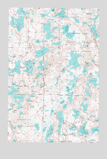
Clubhouse Lake, MN USGS Topographic Map
Click on map above to begin viewing in our Map Viewer.

This topographic map contains these locations and features:
Feature Name Type Latitude Longitude GNIS ID View Map
Allen LakeLakeN47.5624°W93.5013°655108View Map
Baldy LakeLakeN47.5392°W93.5965°655200View Map
Big Dick LakeLakeN47.6105°W93.6093°655361View Map
Big Island LakeLakeN47.5703°W93.5959°655367View Map
Big Jack LakeLakeN47.5268°W93.6072°655368View Map
Big Ole LakeLakeN47.5689°W93.6142°655371View Map
Black Island LakeLakeN47.5270°W93.5319°655411View Map
Blind LakeLakeN47.5334°W93.5472°655434View Map
Blue Rock LakeLakeN47.5532°W93.5799°655449View Map
Brown LakeLakeN47.5246°W93.5099°655520View Map
Burns LakeLakeN47.6217°W93.6067°655568View Map
Burns Lake Seaplane BaseAirportN47.6233°W93.6105°660280View Map
Burnt Shanty LakeLakeN47.5116°W93.5211°655571View Map
Charlie LakeLakeN47.5374°W93.5505°655697View Map
Chickadee LakeLakeN47.5139°W93.6086°2414580View Map
Clubhouse LakeLakeN47.6042°W93.5709°655767View Map
Clubhouse Lake CampgroundLocaleN47.6097°W93.5771°659371View Map
Copenhagen LakeLakeN47.6182°W93.5740°655804View Map
Crooked LakeLakeN47.5712°W93.5788°655884View Map
Dock LakeLakeN47.5433°W93.5926°656015View Map
Doe LakeLakeN47.5758°W93.5084°656019View Map
Duck LakeLakeN47.5240°W93.5245°656051View Map
Duck LakeLakeN47.5339°W93.6193°656052View Map
East LakeLakeN47.6202°W93.5521°656096View Map
East Smith LakeLakeN47.5413°W93.6104°656105View Map
Fishhook LakeLakeN47.5573°W93.5580°656255View Map
Fly LakeLakeN47.5146°W93.5848°656278View Map
Fox LakeLakeN47.6024°W93.5432°656314View Map
George LakeLakeN47.5667°W93.5488°656365View Map
Ghost LakeLakeN47.5935°W93.5849°656372View Map
Gunn LakeLakeN47.5538°W93.5351°656486View Map
Heinen LakeLakeN47.6229°W93.5641°656567View Map
Highland LakeLakeN47.5680°W93.5194°656583View Map
Hill LakeLakeN47.5333°W93.5930°656589View Map
Horseshoe LakeLakeN47.6032°W93.5070°656657View Map
Lake ElizabethLakeN47.5555°W93.5087°656141View Map
Lebarge LakeLakeN47.6247°W93.5247°655064View Map
Linden LakeLakeN47.5138°W93.6191°657011View Map
Little Arm LakeLakeN47.5402°W93.5198°657021View Map
Little Bass LakeLakeN47.5938°W93.5774°657029View Map
Little Burnt Shanty LakeLakeN47.5080°W93.5338°657039View Map
Little Clubhouse LakeLakeN47.5979°W93.5638°657043View Map
Little Dick LakeLakeN47.6116°W93.6195°657056View Map
Little East LakeLakeN47.6139°W93.5326°657059View Map
Little Island LakeLakeN47.5133°W93.5356°657072View Map
Little McKewen LakeLakeN47.5524°W93.6041°657086View Map
Little Ole LakeLakeN47.5614°W93.6245°657098View Map
Little Ruby LakeLakeN47.5076°W93.5492°657117View Map
Little Sand LakeLakeN47.5022°W93.5105°657122View Map
Lost Moose LakeLakeN47.5116°W93.5047°657228View Map
McKewen LakeLakeN47.5534°W93.6153°657361View Map
Mikes LakeLakeN47.6141°W93.5646°657392View Map
Mink LakeLakeN47.6158°W93.5033°657407View Map
Muskrat LakeLakeN47.6190°W93.5118°657552View Map
My LakeLakeN47.6060°W93.5620°657556View Map
No Mans LakeLakeN47.5622°W93.5826°657608View Map
Northome LakeLakeN47.5279°W93.6172°657634View Map
Nose LakeLakeN47.5326°W93.5195°657638View Map
Oak LakeLakeN47.6085°W93.5155°657649View Map
Oar LakeLakeN47.6111°W93.5198°657653View Map
Pickerel LakeLakeN47.5284°W93.5644°657809View Map
Pine LakeLakeN47.5917°W93.5588°657836View Map
Pughole LakeLakeN47.5648°W93.5076°657955View Map
Raft LakeLakeN47.5755°W93.6250°657966View Map
Release Post Office (historical)Post OfficeN47.5417°W93.5014°2095307View Map
Ruby LakeLakeN47.5205°W93.5532°658111View Map
Silver LakeLakeN47.5896°W93.5192°658262View Map
Smith LakeLakeN47.5449°W93.6218°658313View Map
South Smith LakeLakeN47.5343°W93.6101°658376View Map
Telephone LakeLakeN47.5793°W93.6209°658625View Map
Three Island LakeLakeN47.5457°W93.5156°658673View Map
Three Island LakeLakeN47.5837°W93.5788°658674View Map
William LakeLakeN47.5113°W93.5750°659015View Map

Note: Coordinates in the location and feature list above are referenced to NAD83 datum.


Copyright (C) 2008-2025 Ryan Niemi / Sunset Dynamics ... All Rights Reserved