TopoQuest Logo
Do you find TopoQuest useful?
Help keep TopoQuest running and adding new maps/features by donating!
Bitcoin:  19c7KJd3qBynnjoSw5npx9KScwjBe4ifkT
Litecoin:  LXs6TkuXGGXo1vDsWCkWVdjQX94eUKd6ui
Home View Maps Find Maps Find Places Resources & Links


Clyde, Kansas Topographic Map

USGS Map Title: Clyde, KS
USGS Map MRC: 39097E4
DRG (GeoTIFF) Download: o39097e4.tif


Neighboring USGS Topographic Map Quads:


  Wayne, KS  
39097F5
 

  Agenda, KS  
39097F4
 

  Brantford, KS  
39097F3
 

  Rice, KS  
39097E5
 

  Clyde, KS  
39097E4
 

  Clifton, KS  
39097E3
 

  Aurora, KS  
39097D5
 

  Miltonvale NW, KS  
39097D4
 

  Miltonvale NE, KS  
39097D3


Map MRC Location:

N40°
W98°
N40°
W97°
H8 H7 H6 H5 H4 H3 H2 H1
G8 G7 G6 G5 G4 G3 G2 G1
F8 F7 F6 F5 F4 F3 F2 F1
E8 E7 E6 E5 E4 E3 E2 E1
D8 D7 D6 D5 D4 D3 D2 D1
C8 C7 C6 C5 C4 C3 C2 C1
B8 B7 B6 B5 B4 B3 B2 B1
A8 A7 A6 A5 A4 A3 A2 A1
N39°
W98°
N39°
W97°

Clyde, KS USGS 1:24K Topographic Map Preview:
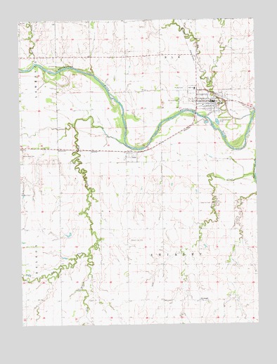
Clyde, KS USGS Topographic Map
Click on map above to begin viewing in our Map Viewer.

This topographic map contains these locations and features:
Feature Name Type Latitude Longitude GNIS ID View Map
AmesPopulated PlaceN39.5694°W97.4420°473350View Map
Beaver CreekStreamN39.5597°W97.3764°473345View Map
Cedar Hill CemeteryCemeteryN39.5494°W97.4056°473347View Map
City of ClydeCivilN39.5918°W97.4002°2393578View Map
Clifton - Clyde High SchoolSchoolN39.5967°W97.4074°480264View Map
ClydePopulated PlaceN39.5911°W97.3989°473351View Map
Clyde Christian ChurchChurchN39.5924°W97.3998°2689754View Map
Clyde City HallBuildingN39.5910°W97.3989°2693117View Map
Clyde Community Ambulance ServiceBuildingN39.5909°W97.3991°2696587View Map
Clyde Community MuseumBuildingN39.5920°W97.3984°2694304View Map
Clyde Fire DepartmentBuildingN39.5909°W97.3994°2111208View Map
Clyde Police DepartmentBuildingN39.5910°W97.3991°2503996View Map
Clyde Post OfficePost OfficeN39.5910°W97.3973°2693670View Map
Clyde United Methodist ChurchChurchN39.5909°W97.4012°2689379View Map
Clyde Wastewater Treatment FacilityLocaleN39.5830°W97.3957°2691928View Map
East Branch Elm CreekStreamN39.5289°W97.4648°473354View Map
Elk CreekStreamN39.5861°W97.3773°473104View Map
Elm CreekStreamN39.5736°W97.4434°473336View Map
Morgan ChapelChurchN39.5536°W97.4998°473348View Map
Mount Calvary Catholic CemeteryCemeteryN39.5918°W97.4144°473355View Map
Mount Hope CemeteryCemeteryN39.5967°W97.4121°473352View Map
Pleasant View CemeteryCemeteryN39.5345°W97.4431°473346View Map
Randolph - Decker Public LibraryBuildingN39.5909°W97.3987°2694708View Map
Red Stone (historical)LocaleN39.5736°W97.4989°482100View Map
Saint John the Baptist Catholic ChurchChurchN39.5928°W97.4070°2689755View Map
Saint JosephPopulated PlaceN39.5097°W97.4061°473344View Map
Saint Joseph CemeteryCemeteryN39.5089°W97.4053°2739661View Map
Township of ElkCivilN39.6183°W97.4201°473105View Map
Township of ShirleyCivilN39.5339°W97.4270°473353View Map
Upton CreekStreamN39.6075°W97.4920°473101View Map
Walnut Grove CemeteryCemeteryN39.5697°W97.4995°473349View Map

Note: Coordinates in the location and feature list above are referenced to NAD83 datum.


Copyright (C) 2008-2025 Ryan Niemi / Sunset Dynamics ... All Rights Reserved