TopoQuest Logo
Do you find TopoQuest useful?
Help keep TopoQuest running and adding new maps/features by donating!
Bitcoin:  19c7KJd3qBynnjoSw5npx9KScwjBe4ifkT
Litecoin:  LXs6TkuXGGXo1vDsWCkWVdjQX94eUKd6ui
Home View Maps Find Maps Find Places Resources & Links


Coahoma, Mississippi Topographic Map

USGS Map Title: Coahoma, MS
USGS Map MRC: 34090C5
DRG (GeoTIFF) Download: o34090c5.tif


Neighboring USGS Topographic Map Quads:


  Friars Point NW, MS  
34090D6
 

  Moon Lake, MS  
34090D5
 

  Lula, MS  
34090D4
 

  Friars Point, MS  
34090C6
 

  Coahoma, MS  
34090C5
 

  Jonestown, MS  
34090C4
 

  Sherard, MS  
34090B6
 

  Clarksdale, MS  
34090B5
 

  Sabino, MS  
34090B4


Map MRC Location:

N35°
W91°
N35°
W90°
H8 H7 H6 H5 H4 H3 H2 H1
G8 G7 G6 G5 G4 G3 G2 G1
F8 F7 F6 F5 F4 F3 F2 F1
E8 E7 E6 E5 E4 E3 E2 E1
D8 D7 D6 D5 D4 D3 D2 D1
C8 C7 C6 C5 C4 C3 C2 C1
B8 B7 B6 B5 B4 B3 B2 B1
A8 A7 A6 A5 A4 A3 A2 A1
N34°
W91°
N34°
W90°

Coahoma, MS USGS 1:24K Topographic Map Preview:
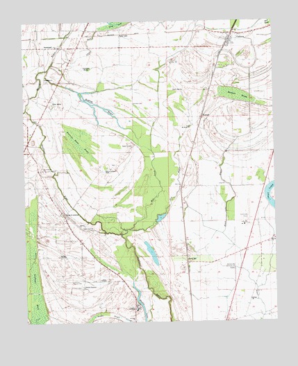
Coahoma, MS USGS Topographic Map
Click on map above to begin viewing in our Map Viewer.

This topographic map contains these locations and features:
Feature Name Type Latitude Longitude GNIS ID View Map
ArmisteadPopulated PlaceN34.3643°W90.6123°666368View Map
Armistead CemeteryCemeteryN34.3504°W90.6137°689208View Map
Armistead ChurchChurchN34.3515°W90.6143°666369View Map
Barkley BayouStreamN34.3551°W90.6132°666521View Map
Black Lake BayouStreamN34.2718°W90.5179°667236View Map
Buzzards Roost BrakeSwampN34.3248°W90.5979°667877View Map
Clover HillPopulated PlaceN34.2751°W90.5443°691772View Map
CoahomaPopulated PlaceN34.3668°W90.5232°668621View Map
Coahoma Community College Fire DepartmentBuildingN34.2575°W90.5688°2666059View Map
Coahoma County Agricultural High SchoolSchoolN34.2557°W90.5695°710429View Map
Coahoma Junior CollegeSchoolN34.2559°W90.5698°668625View Map
Coahoma Post OfficePost OfficeN34.3691°W90.5219°2768591View Map
Corndike BrakeGutN34.3554°W90.5929°668842View Map
Dickerson CemeteryCemeteryN34.2665°W90.5973°669258View Map
Dry BayouStreamN34.2884°W90.5740°669393View Map
Fant ChurchChurchN34.3068°W90.5484°669913View Map
Fant School (historical)SchoolN34.3065°W90.5473°689258View Map
Fleets ChurchChurchN34.2834°W90.5020°693232View Map
Fletcher FieldAirportN34.2924°W90.5141°680426View Map
Glen AubinPopulated PlaceN34.3412°W90.6107°670428View Map
Grassy LakeLakeN34.3251°W90.5112°689269View Map
Hamson BrakeSwampN34.3437°W90.5182°670875View Map
Heavenly Rest Memorial ParkParkN34.2732°W90.5190°671057View Map
Hull Plantation (historical)LocaleN34.3723°W90.5209°710439View Map
Irvin PlantationLocaleN34.2671°W90.5882°671721View Map
J T Farguson Pond DamDamN34.2701°W90.5601°682545View Map
J T Farguson Pond DamDamN34.2884°W90.5634°682556View Map
King and AndersonPopulated PlaceN34.2951°W90.6051°672139View Map
King and Anderson Lake DamDamN34.3084°W90.6068°682573View Map
King and Anderson RanchLocaleN34.3132°W90.5857°672140View Map
Kings Chapel (historical)ChurchN34.3123°W90.5873°689286View Map
Kings School (historical)SchoolN34.3123°W90.5876°689287View Map
Long CemeteryCemeteryN34.3073°W90.5254°672815View Map
Long LakePopulated PlaceN34.3682°W90.5779°672842View Map
Lyons BayouStreamN34.3723°W90.5887°672976View Map
Mackie LakeLakeN34.2565°W90.5670°673045View Map
Maddox PlantationLocaleN34.2773°W90.6079°673051View Map
Mill CreekStreamN34.2859°W90.5773°673629View Map
Mount Mariah CemeteryCemeteryN34.3312°W90.5431°689313View Map
Mount Moriah ChurchChurchN34.3309°W90.5432°674081View Map
Mount Zion ChurchChurchN34.2907°W90.5982°674399View Map
Oakhurst PlantationLocaleN34.2648°W90.5965°675113View Map
Old Dickerson CemeteryCemeteryN34.3143°W90.6159°675182View Map
Pilgrim Rest ChurchChurchN34.3465°W90.5468°675764View Map
Prairie PlantationLocaleN34.3232°W90.5720°676312View Map
Reese Church (historical)ChurchN34.2954°W90.5009°689334View Map
RudyardPopulated PlaceN34.3351°W90.5368°692192View Map
Saint Clair ChurchChurchN34.2590°W90.5129°677014View Map
Saint Johns ChurchChurchN34.2504°W90.5712°677090View Map
Saint Johns School (historical)SchoolN34.2507°W90.5712°689347View Map
Saunders CemeteryCemeteryN34.3407°W90.5715°677432View Map
Saunders Chapel (historical)ChurchN34.3412°W90.5695°689349View Map
Shady Grove ChurchChurchN34.2896°W90.5962°677591View Map
Sheriff Ridge School (historical)SchoolN34.2896°W90.5968°689351View Map
Supervisor District 1CivilN34.3745°W90.5026°711823View Map
Swan Lake School (historical)SchoolN34.3054°W90.5057°689365View Map
Town of CoahomaCivilN34.3663°W90.5220°2406285View Map
Whittaker BayouStreamN34.3387°W90.6237°679652View Map

Note: Coordinates in the location and feature list above are referenced to NAD83 datum.


Copyright (C) 2008-2024 Ryan Niemi / Sunset Dynamics ... All Rights Reserved