TopoQuest Logo
Do you find TopoQuest useful?
Help keep TopoQuest running and adding new maps/features by donating!
Bitcoin:  19c7KJd3qBynnjoSw5npx9KScwjBe4ifkT
Litecoin:  LXs6TkuXGGXo1vDsWCkWVdjQX94eUKd6ui
Home View Maps Find Maps Find Places Resources & Links


Friars Point NW, Mississippi Topographic Map

USGS Map Title: Friars Point NW, MS
USGS Map MRC: 34090D6
DRG (GeoTIFF) Download: o34090d6.tif


Neighboring USGS Topographic Map Quads:


  Lexa, AR  
34090E7
 

  West Helena, AR  
34090E6
 

  Helena, AR  
34090E5
 

  Lakeview, AR  
34090D7
 

  Friars Point NW, MS  
34090D6
 

  Moon Lake, MS  
34090D5
 

  Elaine, AR  
34090C7
 

  Friars Point, MS  
34090C6
 

  Coahoma, MS  
34090C5


Map MRC Location:

N35°
W91°
N35°
W90°
H8 H7 H6 H5 H4 H3 H2 H1
G8 G7 G6 G5 G4 G3 G2 G1
F8 F7 F6 F5 F4 F3 F2 F1
E8 E7 E6 E5 E4 E3 E2 E1
D8 D7 D6 D5 D4 D3 D2 D1
C8 C7 C6 C5 C4 C3 C2 C1
B8 B7 B6 B5 B4 B3 B2 B1
A8 A7 A6 A5 A4 A3 A2 A1
N34°
W91°
N34°
W90°

Friars Point NW, MS USGS 1:24K Topographic Map Preview:
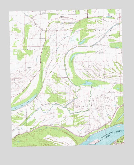
Friars Point NW, MS USGS Topographic Map
Click on map above to begin viewing in our Map Viewer.

This topographic map contains these locations and features:
Feature Name Type Latitude Longitude GNIS ID View Map
Beaver Bayou DitchGutN34.4945°W90.7237°56799View Map
Bee Tree Church (historical)ChurchN34.4562°W90.6901°70109View Map
Brown CemeteryCemeteryN34.4637°W90.6298°46993View Map
Brown Chapel (historical)ChurchN34.4632°W90.6307°65607View Map
Cooper CemeteryCemeteryN34.4590°W90.6276°48009View Map
District 44 School (historical)SchoolN34.4362°W90.7121°70112View Map
Elaine MissionChurchN34.4145°W90.7065°48833View Map
Fitzhugh School (historical)SchoolN34.4159°W90.6807°65623View Map
Kangaroo PointCliffN34.3776°W90.6720°50766View Map
Kangaroo Point LandingLocaleN34.3765°W90.6734°70115View Map
Kangaroo Point Upper BarBarN34.3779°W90.6545°689381View Map
Little Zion ChurchChurchN34.4362°W90.7123°51347View Map
Little Zion School (historical)SchoolN34.4357°W90.7126°65632View Map
Llewellyn Church (historical)ChurchN34.3940°W90.7462°1805741View Map
Llewellyn School (historical)SchoolN34.3940°W90.7459°65633View Map
Long LakeGutN34.4048°W90.7268°51430View Map
Long LakeLakeN34.4833°W90.6357°74989View Map
Long Lake ChurchChurchN34.4920°W90.6318°51436View Map
Long Lake School (historical)SchoolN34.4668°W90.6596°65634View Map
Maney CemeteryCemeteryN34.3943°W90.7076°51636View Map
Maney ChurchChurchN34.4012°W90.6896°51637View Map
Maynard CemeteryCemeteryN34.3793°W90.6287°673268View Map
Missouri SloughStreamN34.3920°W90.7390°52102View Map
Morning Grove CemeteryCemeteryN34.4473°W90.7259°65659View Map
Morning Grove ChurchChurchN34.4476°W90.7257°52196View Map
Mount Lula ChurchChurchN34.3909°W90.7476°52314View Map
New Hope ChurchChurchN34.4579°W90.6898°52683View Map
Paradise ChurchChurchN34.4601°W90.6490°53177View Map
Paradise School (historical)SchoolN34.4598°W90.6496°65643View Map
Point Pleasant ChurchChurchN34.4179°W90.6457°78068View Map
Preston PlacePopulated PlaceN34.4757°W90.6437°58428View Map
Saint Marys CemeteryCemeteryN34.4823°W90.7118°65649View Map
Saint Marys ChurchChurchN34.4934°W90.6940°65650View Map
Saint Marys ChurchChurchN34.4815°W90.7107°54415View Map
Saint Marys SchoolSchoolN34.4937°W90.6937°54419View Map
Saint Stephens School (historical)SchoolN34.4018°W90.6896°1805742View Map
Township of LakeCivilN34.4085°W90.6657°68953View Map
Union School (historical)SchoolN34.4893°W90.7243°1805743View Map
United States National River AcademySchoolN34.3965°W90.6457°65653View Map
WestoverPopulated PlaceN34.3879°W90.6654°65654View Map
Westover BayouStreamN34.4015°W90.6523°65655View Map
Westover LandingLocaleN34.3912°W90.6287°70136View Map
Westover RevetmentLeveeN34.3895°W90.6537°65656View Map

Note: Coordinates in the location and feature list above are referenced to NAD83 datum.


Copyright (C) 2008-2024 Ryan Niemi / Sunset Dynamics ... All Rights Reserved