TopoQuest Logo
Do you find TopoQuest useful?
Help keep TopoQuest running and adding new maps/features by donating!
Bitcoin:  19c7KJd3qBynnjoSw5npx9KScwjBe4ifkT
Litecoin:  LXs6TkuXGGXo1vDsWCkWVdjQX94eUKd6ui
Home View Maps Find Maps Find Places Resources & Links


Coble, Tennessee Topographic Map

USGS Map Title: Coble, TN
USGS Map MRC: 35087G6
DRG (GeoTIFF) Download: o35087g6.tif


Neighboring USGS Topographic Map Quads:


  Hurricane Mills, TN  
35087H7
 

  Bucksnort, TN  
35087H6
 

  Spot, TN  
35087H5
 

  Lobelville, TN  
35087G7
 

  Coble, TN  
35087G6
 

  Whitfield, TN  
35087G5
 

  Chestnut Grove, TN  
35087F7
 

  Pleasantville, TN  
35087F6
 

  Beaverdam Springs, TN  
35087F5


Map MRC Location:

N36°
W88°
N36°
W87°
H8 H7 H6 H5 H4 H3 H2 H1
G8 G7 G6 G5 G4 G3 G2 G1
F8 F7 F6 F5 F4 F3 F2 F1
E8 E7 E6 E5 E4 E3 E2 E1
D8 D7 D6 D5 D4 D3 D2 D1
C8 C7 C6 C5 C4 C3 C2 C1
B8 B7 B6 B5 B4 B3 B2 B1
A8 A7 A6 A5 A4 A3 A2 A1
N35°
W88°
N35°
W87°

Coble, TN USGS 1:24K Topographic Map Preview:
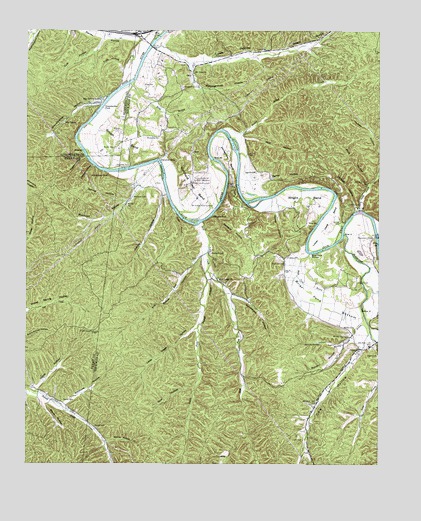
Coble, TN USGS Topographic Map
Click on map above to begin viewing in our Map Viewer.

This topographic map contains these locations and features:
Feature Name Type Latitude Longitude GNIS ID View Map
Alexander FordCrossingN35.8353°W87.7139°1314575View Map
Ammons HollowValleyN35.7671°W87.7362°1304822View Map
Barber CemeteryCemeteryN35.7684°W87.7370°1276280View Map
Barren HollowValleyN35.8731°W87.7100°1276380View Map
Beaverdam BridgeBridgeN35.8156°W87.6253°1276722View Map
Beaverdam CreekStreamN35.8165°W87.6372°1276726View Map
Beckie HollowValleyN35.7565°W87.7212°1276745View Map
Big SpringSpringN35.8484°W87.7364°1277402View Map
Big Spring LakeLakeN35.8539°W87.7252°1277420View Map
Big Spring Lake Number TwoReservoirN35.8534°W87.7300°1302172View Map
Big Spring Lake Number Two DamDamN35.8534°W87.7300°1302173View Map
Blackwell CemeteryCemeteryN35.8073°W87.6586°1277623View Map
Blackwell CemeteryCemeteryN35.8109°W87.6847°1277624View Map
Blackwell CemeteryCemeteryN35.8267°W87.7125°1277625View Map
Blackwell HollowValleyN35.8305°W87.7095°1277627View Map
Blowing SpringSpringN35.7850°W87.6458°1277729View Map
Blowing Spring BranchStreamN35.7931°W87.6303°1277732View Map
Blue Rock ShoalsBarN35.8117°W87.6495°1277774View Map
Briar Pond BottomBendN35.7973°W87.6481°1278314View Map
Briar Pond BranchStreamN35.8106°W87.6497°1278315View Map
Brown BendBendN35.8437°W87.7175°1305438View Map
Brown CemeteryCemeteryN35.8409°W87.7189°1278542View Map
Burchard FordCrossingN35.8256°W87.6722°1311343View Map
Burchard Town BendBendN35.8298°W87.6903°1279023View Map
Cagle CemeteryCemeteryN35.7817°W87.6253°1279287View Map
Caney HollowValleyN35.8229°W87.6614°1279583View Map
Carothers CemeteryCemeteryN35.8248°W87.6367°1305690View Map
Carter HollowValleyN35.8300°W87.6670°1279814View Map
CoblePopulated PlaceN35.7831°W87.6325°1280837View Map
Coble HollowValleyN35.7715°W87.7458°1280838View Map
Coble School (historical)SchoolN35.7842°W87.6284°1319063View Map
Cow HollowValleyN35.7840°W87.6314°1281446View Map
Cow Hollow Branch StreamStreamN35.7876°W87.6278°1311347View Map
Cude HollowValleyN35.8636°W87.7159°1306218View Map
Cuff HollowValleyN35.8727°W87.7232°1281810View Map
East Fork Wolf CreekStreamN35.8059°W87.6861°1283372View Map
Flowers CemeteryCemeteryN35.8098°W87.6578°1284511View Map
Grandmother BranchStreamN35.8534°W87.7236°1310648View Map
Grandmother FordCrossingN35.8528°W87.7236°1315140View Map
Grandmother HollowValleyN35.8539°W87.7239°1285824View Map
Grandmothers BuildingCliffN35.8492°W87.7286°1644753View Map
Greasy HollowValleyN35.8278°W87.7004°1286041View Map
Gullet ChuteChannelN35.8426°W87.6770°1311355View Map
Gunter CemeteryCemeteryN35.7606°W87.7256°1286441View Map
Happy Hollow CreekStreamN35.8465°W87.6809°1286773View Map
Horseshoe BendBendN35.8401°W87.6811°1288431View Map
Interchange 148CrossingN35.8742°W87.7097°1311362View Map
Jacklot HollowValleyN35.8237°W87.6330°1289167View Map
King BranchStreamN35.8598°W87.7134°1290191View Map
King CemeteryCemeteryN35.8592°W87.7089°1290203View Map
Limekiln HollowValleyN35.8360°W87.7266°1291290View Map
Little Creek HollowValleyN35.7892°W87.6901°1291462View Map
Little Piney CreekStreamN35.8237°W87.6317°1291617View Map
Lowe CemeteryCemeteryN35.8689°W87.6686°1292199View Map
Lowe HollowValleyN35.8695°W87.7039°1292205View Map
Lower Lowe BendBendN35.8178°W87.6428°1292223View Map
Lynn CemeteryCemeteryN35.7573°W87.6517°1292348View Map
Macedonia School (historical)SchoolN35.8106°W87.6622°1319102View Map
Marrs HollowValleyN35.7679°W87.7430°1292733View Map
Meetinghouse HollowValleyN35.8652°W87.6918°1293546View Map
Middle Fork Wolf CreekStreamN35.8059°W87.6859°1293682View Map
Mount Zion ChurchChurchN35.8628°W87.6917°1294895View Map
Mule HollowValleyN35.8310°W87.6291°1295067View Map
Murphree CemeteryCemeteryN35.8439°W87.7033°1295109View Map
Murphree EddyRapidsN35.8373°W87.7036°1295110View Map
OnlyPopulated PlaceN35.8617°W87.6917°1296439View Map
Only Post OfficePost OfficeN35.8634°W87.6914°1651178View Map
Only School (historical)SchoolN35.8587°W87.6945°1319120View Map
Perogue FordCrossingN35.8220°W87.6850°1315696View Map
Perogue HollowValleyN35.8221°W87.6835°1297197View Map
Pigpen HollowValleyN35.8386°W87.7291°1297456View Map
Powell HollowValleyN35.8037°W87.6859°1298416View Map
Rich HollowValleyN35.8440°W87.6726°1299318View Map
Rocky BranchStreamN35.8223°W87.6970°1299859View Map
Runion HollowValleyN35.7836°W87.6382°1300248View Map
Russell CemeteryCemeteryN35.8026°W87.6325°1300314View Map
Russell Creek Church (historical)ChurchN35.7681°W87.7372°1308611View Map
Sawyer HollowValleyN35.8100°W87.6882°1300852View Map
Schoolhouse RidgeRidgeN35.7751°W87.7334°1308613View Map
Shanes CemeteryCemeteryN35.8303°W87.6764°1301213View Map
Sparks CemeteryCemeteryN35.8339°W87.6692°1270959View Map
Spicewood HollowValleyN35.7986°W87.6778°1270999View Map
Spring HollowValleyN35.8260°W87.7141°1271120View Map
Strickland/Smalley Field Airport (historical)AirportN35.8503°W87.7222°2675489View Map
Turney Center for Youthful OffendersLocaleN35.8315°W87.6884°1273094View Map
Turney Center Industrial ComplexBuildingN35.8312°W87.6903°2766069View Map
Walker CemeteryCemeteryN35.7887°W87.6336°1273595View Map
Walker SpringSpringN35.7868°W87.6357°1273648View Map
West Fork Wolf CreekStreamN35.8112°W87.6861°1274195View Map
Wilkins CemeteryCemeteryN35.8462°W87.7170°1274596View Map
Wolf CreekStreamN35.8201°W87.6881°1274944View Map
Wolf Creek CemeteryCemeteryN35.8034°W87.6822°1319151View Map
Wolf Creek ChurchChurchN35.8031°W87.6822°1274955View Map
Wolf HollowValleyN35.7719°W87.6905°1274965View Map
Wright BendBendN35.8259°W87.6514°1275150View Map
Wright HollowValleyN35.8681°W87.6656°1275182View Map

Note: Coordinates in the location and feature list above are referenced to NAD83 datum.


Copyright (C) 2008-2025 Ryan Niemi / Sunset Dynamics ... All Rights Reserved