TopoQuest Logo
Do you find TopoQuest useful?
Help keep TopoQuest running and adding new maps/features by donating!
Bitcoin:  19c7KJd3qBynnjoSw5npx9KScwjBe4ifkT
Litecoin:  LXs6TkuXGGXo1vDsWCkWVdjQX94eUKd6ui
Home View Maps Find Maps Find Places Resources & Links


Hurricane Mills, Tennessee Topographic Map

USGS Map Title: Hurricane Mills, TN
USGS Map MRC: 35087H7
DRG (GeoTIFF) Download: o35087h7.tif


Neighboring USGS Topographic Map Quads:


  Johnsonville, TN  
36087A8
 

  Waverly, TN  
36087A7
 

  McEwen, TN  
36087A6
 

  Hustburg, TN  
35087H8
 

  Hurricane Mills, TN  
35087H7
 

  Bucksnort, TN  
35087H6
 

  Daniels Landing, TN  
35087G8
 

  Lobelville, TN  
35087G7
 

  Coble, TN  
35087G6


Map MRC Location:

N36°
W88°
N36°
W87°
H8 H7 H6 H5 H4 H3 H2 H1
G8 G7 G6 G5 G4 G3 G2 G1
F8 F7 F6 F5 F4 F3 F2 F1
E8 E7 E6 E5 E4 E3 E2 E1
D8 D7 D6 D5 D4 D3 D2 D1
C8 C7 C6 C5 C4 C3 C2 C1
B8 B7 B6 B5 B4 B3 B2 B1
A8 A7 A6 A5 A4 A3 A2 A1
N35°
W88°
N35°
W87°

Hurricane Mills, TN USGS 1:24K Topographic Map Preview:
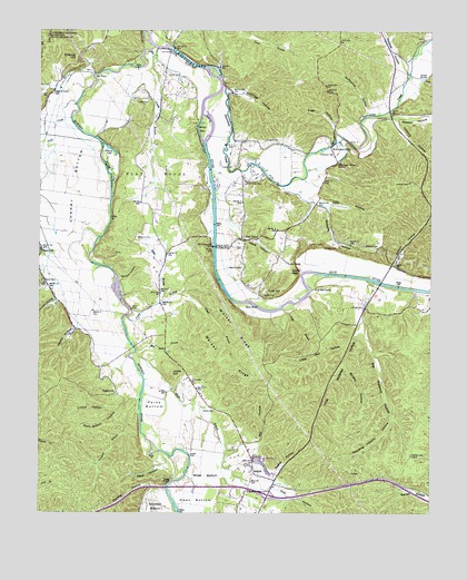
Hurricane Mills, TN USGS Topographic Map
Click on map above to begin viewing in our Map Viewer.

This topographic map contains these locations and features:
Feature Name Type Latitude Longitude GNIS ID View Map
Anderson CemeteryCemeteryN35.9684°W87.7814°1275705View Map
Baker BranchStreamN35.9292°W87.8381°1276139View Map
BakervillePopulated PlaceN35.9437°W87.8742°1276198View Map
Bakerville-Bold Spring Division (historical)CensusN35.9667°W87.7889°1269257View Map
Beech Hill School (historical)SchoolN35.9587°W87.8097°1316912View Map
Betherberry Church (historical)ChurchN35.9934°W87.7570°1316916View Map
Big Watered HollowValleyN35.9344°W87.7705°1305242View Map
Black BranchStreamN35.9165°W87.8439°1277546View Map
Bodine SchoolSchoolN35.8806°W87.8078°1277874View Map
Bone CemeteryCemeteryN35.9348°W87.8734°1277938View Map
Bone HollowValleyN35.9342°W87.8726°1277940View Map
Bones FordCrossingN35.9348°W87.7659°1310634View Map
Brushy HollowValleyN35.9135°W87.7783°1278705View Map
Bud Rock BranchStreamN35.9170°W87.8442°1278896View Map
BuffaloPopulated PlaceN35.8856°W87.8067°1314764View Map
Buffalo Church (historical)ChurchN35.8987°W87.8120°1316919View Map
Buffalo RiverStreamN35.9956°W87.8392°1305509View Map
CaigletownPopulated PlaceN35.9059°W87.8503°1314781View Map
Camp BranchStreamN35.9259°W87.8467°1305621View Map
Capps HollowValleyN35.9377°W87.8749°1279640View Map
Cedar GapGapN35.9373°W87.7947°1280025View Map
Cedar GrovePopulated PlaceN35.9462°W87.8109°1314809View Map
Cedar Grove Baptist ChurchChurchN35.9484°W87.8070°1644747View Map
Cherry BottomBasinN35.9584°W87.8653°1280331View Map
Coaling HollowValleyN35.9768°W87.7603°1280811View Map
Cold BranchStreamN35.9276°W87.7978°1280881View Map
Commissioner District 5CivilN35.9474°W87.7961°2464459View Map
Cow HollowValleyN35.8816°W87.8009°1281447View Map
Crockett CemeteryCemeteryN35.9714°W87.7992°1306182View Map
Dudley CemeteryCemeteryN35.9334°W87.8022°1283060View Map
Flat WoodsWoodsN35.9606°W87.8359°1284427View Map
Foster CemeteryCemeteryN35.9773°W87.7642°1284697View Map
Foster CemeteryCemeteryN35.9817°W87.8406°1284698View Map
Fowler CemeteryCemeteryN35.9645°W87.8134°1284745View Map
Fowlkes HillSummitN35.9926°W87.8664°1284757View Map
Goodrich Mill (historical)LocaleN35.9648°W87.8117°1644751View Map
Grassy BranchStreamN35.9951°W87.8397°1285878View Map
Grassy Branch School (historical)SchoolN35.9820°W87.8361°1316941View Map
Hachie ShoalBarN35.9365°W87.7750°1644754View Map
Happy HollowValleyN35.9228°W87.8634°1286766View Map
Hegleys Mill (historical)LocaleN35.9726°W87.8567°1316946View Map
Hite FordCrossingN35.9287°W87.8053°1315241View Map
Hite HollowValleyN35.9566°W87.7876°1287911View Map
Hobbs CemeteryCemeteryN35.9889°W87.8339°1287935View Map
Humphreys County Fire Department District 6BuildingN35.8816°W87.7838°2654222View Map
Hurricane CreekStreamN35.9862°W87.8172°1306597View Map
Hurricane MillsPopulated PlaceN35.9712°W87.7820°1288832View Map
Hurricane Mills Post OfficePost OfficeN35.9713°W87.7824°1650642View Map
Hurricane Mills SchoolSchoolN35.9659°W87.7792°1288833View Map
Hutchinson HollowValleyN35.9854°W87.8702°1288866View Map
Interchange 143CrossingN35.8798°W87.8017°1310656View Map
Jackson HollowValleyN35.9301°W87.8691°1289232View Map
Jones HillSummitN35.9112°W87.8322°1289793View Map
Ladd CemeteryCemeteryN35.9837°W87.8725°1290456View Map
Link BridgeBridgeN35.9951°W87.8328°1291341View Map
Little Mill HollowValleyN35.9180°W87.7766°1291567View Map
Little Watered HollowValleyN35.9234°W87.7734°1291706View Map
Low GapGapN35.9401°W87.7964°1292172View Map
Luten BranchStreamN35.9967°W87.8350°1292304View Map
Martin FordCrossingN35.9276°W87.8456°1310660View Map
Martin Ford Bridge (historical)BridgeN35.9276°W87.8456°1316960View Map
Mason HollowValleyN35.9390°W87.7610°1292890View Map
Massey CemeteryCemeteryN35.9317°W87.8042°1292906View Map
McCawleys Mill (historical)LocaleN35.9273°W87.8450°1316964View Map
McMurray HollowValleyN35.9798°W87.7711°1293424View Map
Mill BranchStreamN35.9042°W87.8425°1310661View Map
Mill HollowValleyN35.8936°W87.8035°1293875View Map
Nolan SpringSpringN35.9877°W87.7520°1295804View Map
O'Donniley CemeteryCemeteryN35.9606°W87.8097°1296035View Map
Owen BottomBendN35.8756°W87.8253°1296558View Map
Pace BluffCliffN35.8828°W87.8336°1296632View Map
Pace FordCrossingN35.8890°W87.8334°1310667View Map
Pace HollowValleyN35.8877°W87.8363°1296636View Map
Page HollowValleyN35.9743°W87.7803°1296649View Map
Parks BottomBendN35.9028°W87.8384°1296845View Map
Parm Lick PondReservoirN35.8903°W87.7563°1296868View Map
Pegram School (historical)SchoolN35.9420°W87.8342°1316978View Map
Pierce HollowValleyN35.9012°W87.8522°1297427View Map
Railpen HollowValleyN35.9359°W87.8495°1298819View Map
Reece HollowValleyN35.8828°W87.8004°1299113View Map
Riverview School (historical)SchoolN35.9237°W87.7739°1316990View Map
Roberts CemeteryCemeteryN35.9437°W87.7800°1299630View Map
Roberts HollowValleyN35.9540°W87.7829°1299644View Map
Roberts HollowValleyN35.9898°W87.7576°1299647View Map
Rock Quarry HollowValleyN35.9049°W87.8440°1299777View Map
Rushing CemeteryCemeteryN35.9439°W87.7672°1300277View Map
Rushing HillSummitN35.9476°W87.7697°1310736View Map
Shannon CemeteryCemeteryN35.9387°W87.8103°1301229View Map
Shipp BottomBendN35.8848°W87.8222°1270125View Map
Sterling HollowValleyN35.8822°W87.8366°1271344View Map
Stewart BranchStreamN35.9784°W87.7656°1647377View Map
Stewart HollowValleyN35.9787°W87.7640°1271373View Map
Stooping Hickory HollowValleyN35.8998°W87.7617°1271529View Map
Tanksley BridgeBridgeN35.9440°W87.8192°1303999View Map
Tanyard BranchStreamN35.9017°W87.8431°1272099View Map
The WhirlBendN35.9884°W87.8581°1272450View Map
Toland HollowValleyN35.9489°W87.8130°1272724View Map
Voorhies HollowValleyN35.9843°W87.8153°1273498View Map
Walker CemeteryCemeteryN35.9012°W87.8184°1273596View Map
Walker RidgeRidgeN35.9159°W87.8172°1273644View Map
Whery LakeLakeN35.9698°W87.8531°1274298View Map
Whirl BarIslandN35.9745°W87.8231°1274306View Map
Will Rice EddyRapidsN35.9328°W87.7886°1274607View Map
Williams CemeteryCemeteryN35.9462°W87.8439°1274663View Map
Wright CemeteryCemeteryN35.9284°W87.7753°1275160View Map

Note: Coordinates in the location and feature list above are referenced to NAD83 datum.


Copyright (C) 2008-2024 Ryan Niemi / Sunset Dynamics ... All Rights Reserved