TopoQuest Logo
Do you find TopoQuest useful?
Help keep TopoQuest running and adding new maps/features by donating!
Bitcoin:  19c7KJd3qBynnjoSw5npx9KScwjBe4ifkT
Litecoin:  LXs6TkuXGGXo1vDsWCkWVdjQX94eUKd6ui
Home View Maps Find Maps Find Places Resources & Links


Cocolalla, Idaho Topographic Map

USGS Map Title: Cocolalla, ID
USGS Map MRC: 48116A5
DRG (GeoTIFF) Download: o48116a5.tif


Neighboring USGS Topographic Map Quads:


  Morton, ID  
48116B6
 

  Sagle, ID  
48116B5
 

  Talache, ID  
48116B4
 

  Careywood, ID  
48116A6
 

  Cocolalla, ID  
48116A5
 

  Minerva Peak, ID  
48116A4
 

  Athol, ID  
47116H6
 

  Bayview, ID  
47116H5
 

  Lakeview, ID  
47116H4


Map MRC Location:

N49°
W117°
N49°
W116°
H8 H7 H6 H5 H4 H3 H2 H1
G8 G7 G6 G5 G4 G3 G2 G1
F8 F7 F6 F5 F4 F3 F2 F1
E8 E7 E6 E5 E4 E3 E2 E1
D8 D7 D6 D5 D4 D3 D2 D1
C8 C7 C6 C5 C4 C3 C2 C1
B8 B7 B6 B5 B4 B3 B2 B1
A8 A7 A6 A5 A4 A3 A2 A1
N48°
W117°
N48°
W116°

Cocolalla, ID USGS 1:24K Topographic Map Preview:
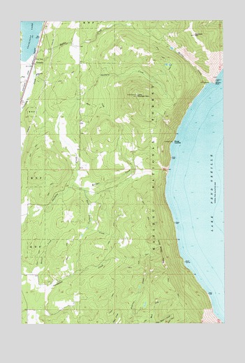
Cocolalla, ID USGS Topographic Map
Click on map above to begin viewing in our Map Viewer.

This topographic map contains these locations and features:
Feature Name Type Latitude Longitude GNIS ID View Map
Beaver CreekStreamN48.0213°W116.6191°377239View Map
Blacktail MountainSummitN48.1188°W116.5188°396147View Map
Butler CreekStreamN48.1096°W116.6144°397506View Map
Cape Horn CreekStreamN48.0010°W116.5463°378895View Map
CocolallaPopulated PlaceN48.1080°W116.6174°396313View Map
Drake CemeteryCemeteryN48.1181°W116.5413°400529View Map
Evans LandingPopulated PlaceN48.0755°W116.5316°396472View Map
Evans Landing Picnic AreaLocaleN48.0749°W116.5324°394185View Map
Fish CreekStreamN48.1069°W116.6194°381746View Map
Kreiger CreekStreamN48.0580°W116.5944°384310View Map
Little Blacktail MountainSummitN48.0944°W116.5538°396800View Map
Maiden CreekStreamN48.0988°W116.5113°386389View Map
Maiden RockCapeN48.0994°W116.5066°386390View Map
Maiden Rock Picnic AreaLocaleN48.0994°W116.5096°394184View Map
Micro CreekStreamN48.0913°W116.5916°386779View Map
Southside Elementary SchoolSchoolN48.1030°W116.6157°400685View Map
Three Sisters CreekStreamN48.0563°W116.5896°392093View Map
Three Sisters PeaksSummitN48.0296°W116.5408°397255View Map
Timberlake Fire Protection District Station 6BuildingN48.0654°W116.5510°2619226View Map

Note: Coordinates in the location and feature list above are referenced to NAD83 datum.


Copyright (C) 2008-2025 Ryan Niemi / Sunset Dynamics ... All Rights Reserved