TopoQuest Logo
Do you find TopoQuest useful?
Help keep TopoQuest running and adding new maps/features by donating!
Bitcoin:  19c7KJd3qBynnjoSw5npx9KScwjBe4ifkT
Litecoin:  LXs6TkuXGGXo1vDsWCkWVdjQX94eUKd6ui
Home View Maps Find Maps Find Places Resources & Links


Coffeeville, Alabama Topographic Map

USGS Map Title: Coffeeville, AL
USGS Map MRC: 31088G1
DRG (GeoTIFF) Download: o31088g1.tif


Neighboring USGS Topographic Map Quads:


  Ararat, AL  
31088H2
 

  Woods Bluff, AL  
31088H1
 

  Morvin, AL  
31087H8
 

  Coffeeville Lock And Dam, AL  
31088G2
 

  Coffeeville, AL  
31088G1
 

  McEntyre, AL  
31087G8
 

  Bladon Springs, AL  
31088F2
 

  Tattlersville, AL  
31088F1
 

  Winn, AL  
31087F8


Map MRC Location:

N32°
W89°
N32°
W88°
H8 H7 H6 H5 H4 H3 H2 H1
G8 G7 G6 G5 G4 G3 G2 G1
F8 F7 F6 F5 F4 F3 F2 F1
E8 E7 E6 E5 E4 E3 E2 E1
D8 D7 D6 D5 D4 D3 D2 D1
C8 C7 C6 C5 C4 C3 C2 C1
B8 B7 B6 B5 B4 B3 B2 B1
A8 A7 A6 A5 A4 A3 A2 A1
N31°
W89°
N31°
W88°

Coffeeville, AL USGS 1:24K Topographic Map Preview:
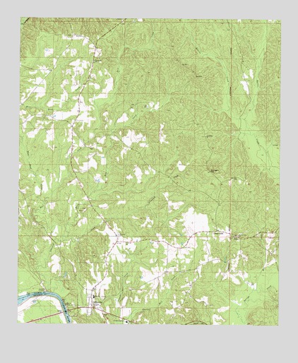
Coffeeville, AL USGS Topographic Map
Click on map above to begin viewing in our Map Viewer.

This topographic map contains these locations and features:
Feature Name Type Latitude Longitude GNIS ID View Map
Anderson CemeteryCemeteryN31.8268°W88.0364°133573View Map
Ball BluffCliffN31.7549°W88.0995°133577View Map
BethelLocaleN31.8240°W88.0881°133582View Map
Bethel Baptist ChurchChurchN31.8221°W88.0906°114047View Map
Center PointPopulated PlaceN31.7885°W88.0300°115851View Map
Center Point ChurchChurchN31.7865°W88.0195°115856View Map
CoffeevillePopulated PlaceN31.7579°W88.0897°116356View Map
Coffeeville CemeteryCemeteryN31.7596°W88.0872°133605View Map
Coffeeville ChurchChurchN31.8579°W88.0900°116357View Map
Coffeeville DivisionCivilN31.8339°W88.0610°165699View Map
Coffeeville Elementary SchoolSchoolN31.7511°W88.0728°133606View Map
Coffeeville Ferry (historical)CrossingN31.7579°W88.1042°139985View Map
Coffeeville High SchoolSchoolN31.7611°W88.0883°2358912View Map
Coffeeville LandingLocaleN31.7565°W88.1017°156198View Map
Coffeeville Post OfficePost OfficeN31.7585°W88.0885°2789095View Map
Coffeeville Volunteer Fire DepartmentBuildingN31.7579°W88.0878°2691087View Map
Dunagan HillSummitN31.8129°W88.0336°117648View Map
Estis Mill CreekStreamN31.7838°W88.1039°118043View Map
Flat Woods CreekStreamN31.7607°W88.1247°118398View Map
Folsom BridgeBridgeN31.7552°W88.1020°118470View Map
FriendshipLocaleN31.8271°W88.0364°133627View Map
Friendship Baptist ChurchChurchN31.8271°W88.0356°118660View Map
James CemeteryCemeteryN31.7582°W88.0331°163607View Map
Jones Chapel Church of ChristChurchN31.7860°W88.0217°151912View Map
Kiels CemeteryCemeteryN31.7593°W88.0450°133659View Map
Mill CreekStreamN31.7646°W88.0108°122761View Map
Nichols LandingLocaleN31.7629°W88.1125°156794View Map
Owl HillSummitN31.8507°W88.0411°124356View Map
Pace CreekStreamN31.7846°W88.1070°124367View Map
Pace Creek Oil FieldOilfieldN31.8418°W88.0781°151171View Map
Panther StadiumParkN31.7622°W88.0889°2358913View Map
Roberts CreekStreamN31.8343°W88.0172°125699View Map
Rockbar ChurchChurchN31.8732°W88.0761°163129View Map
Toland CreekStreamN31.7502°W88.0747°128009View Map
Town of CoffeevilleCivilN31.7666°W88.0860°2406289View Map
Trotter CemeteryCemeteryN31.8682°W88.1003°163627View Map
Ulcanush Baptist ChurchChurchN31.7868°W88.0770°153754View Map
Ulcanush CemeteryCemeteryN31.7871°W88.0769°133725View Map
Ulcanush CreekStreamN31.7627°W88.1081°153753View Map
Union Baptist ChurchChurchN31.7543°W88.0828°153761View Map
Webb CemeteryCemeteryN31.8196°W88.0900°133730View Map
West Bend CreekStreamN31.8271°W88.1247°128755View Map

Note: Coordinates in the location and feature list above are referenced to NAD83 datum.


Copyright (C) 2008-2024 Ryan Niemi / Sunset Dynamics ... All Rights Reserved