TopoQuest Logo
Do you find TopoQuest useful?
Help keep TopoQuest running and adding new maps/features by donating!
Bitcoin:  19c7KJd3qBynnjoSw5npx9KScwjBe4ifkT
Litecoin:  LXs6TkuXGGXo1vDsWCkWVdjQX94eUKd6ui
Home View Maps Find Maps Find Places Resources & Links


Cohutta, Georgia Topographic Map

USGS Map Title: Cohutta, GA
USGS Map MRC: 34084H8
DRG (GeoTIFF) Download: o34084h8.tif


Neighboring USGS Topographic Map Quads:


  Ooltewah, TN  
35085A1
 

  McDonald, TN  
35084A8
 

  Felker, TN  
35084A7
 

  Ringgold, GA  
34085H1
 

  Cohutta, GA  
34084H8
 

  Beaverdale, GA  
34084H7
 

  Tunnel Hill, GA  
34085G1
 

  Dalton North, GA  
34084G8
 

  Chatsworth, GA  
34084G7


Map MRC Location:

N35°
W85°
N35°
W84°
H8 H7 H6 H5 H4 H3 H2 H1
G8 G7 G6 G5 G4 G3 G2 G1
F8 F7 F6 F5 F4 F3 F2 F1
E8 E7 E6 E5 E4 E3 E2 E1
D8 D7 D6 D5 D4 D3 D2 D1
C8 C7 C6 C5 C4 C3 C2 C1
B8 B7 B6 B5 B4 B3 B2 B1
A8 A7 A6 A5 A4 A3 A2 A1
N34°
W85°
N34°
W84°

Cohutta, GA USGS 1:24K Topographic Map Preview:
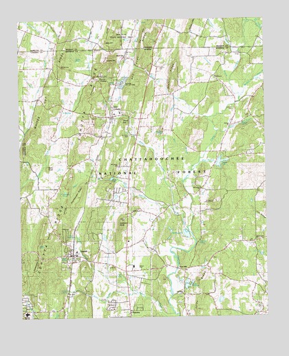
Cohutta, GA USGS Topographic Map
Click on map above to begin viewing in our Map Viewer.

This topographic map contains these locations and features:
Feature Name Type Latitude Longitude GNIS ID View Map
Adams PondLakeN34.9828°W84.9695°326913View Map
Anderson BridgeBridgeN34.9442°W84.9052°1704608View Map
Andrew ChapelChurchN34.9631°W84.9524°330956View Map
Barrett LakeReservoirN34.9098°W84.9157°337029View Map
Barrett Lake DamDamN34.9101°W84.9149°337028View Map
Barrett LakesReservoirN34.9116°W84.9237°354470View Map
Bartlett BranchStreamN34.9755°W84.8789°327016View Map
Big HillSummitN34.9887°W84.9366°1277303View Map
Blue BranchStreamN34.9370°W84.9122°327166View Map
Blue HoleLakeN34.9052°W84.9885°327168View Map
Blue SpringSpringN34.9090°W84.9727°327182View Map
Bridges SpringSpringN34.9617°W84.9730°327220View Map
Brown PondLakeN34.9019°W84.8789°327237View Map
City of CohuttaCivilN34.9539°W84.9593°2404092View Map
City of VarnellCivilN34.8955°W84.9649°2405639View Map
CohuttaPopulated PlaceN34.9595°W84.9527°331428View Map
Cohutta Baptist ChurchChurchN34.9604°W84.9513°353380View Map
Cohutta ChurchChurchN34.9804°W84.9847°353237View Map
Cohutta Elementary SchoolSchoolN34.9615°W84.9489°353381View Map
Cohutta National Fish HatcheryLocaleN34.9729°W84.9480°344213View Map
Cohutta Police DepartmentBuildingN34.9600°W84.9523°2733911View Map
Cohutta Post OfficePost OfficeN34.9592°W84.9528°353382View Map
Cohutta Volunteer Fire DepartmentBuildingN34.9600°W84.9523°2603790View Map
Concord CemeteryCemeteryN34.9626°W84.8908°327508View Map
Concord ChurchChurchN34.9556°W84.8927°355267View Map
Copeland SpringsSpringN34.9337°W84.9536°353384View Map
Council SpringSpringN34.9917°W84.9461°1307799View Map
Dry BranchStreamN34.9558°W84.9796°327687View Map
Dry ValleyValleyN34.9642°W84.9716°1283024View Map
Edgar (historical)Populated PlaceN34.9442°W84.8949°353404View Map
Emerson BridgeBridgeN34.9856°W84.8863°327760View Map
Estelle SpringSpringN34.9554°W84.8861°327774View Map
Gobblers KnobSummitN34.9145°W84.9494°331831View Map
Gobblers Knob ChurchChurchN34.9190°W84.9438°330925View Map
Good Hope ChurchChurchN34.8851°W84.9174°356047View Map
Goode CemeteryCemeteryN34.9881°W84.9813°1285633View Map
Hackney SpringSpringN34.9065°W84.9094°328030View Map
Hagin BranchStreamN34.9529°W84.8991°328031View Map
Halcomb SpringSpringN34.9526°W84.9263°328033View Map
Hopewell Baptist ChurchChurchN34.9754°W84.8999°328212View Map
Horn SpringSpringN34.8931°W84.9486°328216View Map
Hoskins CemeteryCemeteryN34.9801°W84.9286°328233View Map
Huckleberry PondLakeN34.8945°W84.9774°330922View Map
Hunsucker BranchStreamN34.9740°W84.8930°328256View Map
Jerry BranchStreamN34.9987°W84.8836°1289404View Map
Lake FrancesReservoirN34.8880°W84.9156°327874View Map
Lake Frances DamDamN34.8870°W84.9161°337020View Map
Leisure LakeReservoirN34.9401°W84.8977°330959View Map
Leisure Lake DamDamN34.9401°W84.8991°337010View Map
Little CreekStreamN34.9120°W84.9147°328533View Map
Little Prospect ChurchChurchN34.9073°W84.8802°330921View Map
Lyles RidgeRidgeN34.8851°W84.9055°328675View Map
Mastern CutGapN34.9762°W84.9608°328723View Map
McGaughey ChurchChurchN34.9290°W84.9080°328744View Map
McGaughey Lookout TowerTowerN34.9234°W84.9016°344286View Map
Mills (historical)Populated PlaceN34.9592°W84.8819°353454View Map
Mills CreekStreamN34.9587°W84.9043°328809View Map
Mount Calvary ChurchChurchN34.9384°W84.9491°353458View Map
Mount Calvary ChurchChurchN34.9387°W84.9508°330923View Map
Mount Olivet ChurchChurchN34.9515°W84.9441°328884View Map
Mount Olivet Methodist Church (historical)ChurchN34.9520°W84.9436°353459View Map
Murr BranchStreamN34.9356°W84.9130°328960View Map
Nebo KnobSummitN34.9379°W84.9855°332473View Map
New Hope Middle SchoolSchoolN34.8770°W84.9847°2545636View Map
Nickolson Spring BranchStreamN34.9851°W84.9858°1295746View Map
North Whitfield DivisionCivilN34.9273°W84.9129°1936444View Map
Northwest Whitfield High SchoolSchoolN34.8769°W84.9972°330924View Map
Parrett CrossingPopulated PlaceN34.9759°W84.9580°332615View Map
Pitner BranchStreamN34.9204°W84.9222°329246View Map
Pitner HillSummitN34.9579°W84.9472°332698View Map
PlainviewPopulated PlaceN34.8779°W84.9444°332704View Map
Powell SpringSpringN34.8867°W84.9766°329319View Map
Prater MillPopulated PlaceN34.8954°W84.9199°332754View Map
Pratermill Flight ParkAirportN34.8817°W84.8901°2625384View Map
Red ClayPopulated PlaceN34.9848°W84.9461°356488View Map
Red Clay Council GroundsLocaleN34.9926°W84.9461°1307872View Map
Red Clay RidgeRidgeN34.9762°W84.9388°330705View Map
Red Clay State Historic AreaParkN34.9931°W84.9472°1307873View Map
Sand SpringSpringN34.9823°W84.9469°329586View Map
Shady LakeReservoirN34.9334°W84.9535°329647View Map
Signal HillSummitN34.9826°W84.9552°333047View Map
South Cohutta ChurchChurchN34.9517°W84.9580°329764View Map
Stancil RidgeRidgeN34.9770°W84.9208°329808View Map
Station BranchStreamN34.8890°W84.9461°329818View Map
Stockburger RidgeRidgeN34.9259°W84.9699°329847View Map
Stone BranchStreamN34.8854°W84.9408°329848View Map
Suits HillSummitN34.9904°W84.9555°1271743View Map
Tate BranchStreamN34.9987°W84.8786°1272145View Map
Tuckers School (historical)SchoolN34.9590°W84.8827°353500View Map
VarnellPopulated PlaceN34.9012°W84.9738°356614View Map
Varnell ChurchChurchN34.8984°W84.9608°353503View Map
Varnell Consolidated SchoolSchoolN34.9029°W84.9716°353504View Map
Varnell Elementary SchoolSchoolN34.8967°W84.9430°353507View Map
Varnell Police DepartmentBuildingN34.9029°W84.9716°2733675View Map
Varnell Post OfficePost OfficeN34.9006°W84.9755°353506View Map
Varnell SpringSpringN34.9004°W84.9769°330128View Map
Weatherly BranchStreamN34.9862°W84.8877°330184View Map
Whites CutGapN34.9801°W84.9774°351643View Map
Whitfield County Fire Department Station 2BuildingN34.9110°W84.9465°2604793View Map
Wildcat CreekStreamN34.9662°W84.8874°330276View Map
Wilson CreekStreamN34.9198°W84.9222°330958View Map

Note: Coordinates in the location and feature list above are referenced to NAD83 datum.


Copyright (C) 2008-2024 Ryan Niemi / Sunset Dynamics ... All Rights Reserved