TopoQuest Logo
Do you find TopoQuest useful?
Help keep TopoQuest running and adding new maps/features by donating!
Bitcoin:  19c7KJd3qBynnjoSw5npx9KScwjBe4ifkT
Litecoin:  LXs6TkuXGGXo1vDsWCkWVdjQX94eUKd6ui
Home View Maps Find Maps Find Places Resources & Links


College Mound, Missouri Topographic Map

USGS Map Title: College Mound, MO
USGS Map MRC: 39092E5
DRG (GeoTIFF) Download: o39092e5.tif


Neighboring USGS Topographic Map Quads:


  Lagonda, MO  
39092F6
 

  Bevier South, MO  
39092F5
 

  Macon, MO  
39092F4
 

  Prairie Hill, MO  
39092E6
 

  College Mound, MO  
39092E5
 

  Jacksonville, MO  
39092E4
 

  Clifton Hill, MO  
39092D6
 

  Huntsville, MO  
39092D5
 

  Moberly, MO  
39092D4


Map MRC Location:

N40°
W93°
N40°
W92°
H8 H7 H6 H5 H4 H3 H2 H1
G8 G7 G6 G5 G4 G3 G2 G1
F8 F7 F6 F5 F4 F3 F2 F1
E8 E7 E6 E5 E4 E3 E2 E1
D8 D7 D6 D5 D4 D3 D2 D1
C8 C7 C6 C5 C4 C3 C2 C1
B8 B7 B6 B5 B4 B3 B2 B1
A8 A7 A6 A5 A4 A3 A2 A1
N39°
W93°
N39°
W92°

College Mound, MO USGS 1:24K Topographic Map Preview:
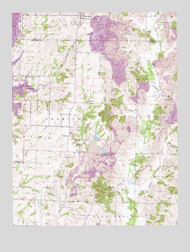
College Mound, MO USGS Topographic Map
Click on map above to begin viewing in our Map Viewer.

This topographic map contains these locations and features:
Feature Name Type Latitude Longitude GNIS ID View Map
Adams LakeReservoirN39.5650°W92.5485°761854View Map
Adams Lake DamDamN39.5650°W92.5485°761853View Map
Barnhart CemeteryCemeteryN39.5731°W92.5674°713689View Map
Brush CreekStreamN39.5803°W92.6058°714855View Map
Brush Creek School (historical)SchoolN39.5878°W92.6096°714873View Map
College MoundPopulated PlaceN39.6231°W92.5727°716118View Map
Crisman School (historical)SchoolN39.6006°W92.5471°743887View Map
DarksvillePopulated PlaceN39.5525°W92.5824°729299View Map
East Fork Walnut CreekStreamN39.5495°W92.5099°717306View Map
Edas ChapelChurchN39.5745°W92.5055°729305View Map
Eldad ChurchChurchN39.5378°W92.6191°729306View Map
Hickory Grove CemeteryCemeteryN39.5403°W92.5855°719458View Map
Hickory School (historical)SchoolN39.5717°W92.5527°743888View Map
Holiday Acres LakeReservoirN39.5624°W92.5044°719702View Map
Holiday Acres Lake Downstream DamDamN39.5600°W92.5052°760408View Map
Kohl LakeReservoirN39.5362°W92.5545°762115View Map
Kohl Lake DamDamN39.5350°W92.5502°762114View Map
Liberty School (historical)SchoolN39.5386°W92.5646°743889View Map
Nemo Coal Company HeliportAirportN39.5003°W92.5163°758614View Map
North ForkStreamN39.5492°W92.5099°723448View Map
Oakland School (historical)SchoolN39.5356°W92.5224°743890View Map
Riley Brancus Ranch HeliportAirportN39.5539°W92.5674°758730View Map
Riley LakeReservoirN39.5350°W92.5635°761223View Map
Riley Lake DamDamN39.5350°W92.5635°761222View Map
Solitude LakeReservoirN39.6042°W92.5461°761402View Map
Solitude Lake DamDamN39.6050°W92.5435°761401View Map
Stuck LakeReservoirN39.5438°W92.5754°761241View Map
Stuck Lake DamDamN39.5450°W92.5752°761240View Map
Thomas Brothers LakeReservoirN39.5432°W92.5560°761243View Map
Thomas Brothers Lake DamDamN39.5417°W92.5552°761242View Map
Township of CharitonCivilN39.5579°W92.6181°767257View Map
Union ChapelChurchN39.5803°W92.6144°729406View Map
Walnut CreekStreamN39.5200°W92.5394°728293View Map

Note: Coordinates in the location and feature list above are referenced to NAD83 datum.


Copyright (C) 2008-2024 Ryan Niemi / Sunset Dynamics ... All Rights Reserved