TopoQuest Logo
Do you find TopoQuest useful?
Help keep TopoQuest running and adding new maps/features by donating!
Bitcoin:  19c7KJd3qBynnjoSw5npx9KScwjBe4ifkT
Litecoin:  LXs6TkuXGGXo1vDsWCkWVdjQX94eUKd6ui
Home View Maps Find Maps Find Places Resources & Links


Colonias, New Mexico Topographic Map

USGS Map Title: Colonias, NM
USGS Map MRC: 35104A7
DRG (GeoTIFF) Download: o35104a7.tif


Neighboring USGS Topographic Map Quads:


  Pedro Miguel Peak, NM  
35104B8
 

  Horse Pasture Tank, NM  
35104B7
 

  Bar Y Ranch, NM  
35104B6
 

  Mesita De Guadalupe, NM  
35104A8
 

  Colonias, NM  
35104A7
 

  Catfish Falls, NM  
35104A6
 

  San Ignacio, NM  
34104H8
 

  Pastura NE, NM  
34104H7
 

  Santa Rosa, NM  
34104H6


Map MRC Location:

N36°
W105°
N36°
W104°
H8 H7 H6 H5 H4 H3 H2 H1
G8 G7 G6 G5 G4 G3 G2 G1
F8 F7 F6 F5 F4 F3 F2 F1
E8 E7 E6 E5 E4 E3 E2 E1
D8 D7 D6 D5 D4 D3 D2 D1
C8 C7 C6 C5 C4 C3 C2 C1
B8 B7 B6 B5 B4 B3 B2 B1
A8 A7 A6 A5 A4 A3 A2 A1
N35°
W105°
N35°
W104°

Colonias, NM USGS 1:24K Topographic Map Preview:
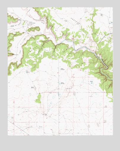
Colonias, NM USGS Topographic Map
Click on map above to begin viewing in our Map Viewer.

This topographic map contains these locations and features:
Feature Name Type Latitude Longitude GNIS ID View Map
Caņada de AbajoStreamN35.0989°W104.8325°897706View Map
Caņada de ArribaStreamN35.1178°W104.8517°897707View Map
Caņon de DesaqueValleyN35.0887°W104.8175°897766View Map
Caņon de UtaValleyN35.0881°W104.7975°897773View Map
Capps WellWellN35.1117°W104.8047°887179View Map
Casas del MedioCliffN35.1128°W104.8630°887254View Map
ColoniasPopulated PlaceN35.1098°W104.8472°918161View Map
Colonias Census Designated PlaceCensusN35.1144°W104.8571°2629106View Map
Colonias de San Jose Historic DistrictLocaleN35.1098°W104.8472°935653View Map
Colonias Post Office (historical)Post OfficeN35.1098°W104.8472°937974View Map
El Caņoncito de las CanovasValleyN35.0951°W104.8230°888797View Map
El CerritoSummitN35.0998°W104.8567°888799View Map
La Placita de Abajo Historic DistrictLocaleN35.1098°W104.8472°935745View Map
Laguna del ArabeLakeN35.0498°W104.8131°897957View Map
Laguna del DesaqueLakeN35.0648°W104.8132°897959View Map
Laguna del TulLakeN35.0458°W104.8425°897961View Map
Laguna SecaLakeN35.0519°W104.7757°897992View Map
Manuel Ulibarri RanchLocaleN35.0462°W104.8050°891586View Map
Margarito Ulibarri RanchLocaleN35.0198°W104.8297°891601View Map
Mesita CortadaSummitN35.1039°W104.8467°898823View Map
Mullins TankReservoirN35.0996°W104.7542°892338View Map
P Ulibarri RanchLocaleN35.0417°W104.8258°892992View Map
Punta de Mesa ColoradoSummitN35.0789°W104.8711°898841View Map
Repres de las UvasReservoirN35.0621°W104.8532°893867View Map
Rincon EntranosoAreaN35.0834°W104.8736°893935View Map
Rock TankLakeN35.1173°W104.7639°894077View Map
Sanchez WellWellN35.0176°W104.8686°894494View Map
Tank LakeLakeN35.1101°W104.7532°898448View Map
West WellWellN35.0378°W104.7772°896436View Map

Note: Coordinates in the location and feature list above are referenced to NAD83 datum.


Copyright (C) 2008-2025 Ryan Niemi / Sunset Dynamics ... All Rights Reserved