TopoQuest Logo
Do you find TopoQuest useful?
Help keep TopoQuest running and adding new maps/features by donating!
Bitcoin:  19c7KJd3qBynnjoSw5npx9KScwjBe4ifkT
Litecoin:  LXs6TkuXGGXo1vDsWCkWVdjQX94eUKd6ui
Home View Maps Find Maps Find Places Resources & Links


Colony, Kansas Topographic Map

USGS Map Title: Colony, KS
USGS Map MRC: 38095A3
DRG (GeoTIFF) Download: o38095a3.tif


Neighboring USGS Topographic Map Quads:


  Westphalia, KS  
38095B4
 

  Welda, KS  
38095B3
 

  Bush City, KS  
38095B2
 

  Geneva, KS  
38095A4
 

  Colony, KS  
38095A3
 

  Kincaid, KS  
38095A2
 

  Iola, KS  
37095H4
 

  La Harpe, KS  
37095H3
 

  Moran, KS  
37095H2


Map MRC Location:

N39°
W96°
N39°
W95°
H8 H7 H6 H5 H4 H3 H2 H1
G8 G7 G6 G5 G4 G3 G2 G1
F8 F7 F6 F5 F4 F3 F2 F1
E8 E7 E6 E5 E4 E3 E2 E1
D8 D7 D6 D5 D4 D3 D2 D1
C8 C7 C6 C5 C4 C3 C2 C1
B8 B7 B6 B5 B4 B3 B2 B1
A8 A7 A6 A5 A4 A3 A2 A1
N38°
W96°
N38°
W95°

Colony, KS USGS 1:24K Topographic Map Preview:
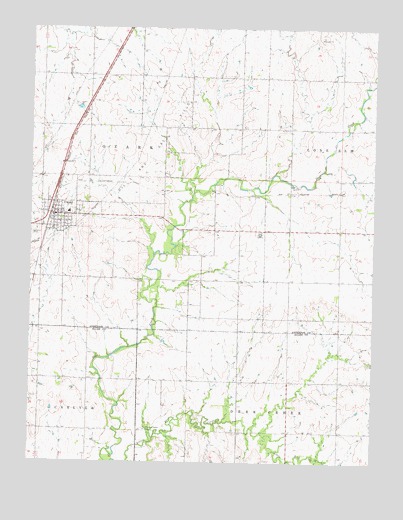
Colony, KS USGS Topographic Map
Click on map above to begin viewing in our Map Viewer.

This topographic map contains these locations and features:
Feature Name Type Latitude Longitude GNIS ID View Map
City of ColonyCivilN38.0711°W95.3626°2393603View Map
ColonyPopulated PlaceN38.0709°W95.3655°478124View Map
Colony CemeteryCemeteryN38.0653°W95.3625°2673183View Map
Colony Christian ChurchChurchN38.0710°W95.3654°2689780View Map
Colony City LibraryBuildingN38.0699°W95.3666°2694633View Map
Colony City Marshal's OfficeBuildingN38.0705°W95.3664°2504204View Map
Colony Fire StationBuildingN38.0704°W95.3664°2695501View Map
Colony United Methodist ChurchChurchN38.0705°W95.3654°2690221View Map
Colony Wastewater Treatment FacilityLocaleN38.0792°W95.3555°2692015View Map
Crest Elementary SchoolSchoolN38.0718°W95.3619°480822View Map
Crest High SchoolSchoolN38.0720°W95.3614°480821View Map
Diamond Church (historical)ChurchN38.0231°W95.2800°482772View Map
Diamond School (historical)SchoolN38.0086°W95.2811°482773View Map
Pleasant Valley CemeteryCemeteryN38.0095°W95.3328°478123View Map
Prairie Union School (historical)SchoolN38.0242°W95.3705°482804View Map
Township of OzarkCivilN38.0821°W95.3535°478121View Map
Wise School (historical)SchoolN38.0239°W95.3272°482821View Map

Note: Coordinates in the location and feature list above are referenced to NAD83 datum.


Copyright (C) 2008-2024 Ryan Niemi / Sunset Dynamics ... All Rights Reserved