TopoQuest Logo
Do you find TopoQuest useful?
Help keep TopoQuest running and adding new maps/features by donating!
Bitcoin:  19c7KJd3qBynnjoSw5npx9KScwjBe4ifkT
Litecoin:  LXs6TkuXGGXo1vDsWCkWVdjQX94eUKd6ui
Home View Maps Find Maps Find Places Resources & Links


La Harpe, Kansas Topographic Map

USGS Map Title: La Harpe, KS
USGS Map MRC: 37095H3
DRG (GeoTIFF) Download: o37095h3.tif


Neighboring USGS Topographic Map Quads:


  Geneva, KS  
38095A4
 

  Colony, KS  
38095A3
 

  Kincaid, KS  
38095A2
 

  Iola, KS  
37095H4
 

  La Harpe, KS  
37095H3
 

  Moran, KS  
37095H2
 

  Humboldt, KS  
37095G4
 

  Iola SE, KS  
37095G3
 

  Elsmore, KS  
37095G2


Map MRC Location:

N38°
W96°
N38°
W95°
H8 H7 H6 H5 H4 H3 H2 H1
G8 G7 G6 G5 G4 G3 G2 G1
F8 F7 F6 F5 F4 F3 F2 F1
E8 E7 E6 E5 E4 E3 E2 E1
D8 D7 D6 D5 D4 D3 D2 D1
C8 C7 C6 C5 C4 C3 C2 C1
B8 B7 B6 B5 B4 B3 B2 B1
A8 A7 A6 A5 A4 A3 A2 A1
N37°
W96°
N37°
W95°

La Harpe, KS USGS 1:24K Topographic Map Preview:
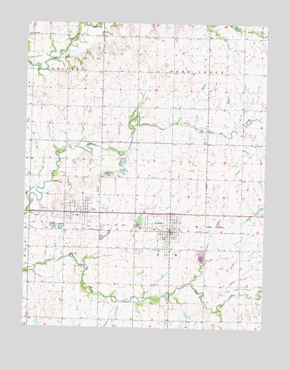
La Harpe, KS USGS Topographic Map
Click on map above to begin viewing in our Map Viewer.

This topographic map contains these locations and features:
Feature Name Type Latitude Longitude GNIS ID View Map
Allen Center School (historical)SchoolN37.8784°W95.3164°482761View Map
Allen CountyCivilN37.8857°W95.3014°484970View Map
Allen County Country ClubLocaleN37.9255°W95.3564°2694544View Map
Allen County LandfillLocaleN37.9044°W95.2860°2692265View Map
City of GasCivilN37.9228°W95.3452°2394865View Map
City of La HarpeCivilN37.9169°W95.3025°485604View Map
Community of ChristChurchN37.9216°W95.3651°2689762View Map
Deer Creek School (historical)SchoolN37.9945°W95.3683°482770View Map
Elm Creek School (historical)SchoolN37.9078°W95.3683°482777View Map
GasPopulated PlaceN37.9236°W95.3461°474510View Map
Gas City CemeteryCemeteryN37.9321°W95.3369°474512View Map
Gas City HallBuildingN37.9240°W95.3448°2693342View Map
Gas Post OfficePost OfficeN37.9223°W95.3425°2693733View Map
Independence School (historical)SchoolN37.8784°W95.2811°482784View Map
Kingdom Hall of Jehovah's WitnessesChurchN37.9234°W95.3531°2689097View Map
La HarpePopulated PlaceN37.9170°W95.2991°474511View Map
La Harpe CemeteryCemeteryN37.9069°W95.3026°474509View Map
La Harpe Christian ChurchChurchN37.9134°W95.2988°2690851View Map
La Harpe City HallBuildingN37.9153°W95.2993°2693219View Map
La Harpe Fire DepartmentBuildingN37.9156°W95.2995°2111501View Map
La Harpe Police DepartmentBuildingN37.9152°W95.2993°2503907View Map
La Harpe Post OfficePost OfficeN37.9144°W95.2994°2693809View Map
La Harpe Rural Fire DepartmentBuildingN37.9101°W95.3011°2111502View Map
La Harpe Senior Citizens CenterBuildingN37.9211°W95.2987°2692907View Map
La Harpe Wastewater PlantLocaleN37.9128°W95.3109°2693407View Map
LaHarpe Elementary SchoolSchoolN37.9133°W95.3008°480857View Map
Little Deer CreekStreamN37.9995°W95.3469°478128View Map
Midway Air Park (historical)AirportN37.9209°W95.2753°481363View Map
National Airport (historical)AirportN37.9120°W95.3503°481403View Map
North Fairview School (historical)SchoolN37.9511°W95.2803°482790View Map
Pioneer CemeteryCemeteryN37.9800°W95.3537°2110842View Map
Rock Creek School (historical)SchoolN37.9556°W95.3728°482807View Map
Saint John's Catholic CemeteryCemeteryN37.9306°W95.3368°2673184View Map
Silver Leaf School (historical)SchoolN37.9514°W95.3353°482811View Map
Spring Branch School (historical)SchoolN37.9798°W95.3178°482813View Map
Township of Deer CreekCivilN37.9945°W95.2804°478126View Map
Township of ElmCivilN37.9072°W95.2989°474514View Map
Trailside Mobile Home ParkPopulated PlaceN37.9183°W95.3452°2694175View Map
Trailside Mobile Home VillagePopulated PlaceN37.9186°W95.3456°2694176View Map
Waverly School (historical)SchoolN37.9798°W95.2619°482819View Map
WiseLocaleN37.9945°W95.2803°482094View Map

Note: Coordinates in the location and feature list above are referenced to NAD83 datum.


Copyright (C) 2008-2025 Ryan Niemi / Sunset Dynamics ... All Rights Reserved