TopoQuest Logo
Do you find TopoQuest useful?
Help keep TopoQuest running and adding new maps/features by donating!
Bitcoin:  19c7KJd3qBynnjoSw5npx9KScwjBe4ifkT
Litecoin:  LXs6TkuXGGXo1vDsWCkWVdjQX94eUKd6ui
Home View Maps Find Maps Find Places Resources & Links


Commerce, Georgia Topographic Map

USGS Map Title: Commerce, GA
USGS Map MRC: 34083B4
DRG (GeoTIFF) Download: o34083b4.tif


Neighboring USGS Topographic Map Quads:


  Maysville, GA  
34083C5
 

  Homer, GA  
34083C4
 

  Ashland, GA  
34083C3
 

  Apple Valley, GA  
34083B5
 

  Commerce, GA  
34083B4
 

  Ila, GA  
34083B3
 

  Jefferson, GA  
34083A5
 

  Nicholson, GA  
34083A4
 

  Hull, GA  
34083A3


Map MRC Location:

N35°
W84°
N35°
W83°
H8 H7 H6 H5 H4 H3 H2 H1
G8 G7 G6 G5 G4 G3 G2 G1
F8 F7 F6 F5 F4 F3 F2 F1
E8 E7 E6 E5 E4 E3 E2 E1
D8 D7 D6 D5 D4 D3 D2 D1
C8 C7 C6 C5 C4 C3 C2 C1
B8 B7 B6 B5 B4 B3 B2 B1
A8 A7 A6 A5 A4 A3 A2 A1
N34°
W84°
N34°
W83°

Commerce, GA USGS 1:24K Topographic Map Preview:
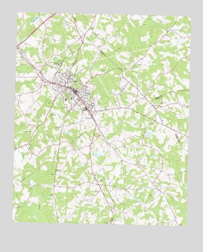
Commerce, GA USGS Topographic Map
Click on map above to begin viewing in our Map Viewer.

This topographic map contains these locations and features:
Feature Name Type Latitude Longitude GNIS ID View Map
Banks County Fire Station 340BuildingN34.2398°W83.3860°2604118View Map
Benton CemeteryCemeteryN34.1415°W83.4702°311102View Map
Berea CemeteryCemeteryN34.1429°W83.3999°349556View Map
Berea ChurchChurchN34.1429°W83.4004°354552View Map
Black Creek ChurchChurchN34.1976°W83.3957°354749View Map
Blacksprings ChurchChurchN34.2151°W83.3965°349238View Map
Borders CreekStreamN34.1534°W83.4841°311660View Map
Cabin Creek CemeteryCemeteryN34.1393°W83.4477°349426View Map
Cabin Creek ChurchChurchN34.1390°W83.4477°354932View Map
Calvary ChurchChurchN34.2248°W83.4616°349427View Map
Chandler CemeteryCemeteryN34.1965°W83.4007°312554View Map
Chandler School (historical)SchoolN34.2265°W83.4029°349245View Map
City of CommerceCivilN34.2131°W83.4731°2404114View Map
CommercePopulated PlaceN34.2040°W83.4571°355254View Map
Commerce City HallBuildingN34.2026°W83.4568°349561View Map
Commerce City ParkParkN34.2015°W83.4618°349434View Map
Commerce Commercial Historic DistrictParkN34.2037°W83.4563°349435View Map
Commerce Country ClubLocaleN34.1904°W83.4718°344214View Map
Commerce DivisionCivilN34.1938°W83.4539°1936196View Map
Commerce Elementary SchoolSchoolN34.1934°W83.4620°349436View Map
Commerce High SchoolSchoolN34.1988°W83.4633°349437View Map
Commerce Junior High SchoolSchoolN34.2026°W83.4490°349438View Map
Commerce Middle SchoolSchoolN34.1879°W83.4754°349439View Map
Commerce Police DepartmentBuildingN34.2006°W83.4552°2734037View Map
Commerce Primary SchoolSchoolN34.1954°W83.4620°2545681View Map
Commerce Public LibraryBuildingN34.1998°W83.4527°349440View Map
Commerce Volunteer Fire DepartmentBuildingN34.2005°W83.4552°2603765View Map
Commerce WaterworksLocaleN34.1821°W83.4663°344215View Map
Doug Bolton FieldAirportN34.2026°W83.4291°351718View Map
Dunson CemeteryCemeteryN34.1645°W83.4102°313732View Map
East Jackson Comprehensive High SchoolSchoolN34.1430°W83.4632°2545699View Map
East Jackson Elementary SchoolSchoolN34.1458°W83.4679°2545725View Map
East Jackson Middle SchoolSchoolN34.1492°W83.4721°2545703View Map
Five PointsPopulated PlaceN34.2412°W83.3904°326289View Map
Full Gospel TabernacleChurchN34.1437°W83.4388°314449View Map
Gray Hill CemeteryCemeteryN34.1970°W83.4540°314799View Map
Hardaman Heights School (historical)SchoolN34.1868°W83.4243°349461View Map
Harmony CemeteryCemeteryN34.2232°W83.4957°349462View Map
Harmony Christian ChurchChurchN34.2229°W83.4954°349463View Map
Harris-Lord CemeteryCemeteryN34.1459°W83.4218°315200View Map
Hills LakeReservoirN34.2460°W83.4865°315436View Map
Hills Lake DamDamN34.2482°W83.4857°337363View Map
Hoods Academy (historical)SchoolN34.1418°W83.4474°349469View Map
Hoods LakeReservoirN34.1638°W83.4396°339179View Map
Hoods Lake DamDamN34.1651°W83.4399°339178View Map
Hoods Mill (historical)LocaleN34.1459°W83.4871°349470View Map
Howington CemeteryCemeteryN34.1254°W83.4302°315771View Map
Iveys LakeReservoirN34.1874°W83.4266°337352View Map
Iveys Lake DamDamN34.1884°W83.4249°337351View Map
Jackson Memorial ParkCemeteryN34.1790°W83.4868°316017View Map
Jones ChapelChurchN34.1282°W83.4679°349490View Map
Lords Corner School (historical)SchoolN34.2018°W83.4115°349572View Map
Marlow LakeReservoirN34.1790°W83.4631°339181View Map
Marlow Lake DamDamN34.1801°W83.4649°339180View Map
Mount Bethel CemeteryCemeteryN34.2379°W83.4432°349278View Map
Mount Bethel ChurchChurchN34.2376°W83.4438°318563View Map
Mount Bethel School (historical)SchoolN34.2373°W83.4438°349279View Map
Mount Olive CemeteryCemeteryN34.2201°W83.4827°349501View Map
Mount Olive ChurchChurchN34.2204°W83.4829°318774View Map
Northridge Medical CenterHospitalN34.2198°W83.4690°310778View Map
Parks CreekStreamN34.1343°W83.4888°320239View Map
Reservoir 12ReservoirN34.1485°W83.3756°337346View Map
Reservoir 15ReservoirN34.1793°W83.4031°337340View Map
Reservoir 18ReservoirN34.1658°W83.3993°337344View Map
Reservoir 23ReservoirN34.1404°W83.4123°337372View Map
Riley BranchStreamN34.1451°W83.3777°349523View Map
Rogers CemeteryCemeteryN34.1540°W83.4704°321875View Map
Sanders LakeReservoirN34.2126°W83.4097°339219View Map
Sanders Lake DamDamN34.2134°W83.4082°339218View Map
Sandy Creek Structure 12 DamDamN34.1468°W83.3765°337345View Map
Sandy Creek Structure 15 DamDamN34.1768°W83.4015°337339View Map
Sandy Creek Structure 18 DamDamN34.1668°W83.3982°337343View Map
Sandy Creek Structure 23 DamDamN34.1401°W83.4099°337371View Map
Thyatira ChurchChurchN34.2082°W83.4210°349535View Map
Turkey CreekStreamN34.1782°W83.4829°349537View Map
Wilson CemeteryCemeteryN34.1315°W83.4479°325426View Map
Wilson CemeteryCemeteryN34.1820°W83.3821°335566View Map
WJJC-AM (Commerce)TowerN34.2159°W83.4357°352402View Map

Note: Coordinates in the location and feature list above are referenced to NAD83 datum.


Copyright (C) 2008-2024 Ryan Niemi / Sunset Dynamics ... All Rights Reserved