TopoQuest Logo
Do you find TopoQuest useful?
Help keep TopoQuest running and adding new maps/features by donating!
Bitcoin:  19c7KJd3qBynnjoSw5npx9KScwjBe4ifkT
Litecoin:  LXs6TkuXGGXo1vDsWCkWVdjQX94eUKd6ui
Home View Maps Find Maps Find Places Resources & Links


Apple Valley, Georgia Topographic Map

USGS Map Title: Apple Valley, GA
USGS Map MRC: 34083B5
DRG (GeoTIFF) Download: o34083b5.tif


Neighboring USGS Topographic Map Quads:


  Gillsville, GA  
34083C6
 

  Maysville, GA  
34083C5
 

  Homer, GA  
34083C4
 

  Pendergrass, GA  
34083B6
 

  Apple Valley, GA  
34083B5
 

  Commerce, GA  
34083B4
 

  Winder North, GA  
34083A6
 

  Jefferson, GA  
34083A5
 

  Nicholson, GA  
34083A4


Map MRC Location:

N35°
W84°
N35°
W83°
H8 H7 H6 H5 H4 H3 H2 H1
G8 G7 G6 G5 G4 G3 G2 G1
F8 F7 F6 F5 F4 F3 F2 F1
E8 E7 E6 E5 E4 E3 E2 E1
D8 D7 D6 D5 D4 D3 D2 D1
C8 C7 C6 C5 C4 C3 C2 C1
B8 B7 B6 B5 B4 B3 B2 B1
A8 A7 A6 A5 A4 A3 A2 A1
N34°
W84°
N34°
W83°

Apple Valley, GA USGS 1:24K Topographic Map Preview:
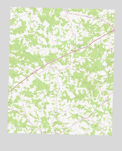
Apple Valley, GA USGS Topographic Map
Click on map above to begin viewing in our Map Viewer.

This topographic map contains these locations and features:
Feature Name Type Latitude Longitude GNIS ID View Map
Academy School (historical)SchoolN34.1443°W83.6191°349416View Map
Apple ValleyPopulated PlaceN34.1587°W83.5093°326157View Map
Apple Valley Baptist ChurchChurchN34.1568°W83.5107°349417View Map
Apple Valley CemeteryCemeteryN34.1570°W83.5121°349418View Map
Bennett CemeteryCemeteryN34.1445°W83.5202°311084View Map
Candler BridgeBridgeN34.2304°W83.5691°349428View Map
Candler CreekStreamN34.2368°W83.5835°312279View Map
Carr LakeReservoirN34.2212°W83.5561°339183View Map
Carr Lake DamDamN34.2201°W83.5549°339182View Map
Cave Springs CemeteryCemeteryN34.1957°W83.6116°349429View Map
Cave Springs ChurchChurchN34.1959°W83.6116°355042View Map
City of JeffersonCivilN34.1366°W83.6022°2404795View Map
Dry PondPopulated PlaceN34.1915°W83.5749°313686View Map
Dry Pond CemeteryCemeteryN34.1915°W83.5735°349445View Map
Dry Pond CemeteryCemeteryN34.1918°W83.5774°349446View Map
Dry Pond Methodist ChurchChurchN34.1918°W83.5771°349447View Map
Exit 51CrossingN34.1862°W83.5941°1705025View Map
Exit 52CrossingN34.2298°W83.5002°1705026View Map
Faith CemeteryCemeteryN34.1368°W83.5996°349453View Map
Faith ChurchChurchN34.1371°W83.5996°355769View Map
Gravelly CreekStreamN34.2026°W83.5157°314791View Map
Harrisburg Fire DepartmentBuildingN34.1432°W83.5296°2603827View Map
Holder PlantationLocaleN34.1509°W83.6207°349465View Map
Hurricane Grove ChurchChurchN34.2084°W83.5518°315855View Map
Hurricane ShoalBarN34.2123°W83.5424°315858View Map
Hurricane Shoals (historical)Populated PlaceN34.2118°W83.5443°349473View Map
Hurricane Shoals County ParkParkN34.2126°W83.5413°349474View Map
Jackson CountyCivilN34.1339°W83.5663°349570View Map
Jackson County AirportAirportN34.1720°W83.5588°351806View Map
Jackson County Correctional InstitutionBuildingN34.1445°W83.5558°2735702View Map
Jackson County Farm (historical)LocaleN34.1482°W83.5554°349479View Map
Jackson County JailBuildingN34.1421°W83.5593°2734219View Map
Jackson County Senior Citizen CenterBuildingN34.1412°W83.5596°349481View Map
Jackson County Sheriff's OfficeBuildingN34.1414°W83.5591°2733602View Map
Jefferson City LakeReservoirN34.1302°W83.5711°337366View Map
Jefferson City Lake DamDamN34.1284°W83.5699°337365View Map
Little Gravelly CreekStreamN34.1951°W83.5138°349495View Map
Maysville DivisionCivilN34.2222°W83.6000°1936399View Map
Maysville Elementary SchoolSchoolN34.2446°W83.5563°349499View Map
Middle Oconee Walnut Creek 16 DamDamN34.1834°W83.6182°338764View Map
Middle Oconee-Walnut Creek Number 17 DamDamN34.1701°W83.6232°337357View Map
Mill BranchStreamN34.2165°W83.5593°349500View Map
Oconee CemeteryCemeteryN34.1862°W83.5641°349509View Map
Oconee ChurchChurchN34.1859°W83.5629°319896View Map
Reservoir 16ReservoirN34.1834°W83.6182°338765View Map
Reservoir 17ReservoirN34.1711°W83.6220°337358View Map
Riverside CemeteryCemeteryN34.2229°W83.5482°349524View Map
Riverside ChurchChurchN34.2243°W83.5493°321651View Map
Sardus ChurchChurchN34.1396°W83.5277°322564View Map
Stockton CreekStreamN34.2173°W83.5588°349528View Map
ThyatiraPopulated PlaceN34.1412°W83.5332°333227View Map
Thyatira CemeteryCemeteryN34.1390°W83.5379°349533View Map
Thyatira ChurchChurchN34.1437°W83.5304°349534View Map
Thyatira Presbyterian ChurchChurchN34.1390°W83.5368°349536View Map
Toney Hill ChurchChurchN34.1471°W83.5674°324224View Map
Unity Christian Church CemeteryCemeteryN34.2499°W83.6063°349539View Map
Wheeler CemeteryCemeteryN34.2276°W83.5307°325121View Map
Wheeler School (historical)SchoolN34.2246°W83.5493°349544View Map
Wilson Chapel Methodist CemeteryCemeteryN34.2409°W83.5224°349546View Map
Wilson ChurchChurchN34.2409°W83.5216°325431View Map
Woods BridgeBridgeN34.2007°W83.5157°349548View Map

Note: Coordinates in the location and feature list above are referenced to NAD83 datum.


Copyright (C) 2008-2024 Ryan Niemi / Sunset Dynamics ... All Rights Reserved