TopoQuest Logo
Do you find TopoQuest useful?
Help keep TopoQuest running and adding new maps/features by donating!
Bitcoin:  19c7KJd3qBynnjoSw5npx9KScwjBe4ifkT
Litecoin:  LXs6TkuXGGXo1vDsWCkWVdjQX94eUKd6ui
Home View Maps Find Maps Find Places Resources & Links


Conchas Dam, New Mexico Topographic Map

USGS Map Title: Conchas Dam, NM
USGS Map MRC: 35104D2
DRG (GeoTIFF) Download: o35104d2.tif


Neighboring USGS Topographic Map Quads:


  Wade Canyon, NM  
35104E3
 

  Minese Mesa, NM  
35104E2
 

  Bell Ranch, NM  
35104E1
 

  Four V Ranch, NM  
35104D3
 

  Conchas Dam, NM  
35104D2
 

  La Cinta Mesa, NM  
35104D1
 

  Bookout Ranch, NM  
35104C3
 

  Tenaja Mesa, NM  
35104C2
 

  Monument Point, NM  
35104C1


Map MRC Location:

N36°
W105°
N36°
W104°
H8 H7 H6 H5 H4 H3 H2 H1
G8 G7 G6 G5 G4 G3 G2 G1
F8 F7 F6 F5 F4 F3 F2 F1
E8 E7 E6 E5 E4 E3 E2 E1
D8 D7 D6 D5 D4 D3 D2 D1
C8 C7 C6 C5 C4 C3 C2 C1
B8 B7 B6 B5 B4 B3 B2 B1
A8 A7 A6 A5 A4 A3 A2 A1
N35°
W105°
N35°
W104°

Conchas Dam, NM USGS 1:24K Topographic Map Preview:
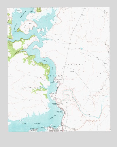
Conchas Dam, NM USGS Topographic Map
Click on map above to begin viewing in our Map Viewer.

This topographic map contains these locations and features:
Feature Name Type Latitude Longitude GNIS ID View Map
Aguilar MesaSummitN35.4853°W104.2250°898715View Map
Alamosa Plaza CemeteryCemeteryN35.4953°W104.2327°885647View Map
Bell Ranch CanalCanalN35.4053°W104.1769°886186View Map
Bell Ranch Headquarters Historic SiteBuildingN35.4028°W104.1900°933509View Map
Big IslandIslandN35.4778°W104.2100°886309View Map
Boot CanyonValleyN35.4181°W104.2019°886613View Map
Campers IslandIslandN35.4803°W104.2103°887117View Map
Cannon Air Force Base Recreation AreaParkN35.3789°W104.2033°887138View Map
Catfish CoveBayN35.4964°W104.2197°887286View Map
Cedar PointCapeN35.4770°W104.2378°887348View Map
Clabber Hill RanchLocaleN35.4173°W104.1339°887633View Map
Conchas Aquatic CampLocaleN35.4128°W104.1953°887767View Map
Conchas Baptist MissionChurchN35.4028°W104.1900°920973View Map
Conchas DamDamN35.4029°W104.1905°887770View Map
Conchas Dam Fire / Rescue Station 2BuildingN35.4231°W104.1841°2658242View Map
Conchas Dam Post OfficePost OfficeN35.4170°W104.1355°938532View Map
Conchas Dam Post Office (historical)Post OfficeN35.4028°W104.1900°937636View Map
Conchas Dam Weather StationLocaleN35.4003°W104.1900°932586View Map
Conchas LakeReservoirN35.3849°W104.2180°897344View Map
Conchas Lake Seaplane BaseAirportN35.3842°W104.2164°936932View Map
Conchas Lake State ParkParkN35.3942°W104.1819°887771View Map
Conchas SchoolSchoolN35.3764°W104.1800°887776View Map
Costilla CanyonValleyN35.4828°W104.2455°887887View Map
Four V CanyonValleyN35.4678°W104.2419°889186View Map
Graveyard PocketBasinN35.4962°W104.2397°889570View Map
HoovervillePopulated PlaceN35.3762°W104.2178°899675View Map
Indian Writings Historic SiteLocaleN35.4028°W104.1900°933395View Map
Jose Maria CanyonValleyN35.4573°W104.2269°890573View Map
La Cinta (historical)Populated PlaceN35.4109°W104.1316°915786View Map
La Cinta CemeteryCemeteryN35.4109°W104.1317°890785View Map
La Cinta Post Office (historical)Post OfficeN35.4109°W104.1316°937226View Map
Murrells RanchLocaleN35.4170°W104.1355°924507View Map
North DockLocaleN35.4248°W104.1936°892579View Map
Rattlesnake IslandIslandN35.3839°W104.2314°893688View Map
San Miguel County Fire District Conchas Dam Fire and Rescue Station 3BuildingN35.3776°W104.1811°2658049View Map
South DockLocaleN35.3800°W104.1941°895035View Map
Spring CanyonValleyN35.4684°W104.2066°895250View Map
Tulosa DrawValleyN35.4431°W104.1330°895896View Map
Tulosa TankReservoirN35.4583°W104.1593°895897View Map
Tulosa WindmillLocaleN35.4434°W104.1316°895898View Map

Note: Coordinates in the location and feature list above are referenced to NAD83 datum.


Copyright (C) 2008-2025 Ryan Niemi / Sunset Dynamics ... All Rights Reserved